Maps of Alsfeld
Ungefährlicher Entwurf den Ämbter Alssfeldt, Rümrodt, Grebenau, der Gerichte Schwarz und von Süsser Gerichte
1 : 35000 [S.l. : s.n.]
Section Alsfeld
Eckhardt, Christian Leonhard Philipp; Haas, Johann Heinrich; Meister, G.; Klos
Abbatia Heresfeldensis. vulgo 't Stifftt Hirsfeldt. [Karte], in: Gerardi Mercatoris et I. Hondii Newer Atlas, oder, Grosses Weltbuch, Bd. 1, S. 295.
1 Karte aus Atlas Mercator, Gerhard und Hondius, Jodocus Jansson, Jan
Territorium Abbatiae Heresfeldensis. 't Stift Hirszfeldt. [Karte], in: Novus Atlas, das ist, Weltbeschreibung, Bd. 1, S. 153.
1 Karte aus Atlas Blaeu, Joan Blaeu, Willem Janszoon
Territorium Abbatiae Heresfeldensis. 't Stift Hirßfeldt. [Karte], in: Le théâtre du monde, ou, Nouvel atlas contenant les chartes et descriptions de tous les païs de la terre, Bd. 1, S. 184.
1 Karte aus Atlas Blaeu, Willem Janszoon und Blaeu, Joan Blaeu, Willem Janszoon
Territorium Abbatiae Heresfeldensis. 't Stift Hirßfeldt. [Karte], in: Novus atlas absolutissimus, Bd. 2, S. 171.
1 Karte aus Atlas Janssonius Offizin
Territorium Abbatiae Heresfeldensis. 't Stift Hirßfeldt. [Karte], in: Theatrum orbis terrarum, sive, Atlas novus, Bd. 1, S. 242.
1 Karte aus Atlas Blaeu, Joan Blaeu, Willem Janszoon
Territorivm abbatiae Heresfeldensis = 't Stift Hirszfeldt
1 : 70000 titelvariant: 't Stift Hirszfeldt; Annotatie: Origineel is Blad 103 in atlas factice; Annotatie geografische gegevens: Schaalvermeldingen linksonder: Dimidium milliaris Haßici, en: Dimidium milliaris Germanici Willem Jansz Blaeu 1571-1638 [Amsterdami : apud Guiljelmum Blaeu]
TERRITORIVM | ABBATIÆ HERESFEL- | DENSIS. | 't Stift | Hirszfeldt.
Apud Guiljelmum Blaeu.
Abbatia Heresfeldensis vulgo t'Stifft Hirsfeldt
1 : 60000 Mollova mapová sbírka Schenk, Pieter Schenk, Peter I
Abbatia Heresfeldensis vulgo t'Stifft Hirsfeldt
1 : 60000 Mollova mapová sbírka Blaeu, Willem Janszoon Blaeu, Willem Jansz.
Abbatia Heresfeldensis vulgo t'Stifft Hirsfeldt
1 : 60000 Mollova mapová sbírka Hondius, Henricus Hondius, Henricus
Meßtischblatt 3112 : Salzschlirf, 1908
1 : 250000 Salzschlirf. - Aufn. 1906. - 1:25000. - [Berlin]: Kgl. Preuss. Landesaufnahme, 1908. - 1 Kt.
Meßtischblatt 5223 : Queck (Breitenbach a. Herzberge), 1926
1 : 250000 Queck (Breitenbach a. Herzberge). - Bearb. 1906 - 1907, Nachtr. 1926. - 1:25000. - [Berlin]: Reichsamt für Landesaufnahme, 1926. - 1 Kt.
Meßtischblatt 3049 : Lingelbach, 1908
1 : 250000 Lingelbach. - Aufn. 1906. - 1:25000. - [Berlin]: Kgl. Preuss. Landesaufnahme, 1908. - 1 Kt.
Meßtischblatt 2987 . Niederaula, 1936
1 : 250000 Niederaula. - Hrsg. 1908, einzelne Nachtr. 1936. - 1:25000. - [Berlin]: Reichsamt für Landesaufnahme, 1936. - 1 Kt.
Meßtischblatt 5122 : Neukirchen i. Hessen-Nassau,1941
1 : 250000 Neukirchen i. Hessen-Nassau. - Hrsg. 1908, letzte Nachtr. 1939, Ausg. 1941. - 1:25000. - [Berlin]: Reichsamt für Landesaufnahme, 1941. - 1 Kt.
Meßtischblatt 3113 : Hünfeld, 1908
1 : 250000 Hünfeld. - Aufn. 1905. - 1:25000. - [Berlin]: Kgl. Preuss. Landesaufnahme, 1907. - 1 Kt.
Meßtischblatt 3051 : Eiterfeld, 1936
1 : 250000 Eiterfeld. - Hrsg. 1907, bericht. 1910, einzelne Nachtr. 1936. - 1:25000. - [Berlin]: Reichsamt für Landesaufnahme, 1936. - 1 Kt.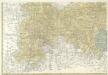
Landgrafiatvs Hasso-Cassellanvs typo geographico quatuor Foliorum expressus Cura Homannianorum Heredum Norimb: 1761
1 : 160000 Mollova mapová sbírka Homann, Johann Baptist Homann, Johann Baptista - dědici
Landgraviatus Hassiae Inferioris Comitatvs Waldeciae Eichsfeldiae Tabvla Geographica
1 : 140000 Mollova mapová sbírka Berger, Daniel
Delineatio Geographica generalis comprehendens VI. Foliis Singulos Principatvs Comitatvs Ditiones Dynastias omnes quotquot Imperio Serenissimi Principis Landgrafii Hasso-Darmstadiensis subsunt :
1 : 180000 Mollova mapová sbírka Bronner, Christian Maximilian Homann, Johann Baptista - dědici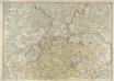
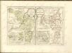
S. R. I. Principatvs Fvldensis in Bvchonia
1 : 210000 Mollova mapová sbírka Homann, Johann Baptist Homann, Johann Baptista
126. Fulda, uit: Topographische Uebersichtskarte des Deutschen Reiches / herausgegeben v. d. Kartogr. Abt. d. Königl. Preuß. Landesaufnahme
1 : 200000 titelvariant: Topogr. Übersichtskarte des Deutschen Reiches; Annotatie: Titel boven bladen ook: Topogr. Übersichtskarte des Deutschen Reiches; Annotatie geografische gegevens: Op elk blad twee maatstokken: 10 Kilometer = 5,5 cm; 1 geogr. Meile = 3,6 cm; Legenda onder op elk blad Königlich Preußische Landesaufnahme. Kartographische Abtheilung [S.l : Königlich Preußische Landesaufnahme, Kartographische Abtheilung]
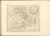
Section Giessen, uit: Charte von dem Grossherzogtum Hessen und dem Herzogtum Nassau / trigonometrisch aufgenommen und hrsg. von C.L.P. Eckhardt
1 : 200000 titelvariant: Karte von Hessen und Nassau Eckhardt, C. L. P Darmstadt : Joh. Wilh. Heyer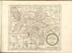

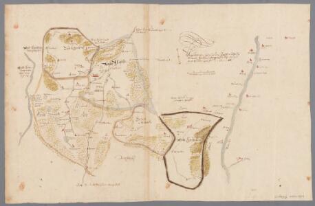
Bewegungen der Alliirten, und Französischen Armee zwischen dem 19ten und 21ten März 1761, nebst Aufstellung und Rückzug der Alliirten am 23ten und 24ten

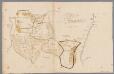
Bvchaviae, siue Fvldensis ditionis typvs
1 Karte : Kupferdruck ; 30 x 21 cm Regerwyl; Ortelius s.n.