Maps of Landkreis Fulda

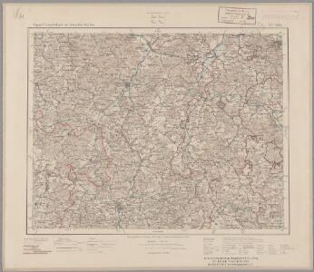
126. Fulda, uit: Topographische Uebersichtskarte des Deutschen Reiches / herausgegeben v. d. Kartogr. Abt. d. Königl. Preuß. Landesaufnahme
1 : 200000 titelvariant: Topogr. Übersichtskarte des Deutschen Reiches; Annotatie: Titel boven bladen ook: Topogr. Übersichtskarte des Deutschen Reiches; Annotatie geografische gegevens: Op elk blad twee maatstokken: 10 Kilometer = 5,5 cm; 1 geogr. Meile = 3,6 cm; Legenda onder op elk blad Königlich Preußische Landesaufnahme. Kartographische Abtheilung [S.l : Königlich Preußische Landesaufnahme, Kartographische Abtheilung]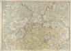
S. R. I. Principatvs Fvldensis in Bvchonia
1 : 210000 Mollova mapová sbírka Homann, Johann Baptist Homann, Johann Baptista
163 Fulda, uit: Topographische Special-Karte von Deutschland (von Central-Europa) / begründet von D.G. Reymann ; [entworfen und gezeichn. von Heinrich Berghaus... [et al.]]
1 : 200000 Annotatie: Lit.: Daniel Gottlob Reymann und die "Topographische Special-Karte von Deutschland" / von Wolfgang Scharfe, in: Kartographische Nachrichten, 39 (1989), Heft I, p. 1-10; Handgeschreven titel: Reymann's Deutschland : 24 Sectionen: Jena, Penig, Dresden, Zittau, Hirschberg, Breslau, Brieg, Andernach, Coblenz, Giessen, Fulda, Schleusingen, Plauen, Zwickau, Teplitz, Jung Bunzlau, Hohenelbe, Glatz, Neisse, Simmern, Prag, Luxemburg, Birkenfeld; Aanwezig: 23 bladen Reymann, Daniel Gottlob; Berghaus, Heinrich [Berlin : 2. Departement des Kriegsministeriums, Bureau für Plan- und Kartenzeichnung]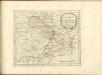
Ungefährlicher Entwurf den Ämbter Alssfeldt, Rümrodt, Grebenau, der Gerichte Schwarz und von Süsser Gerichte
1 : 35000 [S.l. : s.n.]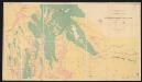
Territorium Abbatiae Heresfeldensis. 't Stift Hirßfeldt. [Karte], in: Le théâtre du monde, ou, Nouvel atlas contenant les chartes et descriptions de tous les païs de la terre, Bd. 1, S. 184.
1 Karte aus Atlas Blaeu, Willem Janszoon und Blaeu, Joan Blaeu, Willem Janszoon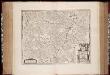
Territorivm abbatiae Heresfeldensis = 't Stift Hirszfeldt
1 : 70000 titelvariant: 't Stift Hirszfeldt; Annotatie: Origineel is Blad 103 in atlas factice; Annotatie geografische gegevens: Schaalvermeldingen linksonder: Dimidium milliaris Haßici, en: Dimidium milliaris Germanici Willem Jansz Blaeu 1571-1638 [Amsterdami : apud Guiljelmum Blaeu]
Abbatia Heresfeldensis. vulgo 't Stifftt Hirsfeldt. [Karte], in: Gerardi Mercatoris et I. Hondii Newer Atlas, oder, Grosses Weltbuch, Bd. 1, S. 295.
1 Karte aus Atlas Mercator, Gerhard und Hondius, Jodocus Jansson, Jan
Territorium Abbatiae Heresfeldensis. 't Stift Hirßfeldt. [Karte], in: Novus atlas absolutissimus, Bd. 2, S. 171.
1 Karte aus Atlas Janssonius Offizin
Territorium Abbatiae Heresfeldensis. 't Stift Hirszfeldt. [Karte], in: Novus Atlas, das ist, Weltbeschreibung, Bd. 1, S. 153.
1 Karte aus Atlas Blaeu, Joan Blaeu, Willem Janszoon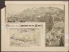
Territorium Abbatiae Heresfeldensis. 't Stift Hirßfeldt. [Karte], in: Theatrum orbis terrarum, sive, Atlas novus, Bd. 1, S. 242.
1 Karte aus Atlas Blaeu, Joan Blaeu, Willem Janszoon
TERRITORIVM | ABBATIÆ HERESFEL- | DENSIS. | 't Stift | Hirszfeldt.
Apud Guiljelmum Blaeu.
Abbatia Heresfeldensis vulgo t'Stifft Hirsfeldt
1 : 60000 Mollova mapová sbírka Schenk, Pieter Schenk, Peter I
Abbatia Heresfeldensis vulgo t'Stifft Hirsfeldt
1 : 60000 Mollova mapová sbírka Blaeu, Willem Janszoon Blaeu, Willem Jansz.
Abbatia Heresfeldensis vulgo t'Stifft Hirsfeldt
1 : 60000 Mollova mapová sbírka Hondius, Henricus Hondius, Henricus
Gefechte bei Zella und Rossdorf, 4.Juli 1866
1 : 25000 Topograph. Bureau des k.b. Generalquartiermeister-Stabes
Gefecht bei Hünfeld
1 : 25000 Huber, J.; Popp, A.; Hoffmann, C.
Meßtischblatt 5427 : Helmershausen, 1940
1 : 250000 Helmershausen. - Aufn. 1904, hrsg. 1906. - 1:25000. - [Berlin]: Reichsamt für Landesaufnahme, 1940. - 1 Kt.
Meßtischblatt 3175 . Helmershausen, 1906
1 : 250000 Helmershausen. - Aufn. 1904. - 1:25000. - [Berlin]: Kgl. Preuss. Landesaufnahme, 1906. - 1 Kt.
Meßtischblatt 3175 : Helmershausen, 1878
1 : 250000 Helmershausen. - Aufn. 1857, hrsg. 1874, bericht. 1878. - 1:25000. - [Berlin]: Kgl. Preuss. Min. f. Handel, 1878. - 1 Kt.
Meßtischblatt 5426 : Hilders, 1953
1 : 250000 Hilders. - Hrsg. 1906, letzte Nachtr. 1936, redakt. Änd. 1953 . - 1:25000. - [Berlin]: MdI, 1953. - 1 Kt.
Meßtischblatt 3174 : Hilders, 1906
1 : 250000 Hilders. - Aufn. 1904. - 1:25000. - [Berlin]: Reichsamt für Landesaufnahme, 1906. - 1 Kt.
Meßtischblatt 3173 : Kleinsassen, 1907
1 : 250000 Kleinsassen. - Aufn. 1905. - 1:25000. - [Berlin]: Kgl. Preuss. Landesaufnahme, 1907. - 1 Kt.
Meßtischblatt 3172 : Fulda, 1907
1 : 250000 Fulda. - Aufn. 1905. - 1:25000. - [Berlin]: Kgl. Preuss. Landesaufnahme, 1907. - 1 Kt.
Meßtischblatt 3171, neue Nr. 5423 : Großenlüder, 1936
1 : 250000 Großenlüder. - Hrsg. 1907, bericht. 1910, einzelne Nachtr. 1930. - 1:25000. - [Berlin]: Reichsamt für Landesaufnahme, 1936. - 1 Kt.
Meßtischblatt Hosenfeld
1 : 250000 Hosenfeld. - Aufn. 1906. - 1:25000. - [Berlin]: Kgl. Preuss. Landesaufnahme, 1908. - 1 Kt.
Meßtischblatt 5327 : Oepfershausen, 1936
1 : 250000 Oepfershausen. - Hrsg. 1907, einz. Nachtr. 1927. - 1:25000. - [Berlin]: Reichsamt für Landesaufnahme, [19]36. - 1 Kt.
Meßtischblatt 3116 : Oepfershausen, 1919
1 : 250000 Oepfershausen. - Aufn. 1905, hrsg. 1907, Aufldr. 1919. - 1:25000. - [Berlin]: Reichsamt für Landesaufnahme, 1919. - 1 Kt.
Meßtischblatt 5327 : Tann, 1936
1 : 250000 Tann. - Hrsg. 1907, einz. Nachtr. 1936. - 1:25000. - [Berlin]: Reichsamt für Landesaufnahme, 1936. - 1 Kt.
Meßtischblatt 3115 : Tann, 1910
1 : 250000 Tann. - Aufn. 1905, hrsg. 1907, einz. Nachtr. 1910. - 1:25000. - [Berlin]: Reichsamt für Landesaufnahme, 1910. - 1 Kt.
Meßtischblatt 3115 : Tann, 1907
1 : 250000 Tann. - Aufn. 1905. - 1:25000. - [Berlin]: Kgl. Preuss. Landesaufnahme, 1907. - 1 Kt.