Maps of Alsfeld
Section Alsfeld
Eckhardt, Christian Leonhard Philipp; Haas, Johann Heinrich; Meister, G.; Klos
Meßtischblatt 3049 : Lingelbach, 1908
1 : 250000 Lingelbach. - Aufn. 1906. - 1:25000. - [Berlin]: Kgl. Preuss. Landesaufnahme, 1908. - 1 Kt.
Meßtischblatt 5122 : Neukirchen i. Hessen-Nassau,1941
1 : 250000 Neukirchen i. Hessen-Nassau. - Hrsg. 1908, letzte Nachtr. 1939, Ausg. 1941. - 1:25000. - [Berlin]: Reichsamt für Landesaufnahme, 1941. - 1 Kt.
Ungefährlicher Entwurf den Ämbter Alssfeldt, Rümrodt, Grebenau, der Gerichte Schwarz und von Süsser Gerichte
1 : 35000 [S.l. : s.n.]
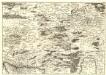
Bewegungen der Alliirten, und Französischen Armee zwischen dem 19ten und 21ten März 1761, nebst Aufstellung und Rückzug der Alliirten am 23ten und 24ten

Meßtischblatt 5219 : Amöneburg, 1937
1 : 250000 Amöneburg. - Hrsg. 1908, einzelne Nachtr. 1937. - 1:25000. - [Berlin]: Reichsamt für Landesaufnahme, 1937. - 1 Kt.
Meßtischblatt 5119 : Kirchhain (Hessen-Nassau), 1942
1 : 250000 Kirchhain (Hessen-Nassau). - Hrsg. 1908, letzte Nachtr. 1937, Ausg. 1942. - 1:25000. - [Berlin]: Reichsamt für Landesaufnahme, 1942. - 1 Kt.
Landgrafiatvs Hasso-Cassellanvs typo geographico quatuor Foliorum expressus Cura Homannianorum Heredum Norimb: 1761
1 : 160000 Mollova mapová sbírka Homann, Johann Baptist Homann, Johann Baptista - dědici
Delineatio Geographica generalis comprehendens VI. Foliis Singulos Principatvs Comitatvs Ditiones Dynastias omnes quotquot Imperio Serenissimi Principis Landgrafii Hasso-Darmstadiensis subsunt :
1 : 180000 Mollova mapová sbírka Bronner, Christian Maximilian Homann, Johann Baptista - dědici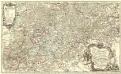
Partie Méridionale du Langraviat de Hesse-Cassel avec une Partie de la Vetteravie
1 : 200000 Mollova mapová sbírka Carlet, Louis-François Coentgen, Heinrich Hugo Broenner, Heinrich Ludwig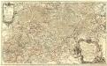
Partie Méridionale du Langraviat de Hesse-Cassel avec une Partie de la Vetteravie
1 : 200000 Mollova mapová sbírka Carlet, Louis-François Coentgen, Heinrich Hugo Broenner, Heinrich Ludwig
Partie méridionale du langraviat de Hesse-Cassel
Hesensko (Německo) Carlet, Louis-François Broglie, Victor-François de chez Henrii Louis Broenner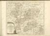

Vestrovaldia ad septentrionem sita in IV. mappis geogr. proposita cum adiac. regionibus cum plurim. privil
1 : 171000 Fulda (Německo) Buna, Wilhelm C. Reinhardt, Andreas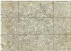
[La baße partie du cercle du Haut-Rhein, divisé en tous ses etats et souverainetes, ou sont le landgraviat de Hesse, les Abbayes de Fulde, et d' Hirschfeld, avec les seigneuries de Wetteravie] et une partie de Westerwald
1 : 171000 Bad Hersfeld (Německo) Buna, Wilhelm C.
Vestrovaldia ad Septentrionem sita in IV. Mappis Geogr: Proposita cum adiac: Regionibus. cum Plurim: Privil:
1 : 210000 Mollova mapová sbírka Buna, Wilhelm C. Broenner, Heinrich Ludwig
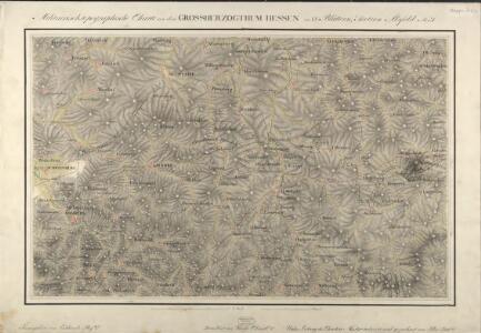
Uebersichts-Karte des Oberfürstenthums Hessen
Meister, G.
Landgraviatus Hassiae Inferioris Comitatvs Waldeciae Eichsfeldiae Tabvla Geographica
1 : 140000 Mollova mapová sbírka Berger, Daniel
Hassia Landgraviatus
1 : 350000 Mollova mapová sbírka Hondius, Henricus Janssonius, Johannes I
Hassiae Svperioris et Wetterav. Partis Delineatio
1 : 170000 Mollova mapová sbírka Bronner, Christian Maximilian Homann, Johann Baptista - dědici
Eisenach 86, uit: Special-Karte von Mittel-Europa / nach amtlichen Quellen bearbeitet von W. Liebenow
1 : 300000 titelvariant: W. Liebenow's Mittel-Europa; Annotatie: Titel boven de bladen: W. Liebenow's Mittel-Europa Johannes Wilhelm Liebenow 1822-1897 Frankfurt a. M. : Ludwig Ravenstein
Cassel
1 : 300000 R. Mittelbach
S. R. Imp. Circuli Franconici Geographica Delineatio Francken-Land mit Seinen Gräntzen
Mollova mapová sbírka Endter, Wolfgang Moritz Endter, Wolfgang Moritz
Buchaviae, sive Fuldensis Ditionis Typus. [Karte], in: Theatrum orbis terrarum, S. 144.
1 Karte aus Atlas Ortelius, Abraham
125. Marburg, uit: Topographische Uebersichtskarte des Deutschen Reiches / herausgegeben v. d. Kartogr. Abt. d. Königl. Preuß. Landesaufnahme
1 : 200000 titelvariant: Topogr. Übersichtskarte des Deutschen Reiches; Annotatie: Titel boven bladen ook: Topogr. Übersichtskarte des Deutschen Reiches; Annotatie geografische gegevens: Op elk blad twee maatstokken: 10 Kilometer = 5,5 cm; 1 geogr. Meile = 3,6 cm; Legenda onder op elk blad Königlich Preußische Landesaufnahme. Kartographische Abtheilung [S.l : Königlich Preußische Landesaufnahme, Kartographische Abtheilung]
Eisenach 86, uit: [W. Liebenow's Special-Karte von Mittel-Europa]
1 : 300000 titelvariant: W. Liebenow's Mittel-Europa; Annotatie: Titel boven de bladen: W. Liebenow's Mittel-Europa Johannes Wilhelm Liebenow 1822-1897 Hannover : Hermann Oppermann
Section Giessen, uit: Charte von dem Grossherzogtum Hessen und dem Herzogtum Nassau / trigonometrisch aufgenommen und hrsg. von C.L.P. Eckhardt
1 : 200000 titelvariant: Karte von Hessen und Nassau Eckhardt, C. L. P Darmstadt : Joh. Wilh. Heyer
Le Landgraviat de Hesse-Cassel Meridional et Septentr: avec une Partie du Landgraviat de Hesse-Darmstat et de la Vetteravie avec autres dependences
1 : 200000 Mollova mapová sbírka Carlet, Louis-François Lotter, Tobias Conrad