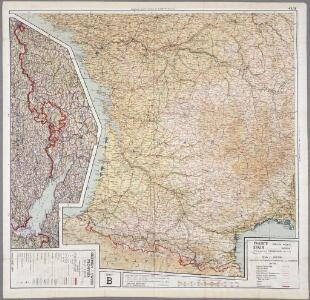
Maps of New Aquitaine

43 Sheet B, uit: France (North West), Belgium (West and Central), Holland (part of) ; France (South West), Spain (North)
1 : 1000000 [London : MI9]
France Régionale Bassin d’Aquitaine Massif Central - Pyrénées carte politique
Gallois, Lucien
France Régionale Bassin d’Aquitaine Massif Central - Pyrénées carte physique
Gallois, Lucien
Carte générale des fleuves, des rivieres, et des principaux ruisseaux de la France, 2
1 Blatt : chez l'auteur Dupain-Triel
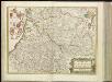
Aquitania australis Regnum Arelatense cum confiniis [Karte], in: Gerardi Mercatoris et I. Hondii Newer Atlas, oder, Grosses Weltbuch, Bd. 2, S. 125.
1 Karte aus Atlas Mercator, Gerhard und Hondius, Jodocus Jansson, Jan
Carte de la France suivant sa nouvelle division en departements et disricts, 2
2 Blätter : 63 x 117 cm s.n.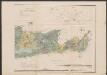
Aquitania australis Regnum Arelatense cum confiniis. [Karte], in: Gerardi Mercatoris Atlas, sive, Cosmographicae meditationes de fabrica mundi et fabricati figura, S. 226.
1 Karte aus Atlas Mercator, Gerhard Montanus, Petrus
A new an exact map of ey south west part of France
1 : 957000 Berry (Francie) Picard, Jean La Hire, Philippe de
France
[14][14] Gouvernement de la Guienne & Gascogne, uit: Atlas sive Descriptio terrarum orbis
Annotatie: Gedigitaliseerde versie. Amsterdam. Heiloo : Picturae (vervaardiger), 2015. tiff-bestand. Gedigitaliseerd: 07-01-2015; Origineel: Universiteitsbibliotheek Vrije Universiteit (XL.05127.-) ; Netherlands; Titelpagina ontbreekt Wit, Frederik de Amsterdam : Frederick de Wit
Postkarte von Frankreichs südwestlichen Departements oder von Gasconien und Poitou
Gaskoňsko (Francie) Engelmann, Johann Wenzel im von Reillyschen Landkarten und Kunstwerke Verschleiss Komptoir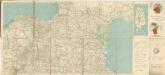
Carte Michelin – Les Grandes Routes de France

Aqvitania australis regnv[m] Arelatense cum confinijs
1 Karte : Kupferdruck ; 33 x 45 cm Mercator; Hondius Henricus Hondius
Aqvitania australis regnv[m] Arelatense cum confinijs
1 Karte : Kupferdruck ; 34 x 45 cm Hondius; Mercator Jodocus Hondius
Aqvitania australis regnv[m] Arelatense cum confinijs
1 Karte : Kupferdruck ; 33 x 45 cm Mercator s.n.
Partie, la France. Europe 19.
1 : 1641836 Vandermaelen, Philippe, 1795-1869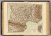
France S., Corsica.
1 : 1750000 Andree, Richard; Times (London, England)
France II.
1 : 1770000 Society for the Diffusion of Useful Knowledge (Great Britain)
35-36. Francia sud.
1 : 1500000 Touring club italiano
Reisekarte von Süd - Frankreich

Frankreich SW.
1 : 1700000 Berghaus, Heinrich; Flemming, Carl; Handtke, Friedrich H.; Sohr, Karl
[Frankreich in 4 Blättern, Blatt 3]
Handatlas über alle Theile der Erde und über das Weltgebäude Stieler, Adolf Justus Perthes
[Frankreich, Blatt 3]
Adolf Stieler's Handatlas über alle Theile der Erde und über das Weltgebäude Stieler, Adolf Justus Perthes

Frankreich In 4 Blattern. Blatt 3.
1 : 1500000 Vogel, C.
Le royaume d'Aquitaine
1 Karte : Kupferdruck ; 40 x 49 cm, Bildgrösse 41 x 56 cm Duval chez l'auteur en l'isle du Palais sur le quay de l'Orloge au coin de la rüe de Harlay
Gouvernement de la Guienne & Gascogne / [Joan Blaeu]
1 : 900000 Annotatie: Oorspr. verschenen in: Geographiae Blavianae volumen septimum ... - Amstelaedami : labore & sumptibus Ioannis Blaeu, 1662; Origineel is Blad 17 in atlas factice Blaeu, Joan [Amsterdam : Joan Blaeu]
Aqvitaniæ descriptio
1 Karte : Kupferdruck ; 17 x 23 cm Mercator Cloppenburgh
Tabula Aquitaniae complectens gubernationem Guiennae et Vasconiae
1 : 800000 exhibita a Joh. Bapt. Homanno Norimbergae : [Johann Baptist Homann]