Maps of New Aquitaine

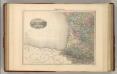
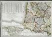
[Frankreich in 4 Blättern, Blatt 3]
Handatlas über alle Theile der Erde und über das Weltgebäude Stieler, Adolf Justus Perthes
[Frankreich, Blatt 3]
Adolf Stieler's Handatlas über alle Theile der Erde und über das Weltgebäude Stieler, Adolf Justus Perthes
Frankreich In 4 Blattern. Blatt 3.
1 : 1500000 Vogel, C.
Frankreich SW.
1 : 1700000 Berghaus, Heinrich; Flemming, Carl; Handtke, Friedrich H.; Sohr, Karl
France S.O.
1 : 1615000 Migeon, J.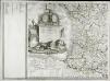
Carte de la France, 3
1 Blatt : 61 x 83 cm de Belleyme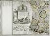
Carte de la France, 3
1 Blatt : mehrfarbig ; 61 x 83 cm de Belleyme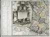
Carte de la France, 3
1 Blatt : 61 x 82 cm de Belleyme
[Frankreich in 4 Blättern, Südwestliches Frankreich]
Hand-Atlas über alle Theile der Erde und über das Weltgebäude Stieler, Adolf Justus Perthes
Le royaume d'Aquitaine
1 Karte : Kupferdruck ; 40 x 49 cm, Bildgrösse 41 x 56 cm Duval chez l'auteur en l'isle du Palais sur le quay de l'Orloge au coin de la rüe de Harlay
Le royaume de France, 4
1 Blatt : 47 x 45 cm Jaillot
France
Carte de la république de France, no. 5
1 Blatt : 42 x 59 cm s.n.
A new an exact map of ey south west part of France
1 : 957000 Berry (Francie) Picard, Jean La Hire, Philippe de
Carte de la France (SO)
1 : 345600 Cassini family
France.
1 : 4400000 Vivien de St Martin, L.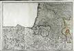
Neueste Generalkarte von Frankreich, 5
1 Blatt : 54 x 78 cm F.A. Schrämbl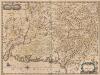
Description Du Guienne. [Karte], in: Novus atlas absolutissimus, Bd. 4, S. 156.
1 Karte aus Atlas Janssonius Offizin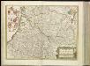
[14][14] Gouvernement de la Guienne & Gascogne, uit: Atlas sive Descriptio terrarum orbis
Annotatie: Gedigitaliseerde versie. Amsterdam. Heiloo : Picturae (vervaardiger), 2015. tiff-bestand. Gedigitaliseerd: 07-01-2015; Origineel: Universiteitsbibliotheek Vrije Universiteit (XL.05127.-) ; Netherlands; Titelpagina ontbreekt Wit, Frederik de Amsterdam : Frederick de Wit

France Régionale Bassin d’Aquitaine Massif Central - Pyrénées carte physique
Gallois, Lucien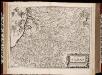
Gouvernement de la Guienne & Gascogne / [Joan Blaeu]
1 : 900000 Annotatie: Oorspr. verschenen in: Geographiae Blavianae volumen septimum ... - Amstelaedami : labore & sumptibus Ioannis Blaeu, 1662; Origineel is Blad 17 in atlas factice Blaeu, Joan [Amsterdam : Joan Blaeu]
France Régionale Bassin d’Aquitaine Massif Central - Pyrénées carte politique
Gallois, Lucien
GOVVERNEMENT | DE | LA GVIENNE | & GASCOGNE.
[Amsterdam : Joan Blaeu]

Carte de la République française, 3
1 Blatt : 42 x 50 cm P.G. Chanlaire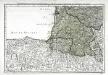
Cinquieme feuille contenant la Guienne, le Bearn, la Basse Navarre, le comté de Foix, et une partie du Languedoc
1 Blatt : 38 x 54 cm Bourgoin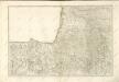

![[Frankreich in 4 Blättern, Blatt 3]](https://images-2.georeferencer.com/images/iiif/134798016467/full/,300/0/native.jpg)

