Maps of New Aquitaine

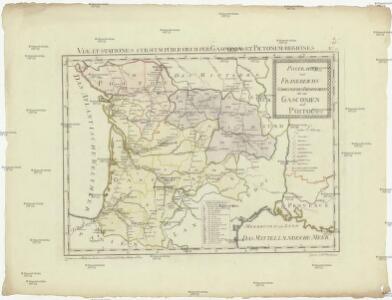
Postkarte von Frankreichs südwestlichen Departements oder von Gasconien und Poitou
Gaskoňsko (Francie) Engelmann, Johann Wenzel im von Reillyschen Landkarten und Kunstwerke Verschleiss Komptoir
Aqvitania australis regnv[m] Arelatense cum confinijs
1 Karte : Kupferdruck ; 33 x 45 cm Mercator; Hondius Henricus Hondius
Aqvitania australis regnv[m] Arelatense cum confinijs
1 Karte : Kupferdruck ; 34 x 45 cm Hondius; Mercator Jodocus Hondius
Aqvitania australis regnv[m] Arelatense cum confinijs
1 Karte : Kupferdruck ; 33 x 45 cm Mercator s.n.
Aquitania australis Regnum Arelatense cum confiniis [Karte], in: Gerardi Mercatoris et I. Hondii Newer Atlas, oder, Grosses Weltbuch, Bd. 2, S. 125.
1 Karte aus Atlas Mercator, Gerhard und Hondius, Jodocus Jansson, Jan
France S., Corsica.
1 : 1750000 Andree, Richard; Times (London, England)
Partie, la France. Europe 19.
1 : 1641836 Vandermaelen, Philippe, 1795-1869
France II.
1 : 1770000 Society for the Diffusion of Useful Knowledge (Great Britain)
France Régionale Bassin d’Aquitaine Massif Central - Pyrénées carte politique
Gallois, Lucien
43 Sheet B, uit: France (North West), Belgium (West and Central), Holland (part of) ; France (South West), Spain (North)
1 : 1000000 [London : MI9]
Carte Michelin – Les Grandes Routes de France

France Régionale Bassin d’Aquitaine Massif Central - Pyrénées carte physique
Gallois, Lucien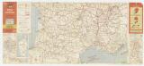
Etat des routes : hôtels, bonnes tables, mécaniciens, routes enneigées
1 : 1000000 Annotatie: Met aansluitende bijkaart van Corsica Paris : Services de Tourisme Michelin
35-36. Francia sud.
1 : 1500000 Touring club italiano
France 3.
1 : 1774080 Letts, Son & Co.
Reisekarte von Süd - Frankreich
[14][14] Gouvernement de la Guienne & Gascogne, uit: Atlas sive Descriptio terrarum orbis
Annotatie: Gedigitaliseerde versie. Amsterdam. Heiloo : Picturae (vervaardiger), 2015. tiff-bestand. Gedigitaliseerd: 07-01-2015; Origineel: Universiteitsbibliotheek Vrije Universiteit (XL.05127.-) ; Netherlands; Titelpagina ontbreekt Wit, Frederik de Amsterdam : Frederick de Wit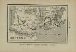
Marche des Visigoths en Gaule
Frankreich Gallien Westgoten Völkerwanderungszeit Völkerwanderung
A new an exact map of ey south west part of France
1 : 957000 Berry (Francie) Picard, Jean La Hire, Philippe de
Carte internationale du monde au 1,000,000 E
1 : 1000000 Lyon (Francie) Service Géographique de l'Armée
Carte internationale de l'Empire Romain au 1:1,000,000 E
1 : 1000000 Lyon (Francie) Service Géographique de l'Armée
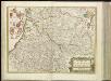
Govvernement general de Gvienne et Gvascogne et pays circonvoisins
1 Karte : Kupferdruck ; 39 x 53 cm Sanson; Peyrounin chez l'auteur
France - south-western section; Bordeaux.
1 : 1000000 John Bartholomew & Co.
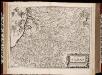
Carte de Guienne et Gascogne
1 Karte auf 4 Blatt : Kupferdruck ; 79 x 89 cm Mondhare; Jean chez Mondhare et Jean rue St. Jean de Beauvais no. 4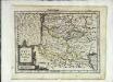
Aqvitaniæ descriptio
1 Karte : Kupferdruck ; 17 x 23 cm Mercator Cloppenburgh
Tabula Aquitaniae complectens gubernationem Guiennae et Vasconiae
1 : 800000 exhibita a Joh. Bapt. Homanno Norimbergae : [Johann Baptist Homann]
Gouvernement de la Guienne & Gascogne / [Joan Blaeu]
1 : 900000 Annotatie: Oorspr. verschenen in: Geographiae Blavianae volumen septimum ... - Amstelaedami : labore & sumptibus Ioannis Blaeu, 1662; Origineel is Blad 17 in atlas factice Blaeu, Joan [Amsterdam : Joan Blaeu]