Maps of Hampshire

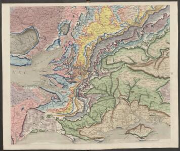
delineation of the strata of England and Wales, with part of Scotland
1 : 320000 Blatt 10 Smith, William Cary
Ordnance Survey of England and Wales (Aeronautical map)
Great Britain. War Office. General Staff. Geographical Section [London] : [Air Ministry],
England and Wales 1:253,440
Ordnance Survey
England south
1 : 253440 Anglie jižní Ordnance Survey Office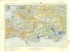
England and Wales[OS civil air edition]
Ordnance Survey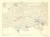
Britain, defences South of England and Wales
[London] : Ministry of Home Security
Sheet 11 England, South, uit: Maps of England & Wales : scale 4 miles to 1 inch / Ordnance Survey
1 : 253440 titelvariant: Maps of England and Wales; Annotatie: Titel op cassette; Met bladoverzicht op de achterzijde van de cassette; Annotatie geografische gegevens: Hoogtelijneninterval 200 ft Ordnance Survey, United Kingdom Southampton : Ordnance Survey Office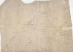
Southern England
1 : 21120 Triangulation allows the relative location of individual topographical features to be plotted accurately. This drawing shows the primary triangulation of southern England, the lengths of the sides of each triangle being noted. Stations shown include Dunnose, Bagshot Heath, Inkpen Hill and the Salisbury Plain base. The points of the triangles provided the surveyor with references to which, by measurement or angular observation, he could precisely relate the position of other topographical features. Angular observations were made using a theodolite. Triangulation points were carefully chosen. Elevated sites were preferred where possible, particularly the tops of hills and church towers.
Wiltonia sive Comitatus Wiltoniensis. Anglis Wil Shire. [Karte], in: Novus atlas absolutissimus, Bd. 7, S. 170.
1 Karte aus Atlas Janssonius Offizin
Hantoniae Comitatus cum Bercheria. [Karte], in: Novus atlas absolutissimus, Bd. 7, S. 153.
1 Karte aus Atlas Janssonius Offizin
Hantoniae comitatus cum Berchia
1 : 240000 Amstelodami : apud Joannem Janssonium
Wiltonia sive Comitatus Wiltoniensis; Anglis Wil Shire. [Karte], in: Theatrum orbis terrarum, sive, Atlas novus, Bd. 4, S. 163.
1 Karte aus Atlas Blaeu, Joan Blaeu, Willem Janszoon
Wiltonia sive Comitatus Wiltoniensis; Anglis Wil Shire. [Karte], in: Theatrum orbis terrarum, sive, Atlas novus, Bd. 4, S. 163.
1 Karte aus Atlas Blaeu, Joan Blaeu, Willem Janszoon
Wiltonia sive Comitatus Wiltoniensis; Anglis Wilshire. [Karte], in: Le théâtre du monde, ou, Nouvel atlas contenant les chartes et descriptions de tous les païs de la terre, Bd. 4, S. 145.
1 Karte aus Atlas Blaeu, Willem Janszoon und Blaeu, Joan Blaeu, Willem Janszoon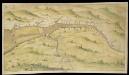
Bristol Channel and Severn Estuary
This is a chart showing the Bristol Channel and the River Severn. Sandbanks in the River Severn are indicated by stippling and the draughtsman has indicated the ‘Channell betweene the groundes’. The tributries of the Severn are indicated and figures along the banks record the distance in miles between their mouths. Locations of note, such as Bristol, Bath and Newport are represented by generalised perspective views of houses and churches. The map is thought to date from 1595, reflecting the fear that the Spanish were planning to invade the Bristol Channel in the 1590’s, rather than initiate a more obvious and direct attack via the English Channel. The Anglo- Spanish relationship had steadily deteriorated since the accession of the Protestant Elizabeth I. Raids on transatlantic shipping by English seamen such as Francis Drake and England’s support of the Protestant rebellion in the Spanish ruled Netherlands had brought tensions with Spain to a crescendo culminating in the events of the Spanish Armada. Although the Spanish Armada was defeated by the English in 1588, England remained at war with Spain for many years and further attempts to invade were made by Philip II. In 1595, the year this chart was produced, the Spanish attacked Mounts Bay, Newlyn and Penzance.
Hantoniæ comitatus cum Bercheria
1 Karte : Kupferdruck ; 42 x 53 cm Valck; Schenk apud G. Valk et P. Schenk
Sheets 13-14. (Cary's England, Wales, and Scotland).
1 : 360000 Cary, John, ca. 1754-1835
WILTONIAE
This map of Wiltshire is from the 1583 edition of the Saxton atlas of England and Wales. TThis atlas was first published as a whole in 1579. It consists of 35 coloured maps depicting the counties of England and Wales. The atlas is of great significance to British cartography as it set a standard of cartographic representation in Britain and the maps remained the basis for English county mapping, with few exceptions, until after 1750. During the reign of Elizabeth I map use became more common, with many government matters referring to increasingly accurate maps with consistent scales and symbols, made possible by advances in surveying techniques. Illustrating the increasing used of maps in government matters, Lord Burghley, Elizabeth I’s Secretary of State, who had been determined to have England and Wales mapped in detail from the 1550s, selected the cartographer Christopher Saxton to produce a detailed and consistent survey of the country. The financier of the project was Thomas Seckford Master of Requests at the Court of Elizabeth I, whose arms appear, along with the royal crest, on each map. Saxton’s name appears in the decorative scale bar as does the name of the engraver of this map, Remigius Hogenberg ,one of seven English and Flemish engravers employed to produced the copper plates for the atlas. Relief, in the form of uniform rounded representations of hills, is the main topographical feature presented in the maps. Rather than provide a scientific representation of relative relief these give a general impression of the lie of the land. Settlements and notable buildings are also recorded pictorially; a small building with a spire represents a village, while more important towns are indicated by groups of buildings. Here Stonehenge is marked by a pictorial representation and named The Stonadge’. Saxton, Christopher Ryther, Augustine
A new travelling map of the country round London, 3
1 Blatt : 49 x 61 cm J. Andrews & A. Drury
Sheets 23-24. (Cary's England, Wales, and Scotland).
1 : 360000 Cary, John, ca. 1754-1835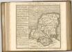

SOUTHAMPTONIA
This map of Hampshire is from the 1583 edition of the Saxton atlas of England and Wales.This atlas was first published as a whole in 1579. It consists of 35 coloured maps depicting the counties of England and Wales. The atlas is of great significance to British cartography as it set a standard of cartographic representation in Britain and the maps remained the basis for English county mapping, with few exceptions, until after 1750. During the reign of Elizabeth I map use became more common, with many government matters referring to increasingly accurate maps with consistent scales and symbols, made possible by advances in surveying techniques. Illustrating the increasing used of maps in government matters, Lord Burghley, Elizabeth I’s Secretary of State, who had been determined to have England and Wales mapped in detail from the 1550s, selected the cartographer Christopher Saxton to produce a detailed and consistent survey of the country. The financier of the project was Thomas Seckford Master of Requests at the Court of Elizabeth I, whose arms appear, along with the royal crest, on each map. Saxton, Christopher Ryther, Augustine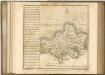
Cary's Traveller's Companion, or, a Delineation of the Turnpike Roads of England and Wales
London : G. & J. Cary
A new improved map of Hampshire
1 Karte : Kupferdruck ; 51 x 67 cm Kitchin; Hinton sold by I. Hinton at the Kings Arms in St. Pauls Church Yard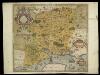
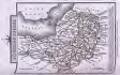
SOUTHAMPTONIAE Comitatus
This is a map of Hampshire by Christopher Saxton, datingfrom 1575. It forms part of an atlas that belonged to William Cecil Lord Burghley, Elizabeth I’s Secretary of State. Burghley used this atlas to illustrate domestic matters. This map is actually a proof copy of one which forms part of Christopher Saxton’s Atlas of England and Wales. This atlas was first published as a whole in 1579. It consists of 35 coloured maps depicting the counties of England and Wales. The atlas is of great significance to British cartography as it set a standard of cartographic representation in Britain and the maps remained the basis for English county mapping, with few exceptions, until after 1750. During the reign of Elizabeth I, map use became more common, with many government matters referring to increasingly accurate maps with consistent scales and symbols, made possible by advances in surveying techniques. Illustrating the increasing use of maps in government matters, Lord Burghley, who had been determined to have England and Wales mapped in detail from the 1550s, selected the cartographer Christopher Saxton to produce a detailed and consistent survey of the country. The financier of the project was Thomas Seckford, Master of Requests at the Court of Elizabeth I, whose arms appear, along with the royal crest, on each map. Lord Burghley added several place names to the map. This map was engraved by Leonardus Terwoort, one of a team of seven English and Flemish engravers employed to produced the copper plates for the atlas. Saxton, Christopher Terwoort, Leonardus Antverpianus
Glocestria Ducatus; Vulgo Glocester Shire. [Karte], in: Theatrum orbis terrarum, sive, Atlas novus, Bd. 4, S. 228.
1 Karte aus Atlas Blaeu, Joan Blaeu, Willem Janszoon
Glocestria Ducatus; Vulgo Glocester Shire. [Karte], in: Theatrum orbis terrarum, sive, Atlas novus, Bd. 4, S. 228.
1 Karte aus Atlas Blaeu, Joan Blaeu, Willem Janszoon