Maps of Swabia

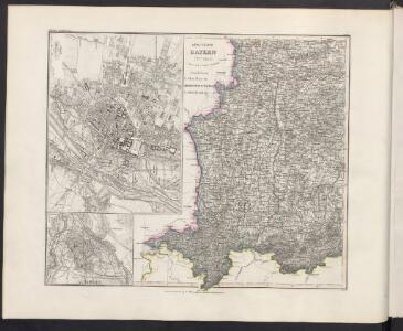
Königreich Bayern
Grosser Hand-Atlas über alle Theile der Erde in 170 Karten Meyer, J. Verlag des Bibliographischen Instituts
Bayern III.
1 : 650000 Radefeld, Carl Christian Franz, 1788-1874
Die Markgrafschaft Burgau mit den Grafschaften Kirchberg und Weissenhorn
1 Karte : Kupferdruck ; 21 x 23 cm Reilly F. J. J. von Reilly
Episcopatus Avgvstanvs compendio
1 : 630000 Mollova mapová sbírka Glasser, Johann Friedrich Mayr, Johann L. Glasser, Johann Friedrich
Geographica Sueviæ universæ descriptio, 4
2 Blätter : Homännische Erben

Alemannia Sive Suevia Superior [Karte], in: Novus Atlas, das ist, Weltbeschreibung, Bd. 1, S. 237.
1 Karte aus Atlas Blaeu, Joan Blaeu, Willem Janszoon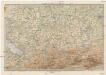
Karte der Bayrischen und Algäuer Alpen
1 : 250000 Allgäuské Alpy (Německo a Rakousko) Ravenstein, Ludwig L. Ravenstein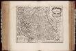
Alemannia sive Svevia svperior / a Christophoro Hurtero
1 : 500000 Annotatie: Origineel is Blad 120 in atlas factice; Annotatie geografische gegevens: Schaalstokken op kaart: Milliaria Alemanica quorum 12 um gradui respondent, en: Milliaria Germanica communia; West boven; Legenda linksonder: Expositio notarum Johann Christoph Hurter; Willem Jansz Blaeu 1571-1638 [Amsterdami] : [apud Guiljelmum Blaeu]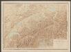
Nova Alemanniae Sive Sueviae Superioris Tabula. [Karte], in: Gerardi Mercatoris et I. Hondii Newer Atlas, oder, Grosses Weltbuch, Bd. 1, S. 241.
1 Karte aus Atlas Mercator, Gerhard und Hondius, Jodocus Jansson, Jan
Nova Alemanniæ sive Sveviæ svperioris tabvla
1 Karte : Kupferdruck ; 36 x 47 cm Valck; Schenk apud G. Valk et P. Schenk
Alemannia sive Suevia Superior
Hurter, Christoph
Nova Alemanniae sive Sveviae Svperioris Tabvla
Hondius, Henricus
Alemannia Sive Suevia Superior [Karte], in: Le théâtre du monde, ou, Nouvel atlas contenant les chartes et descriptions de tous les païs de la terre, Bd. 1, S. 266.
1 Karte aus Atlas Blaeu, Willem Janszoon und Blaeu, Joan Blaeu, Willem Janszoon
Alemannia Sive Suevia Superior [Karte], in: Theatrum orbis terrarum, sive, Atlas novus, Bd. 1, S. 280.
1 Karte aus Atlas Blaeu, Joan Blaeu, Willem Janszoon
Nova Alemanniae Sive Sueviae Superioris Tabula. [Karte], in: Novus atlas absolutissimus, Bd. 2, S. 217.
1 Karte aus Atlas Janssonius Offizin
Sacri Imperii Romani Circuli et Electoratus Bavariae cum Finitimis Geographica Descriptio. Cum Privilegio D.D. Ordinum Generalium ut et Hollandiae West Frisiaequae]
1 : 270000 Mollova mapová sbírka Valck, Leonardus
Alemannia sive Svevia Svperior
1 : 480000 Mollova mapová sbírka Hurter, Johann Christoph Blaeu, Joan I.
Nova Alemanniae sive Svevia Svperioris Tabvla
1 : 490000 Mollova mapová sbírka Hurter, Johann Christoph Janssonius, Johannes I
Alemaniae sive Sveviae Svperioris Chorographia nova
1 : 310000 Mollova mapová sbírka Hurter, Johann Christoph Custos, Raphael
Totius s.r.i. circuli Suevici tabula chorographica, 4
1 Blatt : R. et J. Ottens
Freytag & Berndt ́s: Auto-Strassenkarten

ALEMANNIA | SIVE | SVEVIA SVPERIOR
A. Christophoro Hurtero. [Amsterdam : Joan Blaeu]
Partie meridionale de la Souabe
1 Karte : Kupferdruck ; 46 x 65 cm L'Isle; Ottens; Ottens chez R. et I. Ottens geogr
Der Lech-Fluss von Füessen im Algöw an, bis zu seinen Auslauff in die Donaw
Německo Bodenehr, Gabriel G. Bodenehr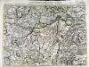
Carte topographique d'Allemagne contenant une partie de Baviere les principautés de Wurtemberg, d'Oettingen
1 Karte : Kupferdruck ; 45 x 63 cm Jaeger se vend chez l'auteur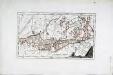
Das Bisthum Augsburg mit der freyen Reichsstadt Augsburg
1 Karte : Kupferdruck ; 31 x 18 cm Reilly F. J. J. von Reilly
Militair Karte von Süd-Deutschland in 20 Sectionen
1 : 400000 14. Section Coulon, Alois von A. von Coulon
Carte topographique d'Allemagne contenant une partie de Bavére, de Suabe, du comté de Tirol et de l'évêché d'Augspourg, l'Algow, les quatre seigneuries autrichienne devant la montagne d'Arlenberg
1 Karte fait par I. W. Iaeger chez l'auteur, Francfort sur le Mein