Maps of Swabia
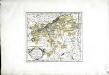
Die Markgrafschaft Burgau mit den Grafschaften Kirchberg und Weissenhorn
1 Karte : Kupferdruck ; 21 x 23 cm Reilly F. J. J. von Reilly
Circvli Sveviae mappa
1 : 490000 Švábsko (Německo) Hase, Johann Matthias Michaliani editum opera Homan[n]ianorum Heredum
Circvli Sveviae mappa
1 : 490000 Švábsko (Německo) Hase, Johann Matthias Michaliani editum opera Homan[n]ianorum Heredum
Circvli Sveviae mappa
1 : 490000 Švábsko (Německo) Hase, Johann Matthias editum opera Homan[n]ianorum Heredum
Circvli Sveviae mappa
1 : 490000 Švábsko (Německo) Hase, Johann Matthias Michaliani editum opera Homan[n]ianorum Heredum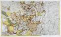
Geographica Sueviæ universæ descriptio, 4
2 Blätter : Homännische Erben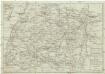
Reise-Karte von Schwaben mit angezeigten Chausseen und Strassen
1 : 870000 Švábsko (Německo) Amman, Ignaz Ambros von Staedelen, M. L. Stettinischen Buchhandlung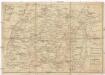
Reise-Karte von Schwaben mit angezeigten Chausseen und Strassen
1 : 800000 Švábsko (Německo) Amman, Ignaz Ambros von Staedelen, M. L. im Verlag der Stettinischen Buchhandlung
Circuli Sveviae
1 : 477000 Švábsko (Německo) Hase, Johann Matthias Homan[n]ianorum Heredum
Sveviae nova tabvla
1 : 880000 Švábsko (Německo) Blaeu, Willem Janszoon apud Guiljelmus Blaeuw
Nova Alemanniæ sive Sveviæ svperioris tabvla
1 Karte : Kupferdruck ; 36 x 47 cm Valck; Schenk apud G. Valk et P. Schenk
Alemannia Sive Suevia Superior [Karte], in: Novus Atlas, das ist, Weltbeschreibung, Bd. 1, S. 237.
1 Karte aus Atlas Blaeu, Joan Blaeu, Willem Janszoon
Königreich Bayern
Grosser Hand-Atlas über alle Theile der Erde in 170 Karten Meyer, J. Verlag des Bibliographischen Instituts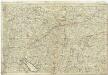
Le cours du Danube, depuis sa source jusques a Straubing
1 : 490000 Bavorsko (Německo) Jaillot, Alexis-Hubert
Nova Alemanniae Sive Sueviae Superioris Tabula. [Karte], in: Gerardi Mercatoris et I. Hondii Newer Atlas, oder, Grosses Weltbuch, Bd. 1, S. 241.
1 Karte aus Atlas Mercator, Gerhard und Hondius, Jodocus Jansson, Jan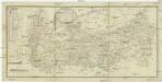
Commercial Charte
1 : 290000 Horní Rakousko (Rakousko) Eberle Walz
Partie meridionale de la Souabe
1 Karte : Kupferdruck ; 46 x 65 cm L'Isle; Ottens; Ottens chez R. et I. Ottens geogr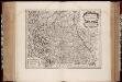
Alemannia sive Svevia svperior / a Christophoro Hurtero
1 : 500000 Annotatie: Origineel is Blad 120 in atlas factice; Annotatie geografische gegevens: Schaalstokken op kaart: Milliaria Alemanica quorum 12 um gradui respondent, en: Milliaria Germanica communia; West boven; Legenda linksonder: Expositio notarum Johann Christoph Hurter; Willem Jansz Blaeu 1571-1638 [Amsterdami] : [apud Guiljelmum Blaeu]
Alemannia sive Svevia Svperior
1 : 480000 Mollova mapová sbírka Hurter, Johann Christoph Blaeu, Joan I.
Nova Alemanniae sive Svevia Svperioris Tabvla
1 : 490000 Mollova mapová sbírka Hurter, Johann Christoph Janssonius, Johannes I
Deß Hayligen Römischen Reichs Schwebischen Kraysssampt seinen Vmb unnd Inligenden lannd vnnd Herrschafften
1 : 790000 Mollova mapová sbírka Mannasser, Daniel Mittnacht, Moritz
Alemannia Sive Suevia Superior [Karte], in: Le théâtre du monde, ou, Nouvel atlas contenant les chartes et descriptions de tous les païs de la terre, Bd. 1, S. 266.
1 Karte aus Atlas Blaeu, Willem Janszoon und Blaeu, Joan Blaeu, Willem Janszoon
Alemaniae sive Sveviae Svperioris Chorographia nova
1 : 310000 Mollova mapová sbírka Hurter, Johann Christoph Custos, Raphael
Nova Alemanniae Sive Sueviae Superioris Tabula. [Karte], in: Novus atlas absolutissimus, Bd. 2, S. 217.
1 Karte aus Atlas Janssonius Offizin
Alemannia Sive Suevia Superior [Karte], in: Theatrum orbis terrarum, sive, Atlas novus, Bd. 1, S. 280.
1 Karte aus Atlas Blaeu, Joan Blaeu, Willem Janszoon
Cercle de Souabe, dans lequel sont distingués les principaux etats, et les enclaves de la maison d'Autriche
1 Karte : Kupferdruck ; 46 x 50 cm Robert de Vaugondy; Remondini; Santini chez Mr. Remondini
Cercle de Souabe dans lequel sont distingués les principaux etats, et les enclaves de la maison d'Autriche
1 Karte : Kupferdruck ; 47 x 51 cm Robert de Vaugondy G. et D. Robert de Vaugondy
Alemannia sive Suevia Superior
Hurter, Christoph
Nova Alemanniae sive Sveviae Svperioris Tabvla
Hondius, Henricus


