Maps of Augsburg (district)
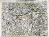
Carte topographique d'Allemagne contenant une partie de Baviere les principautés de Wurtemberg, d'Oettingen
1 Karte : Kupferdruck ; 45 x 63 cm Jaeger se vend chez l'auteur
Theatrum des Krieges in der Marggrafschaft Burgau
Mollova mapová sbírka Stridbeck, Johann Stridbeck, Johann II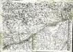
Geographica provinciarum Sueviae descriptio, 4
4 Blätter : Johann Georg Bodenehr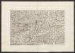
Militair Karte von Süd-Deutschland in 20 Sectionen
1 : 400000 10. Section Coulon, Alois von A. von Coulon
Suevia Universa :
1 : 170000 Mollova mapová sbírka Michal, Jacques de Seutter, Matthäus Seutter, Matthäus
Suevia universa IX. tabulis delineata, 3
1 Blatt : s.n.
München - Augsburg - Ulm

Umgegend von Ulm
1 : 200000 Kartographischen Abtheilung konigl Preuss
Neueste Karte von der Markgrafschaft Burgau zu den oesterreichischen Vorlanden in Schwaben gehörig
1 Karte : Kupferdruck ; 54 x 47 cm Probst; Sprengler Johann Michael Probst
Nieuwe Kaart, van t'Land Donawert, en Hochstett &c.
1 : 200000 Mollova mapová sbírka Visscher, Nicolaes Jansz. Visscher, Nicolaus II.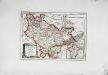
Die freye Reichsstadt Ulm mit ihrem Gebiete
1 Karte : Kupferdruck ; 19 x 27 cm Reilly F. J. J. von Reilly
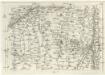
180. Angsburg, uit: Topographische Uebersichtskarte des Deutschen Reiches / herausgegeben v. d. Kartogr. Abt. d. Königl. Preuß. Landesaufnahme
1 : 200000 titelvariant: Topogr. Übersichtskarte des Deutschen Reiches; Annotatie: Titel boven bladen ook: Topogr. Übersichtskarte des Deutschen Reiches; Annotatie geografische gegevens: Op elk blad twee maatstokken: 10 Kilometer = 5,5 cm; 1 geogr. Meile = 3,6 cm; Legenda onder op elk blad Königlich Preußische Landesaufnahme. Kartographische Abtheilung [S.l : Königlich Preußische Landesaufnahme, Kartographische Abtheilung]
172. Nördlingen, uit: Topographische Uebersichtskarte des Deutschen Reiches / herausgegeben v. d. Kartogr. Abt. d. Königl. Preuß. Landesaufnahme
1 : 200000 titelvariant: Topogr. Übersichtskarte des Deutschen Reiches; Annotatie: Titel boven bladen ook: Topogr. Übersichtskarte des Deutschen Reiches; Annotatie geografische gegevens: Op elk blad twee maatstokken: 10 Kilometer = 5,5 cm; 1 geogr. Meile = 3,6 cm; Legenda onder op elk blad Königlich Preußische Landesaufnahme. Kartographische Abtheilung [S.l : Königlich Preußische Landesaufnahme, Kartographische Abtheilung]
Novissima delineatio Marchionatus Burgoviae
1 : 150000 Mollova mapová sbírka Michal, Jacques de Seutter, Matthäus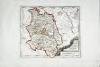
Die Grafschaft Oetingen
1 Karte : Kupferdruck ; 23 x 27 cm Reilly F. J. J. von Reilly
Augsburg
1 : 200000 Herder, Benjamin
Pars IV. monstrat mediam partem ducat: Bavariæ, urbem jmp: Augustam Vindelicorum, cum parte ducat Neoburg, et episc. Frising
1 Karte : 54 x 52 cm Heinrich Ludwig Broenner
Nova et accurata territorii Vlmensis cum dominio Wainensi descriptio
1 Karte : Kupferdruck ; 47 x 56 cm Lauterbach; Homann Johann Baptist Homann
Nova et accurata territorii Vlmensis cum dominio Wainensi descriptio
1 Karte : Kupferdruck ; 47 x 56 cm Lauterbach; Homann Johann Baptist Homann
Monstrat mediam Partem Ducat: Bavariæ, Urbem Jmp: Augustam Vindelicorum, cum Parte Ducat Neoburg, et Episc. Frising
1 : 150000 Mollova mapová sbírka Buna, Wilhelm C. Broenner, Heinrich Ludwig
Augsburg mit der gegend auf 2 Stunden.
1 : 150000 Mollova mapová sbírka Bodenehr, Gabriel Bodenehr, Gabriel
Nova et accurata Territorii Vlmensis cum Dominio Wainensi Descriptio
1 : 100000 Mollova mapová sbírka Lauterbach, Johann Christoph Homann, Johann Baptista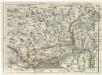
Geographica Provinciarum Sveviae Descriptio =
Mollova mapová sbírka Hurter, Johann Christoph Bodenehr, Gabriel
Geographica Provinciarum Sveviae Descriptio =
Mollova mapová sbírka Hurter, Johann Christoph Bodenehr, Johann Georg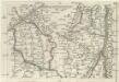
Geographica Provinciarum Sveviae Descriptio =
Mollova mapová sbírka Hurter, Johann Christoph Bodenehr, Gabriel
Geographica Provinciarum Sveviae Descriptio =
Mollova mapová sbírka Hurter, Johann Christoph Bodenehr, Johann Georg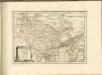

Nova et accurata territorii Vlmensis cum dominio Wainensi descriptio
1 : 100000 Bádensko-Württembersko (Německo) Lauterbach, Johann Christoph Homann, Johann Baptist Ioh. Baptista Homann


