Maps of Swabia

Nova Alemanniæ sive Sveviæ svperioris tabvla
1 Karte : Kupferdruck ; 36 x 47 cm Valck; Schenk apud G. Valk et P. Schenk
Alemannia Sive Suevia Superior [Karte], in: Novus Atlas, das ist, Weltbeschreibung, Bd. 1, S. 237.
1 Karte aus Atlas Blaeu, Joan Blaeu, Willem Janszoon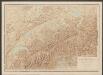
Nova Alemanniae Sive Sueviae Superioris Tabula. [Karte], in: Gerardi Mercatoris et I. Hondii Newer Atlas, oder, Grosses Weltbuch, Bd. 1, S. 241.
1 Karte aus Atlas Mercator, Gerhard und Hondius, Jodocus Jansson, Jan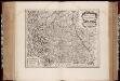
Alemannia sive Svevia svperior / a Christophoro Hurtero
1 : 500000 Annotatie: Origineel is Blad 120 in atlas factice; Annotatie geografische gegevens: Schaalstokken op kaart: Milliaria Alemanica quorum 12 um gradui respondent, en: Milliaria Germanica communia; West boven; Legenda linksonder: Expositio notarum Johann Christoph Hurter; Willem Jansz Blaeu 1571-1638 [Amsterdami] : [apud Guiljelmum Blaeu]
Alemannia Sive Suevia Superior [Karte], in: Le théâtre du monde, ou, Nouvel atlas contenant les chartes et descriptions de tous les païs de la terre, Bd. 1, S. 266.
1 Karte aus Atlas Blaeu, Willem Janszoon und Blaeu, Joan Blaeu, Willem Janszoon
Nova Alemanniae Sive Sueviae Superioris Tabula. [Karte], in: Novus atlas absolutissimus, Bd. 2, S. 217.
1 Karte aus Atlas Janssonius Offizin
Alemannia Sive Suevia Superior [Karte], in: Theatrum orbis terrarum, sive, Atlas novus, Bd. 1, S. 280.
1 Karte aus Atlas Blaeu, Joan Blaeu, Willem Janszoon
Alemannia sive Suevia Superior
Hurter, Christoph
Nova Alemanniae sive Sveviae Svperioris Tabvla
Hondius, Henricus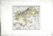
Die Markgrafschaft Burgau mit den Grafschaften Kirchberg und Weissenhorn
1 Karte : Kupferdruck ; 21 x 23 cm Reilly F. J. J. von Reilly
ALEMANNIA | SIVE | SVEVIA SVPERIOR
A. Christophoro Hurtero. [Amsterdam : Joan Blaeu]
Sect. 26: Augsburg, uit: Geologische Karte des Deutschen Reichs in 27 Blaettern / [von] Richard Lepsius ; Red. von C. Vogel
1 : 500000 Annotatie: Blad 18 ontbreekt; Een aantal bladen op linnen; Een aantal bladen gereviseerd 1913-1914; Annotatie geografische gegevens: Met schaalstokken o.a. in kilometers; Legenda Carl Vogel 1828-1897 Gotha : Justus Perthes
Alemannia sive Svevia Svperior
1 : 480000 Mollova mapová sbírka Hurter, Johann Christoph Blaeu, Joan I.
Nova Alemanniae sive Svevia Svperioris Tabvla
1 : 490000 Mollova mapová sbírka Hurter, Johann Christoph Janssonius, Johannes I
Alemaniae sive Sveviae Svperioris Chorographia nova
1 : 310000 Mollova mapová sbírka Hurter, Johann Christoph Custos, Raphael
Partie meridionale de la Souabe
1 Karte : Kupferdruck ; 46 x 65 cm L'Isle; Ottens; Ottens chez R. et I. Ottens geogr

Deß Hayligen Römischen Reichs Schwebischen Kraysssampt seinen Vmb unnd Inligenden lannd vnnd Herrschafften
1 : 790000 Mollova mapová sbírka Mannasser, Daniel Mittnacht, Moritz
Per Inclyti Circuli Suevici Supremorum Ordinum :
1 : 160000 Mollova mapová sbírka Pfeffel, Johann Andreas Homann, Johann Baptista - dědici
Per Inclyti Circuli Suevici Supremorum Ordinum :
1 : 160000 Mollova mapová sbírka Pfeffel, Johann Andreas Pfeffel, Johann Andreas I.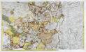
Geographica Sueviæ universæ descriptio, 4
2 Blätter : Homännische Erben
[Exactissima Helvetiae, Rhaetiae, Valesiae ... tabula]
1 : 850000 9 Karten [Kopie von Adrian Braakman] [chez Pierre Schenk et Adrian Braakman], [Amsterdam]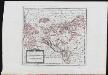
Die in und um Schwaben gelegenen Östreichischen Antheile in der ämtlichen Sprache Vorderöstreich : Nro. 58
Reilly, Franz Johann Joseph von
Partie septentrionale de la Souabe
1 : 280000 par Guillaume De L'Isle A Amsterdam : chez J. Covens et C. Mortier
Pars Sueviæ australior
1 Karte : Kupferdruck ; 46 x 61 cm L'Isle; Lotter apud Tobiam Conradum Lotter calcogr
Partie meridionale de la Souabe
1 Karte : Kupferdruck ; 46 x 62 cm L'Isle; Renard chez l'auteur sur le quai de l'Horloge, chez L. Renard libraire prez de la bourse
Circulus Suevicus in quo ducatus Wirtenbergensis cum reliquis statibus et provinciis curate designatus propomtur
1 : 640000 Württembersko (Německo) Lotter, Tobias Conrad studio et caelo Tobiae Conradi Lotter
Cercle de Souabe, dans lequel sont distingués les principaux etats, et les enclaves de la maison d'Autriche
1 Karte : Kupferdruck ; 46 x 50 cm Robert de Vaugondy; Remondini; Santini chez Mr. Remondini
Cercle de Souabe dans lequel sont distingués les principaux etats, et les enclaves de la maison d'Autriche
1 Karte : Kupferdruck ; 47 x 51 cm Robert de Vaugondy G. et D. Robert de Vaugondy


