Maps of Balkan Pen.

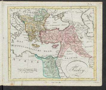
Türkey
Allgemeiner Atlas [Walch, Johannes] im Verlag bei Johannes Walch
Das osmannische Reich, XVIIten Jahrhundert.
1 : 9200000 Spruner von Merz, Karl
Principal Countries of the Ancient World.
1 : 7100000 Hughes, William
Osmanisches Reich und seine Schutzstaaten im XVIIten Jahrhundert
1 : 9000000 Osmanisches Reich Protektorat
Das türkische Reich
Afrika severní
Carte patriculiére des pais ou les apôtres ont preché l'euangile, des lieux les plus renommez de leurs voyages, et de la route de St. Paul a Rome
Středozemní moře-oblast Luchtenburg, I. van Mortier, Pieter Pierre Mortier
Tableau historique de l'Empire d'Oriens.
1 : 18500000 Duval, Henri
[Des Mittelländischen Meeres öestliches Blatt. Zur Uebersicht des Türkischen Reichs und als Pecial-Karte der Asiatischen u. Afrikanischen Türkey]
Stieler's Hand-Atlas Stieler, Adolf bei Justus Perthes
Regna succesorum Alexandri Magni
1 : 9400000 Asie jihozápadní Spruner, Karl von Alt, Wilhelm Justus Perthes
[Das Mittelländische Meer und Nord-Afrika, Östliches Blatt]
Hand-Atlas über alle Theile der Erde und über das Weltgebäude Stieler, Adolf Justus Perthes
Tableau l'historie de l'Empire des Califes et de l'Empire de Turquie.
1 : 20000000 Duval, Henri
[Das Mittelländische Meer und Nord-Afrika]
Handatlas über alle Theile der Erde und über das Weltgebäude Stieler, Adolf Justus Perthes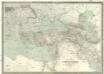
Carte générale de l'Empire Ottoman en Europe et en Asie
1 : 3000000 osmanská říše Kiepert, Heinrich D. Reimer
A map of the eastern part of the Roman empire
1 Karte : Kupferdruck ; 39 x 42 cm s.n.
Osmanisches Reichs.
1 : 11800000 Radefeld, Carl Christian Franz, 1788-1874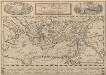
Peregrinationis Divi Pauli Typus Corographicus. [...] [Karte], in: Theatrum orbis terrarum, S. 441.
1 Karte aus Atlas Ortelius, Abraham Vrients, Jan Baptista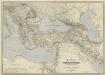
General-Karte des Türkischen Reiches in Europa und Asien nebst Ungarn, Südrussland, den kaukasischen Ländern und West-Persien
1 : 3000000 entworfen und bearb. von Heinrich Kiepert Stich und Druck der lithographischen Anstalt von L. Kraatz Berlin : Reimer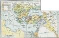
Osmanisches Reich bis 1683
1 : 18000000 Osmanisches Reich Expansion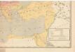
Evropa raného středověku: do konce VI. století po Kr.
Kašpar, Jan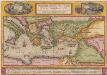
Peregrinationis Divi Pauli Typus Corographicus [...] [Karte], in: Theatrum orbis terrarum, S. 442.
1 Karte aus Atlas Ortelius, Abraham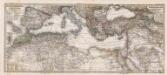
Composite: Mittellandische Meer, Nord-Afrika.
1 : 7500000 Petermann, A.
Übersichts - Karte des Türkischen Reichs in Europa und Asien

Turquia asiàtica / Ramon Alabern lo grabó
1 mapa. Datat al 1850 aproximadament. Alaber, Ramon
[Afrika, Blatt 2]
Adolf Stieler's Handatlas über alle Theile der Erde und über das Weltgebäude Stieler, Adolf Justus Perthes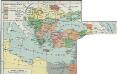
I. Osmanisches Reich bis 1683
1 : 28000000 Osmanisches Reich Expansion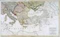
Carte generale de toute l'Europe, 3
2 Blätter : 56 x 90 cm J.M. Will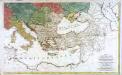
Carte générale de toute l'Europe, 2
2 Blätter : 57 x 93 cm T.C. Lotter
Imperium Turcicum
Turecko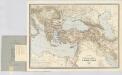
Carte générale des provinces européennes et asiatiques de l'Empire Ottoman, uit: Carte générale des provinces européennes et asiatiques de l'Empire Ottoman (sans l'Arabie) / dressée par Henri Kiepert ; le trait et la lettre gravés chez L. Kraatz ; le figure du terrain gravé par J. Sulzer
1 : 3000000 Annotatie: Op omslag ook: Deuxième édition entièrement corrigée et augmentée d'un index alphabétique (quatrième édition de la 'Carte générale de l'Empire Ottoman en Europe et en Asie'); Met: Index alfabétique. - 40 p; Annotatie geografische gegevens: Legenda Johann Samuel Heinrich Kiepert 1818-1899; Leopold Kraatz; J. Sulzer Berlin : Dietrich Reimer (Hoefer u. Vohsen) / ([S.l. : L. Kraatz])