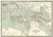
Maps of Balkan Pen.

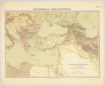
Zuid-oostelijk oorlogsterrein
1 : 6000000 Annotatie geografische gegevens: Op de kaart zijn vestingen en forten aangegeven 's-Gravenhage : Smulders
Uebersichts-Karte des Russisch - Türkischen Kriegsschauplatzes
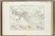
Carte générale de l'Empire Ottoman en Europe et en Asie
1 : 3000000 osmanská říše Kiepert, Heinrich D. Reimer
General-Karte des Türkischen Reiches in Europa und Asien nebst Ungarn, Südrussland, den kaukasischen Ländern und West-Persien
1 : 3000000 entworfen und bearb. von Heinrich Kiepert Stich und Druck der lithographischen Anstalt von L. Kraatz Berlin : Reimer
Übersichts - Karte des Türkischen Reichs in Europa und Asien
Nouveau Testament, regions, lieux.
1 : 10200000 Bonne, Rigobert, 1727-1794
Impero di Alessandro.
1 : 11200000 Picquet, C.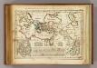
Regions, lieux dans le Nouveau Testament.
1 : 18000000 Delamarche, Charles Francois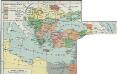
I. Osmanisches Reich bis 1683
1 : 28000000 Osmanisches Reich Expansion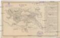
Das türkische Reich
Afrika severní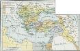
Osmanisches Reich bis 1683
1 : 18000000 Osmanisches Reich Expansion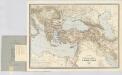
Carte générale des provinces européennes et asiatiques de l'Empire Ottoman, uit: Carte générale des provinces européennes et asiatiques de l'Empire Ottoman (sans l'Arabie) / dressée par Henri Kiepert ; le trait et la lettre gravés chez L. Kraatz ; le figure du terrain gravé par J. Sulzer
1 : 3000000 Annotatie: Op omslag ook: Deuxième édition entièrement corrigée et augmentée d'un index alphabétique (quatrième édition de la 'Carte générale de l'Empire Ottoman en Europe et en Asie'); Met: Index alfabétique. - 40 p; Annotatie geografische gegevens: Legenda Johann Samuel Heinrich Kiepert 1818-1899; Leopold Kraatz; J. Sulzer Berlin : Dietrich Reimer (Hoefer u. Vohsen) / ([S.l. : L. Kraatz])
Carte generale de toute l'Europe, 3
2 Blätter : 56 x 90 cm J.M. Will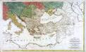
Carte générale de toute l'Europe, 2
2 Blätter : 57 x 93 cm T.C. Lotter
Turcici Imperii descriptio
1 : 12000000 Ortelius, Abraham, 1527-1598 A. Ortelius
Osmanisches Reichs.
1 : 11800000 Radefeld, Carl Christian Franz, 1788-1874
L’Europe Nord-Orientale au 5e siècle avant notre ère, d’après Hérodote
Europa
A map of the eastern part of the Roman empire
1 Karte : Kupferdruck ; 39 x 42 cm s.n.

Turcia Asiatica : exhibens Natoliam modernam, in suos beglirbegatus divisam, itemque reliquos beglirbegatus, sive gubernationes et Prœfecturas generales, in regionibus Georgiæ, Armeniæ, Mespotamiæ, Syriæ et Arabiæ sitos, una cum Mari Nigro, Mari Azowiensi, Mari di Marmora, et Mari Ægeo, atque adiacentibus Insulis : C. P. S. C. M. = Carte de la Turquie asiatique contenant la Natolie moderne divisée en les beglerbeys &
1 : 4800000 Homann Erben (Firm) Homannianorum Heredum
Der orientalische Kriegsschauplatz aus der Vogelschau

Osmanisches Reich und seine Schutzstaaten im XVIIten Jahrhundert
1 : 9000000 Osmanisches Reich Protektorat
Magni Turcarum dominatoris imperium per Europam, Asiam, et Africam, se extendens regiones tam proprias, quam tributarias et clientelares ut et omnes Beglerbegatus sive praefecturas generales
1 : 11000000 oculis sistens accuratissima cura delineatum per Tob. Conr. Lotter Abraham Drentwet Junior del. [Augsburg] : Tob. Conr. Lotter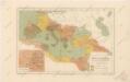
Říše římská ve své největší rozsáhlosti

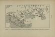
Balkánské státy a Turecko
1 : 3000000 Bospor (Turecko : průliv) Paulík, Ant. Klus, František Ústřední učitelské nakladatelství a knihkupectví
Tvrcicvm imperivm
1 : 11560000 Turecko Janssonius, Johannes sumpt. Ioannis Ianßonii