Maps of Balkan Pen.

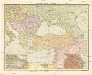
Balkánské státy a Turecko
1 : 3000000 Bospor (Turecko : průliv) Paulík, Ant. Klus, František Ústřední učitelské nakladatelství a knihkupectví
Südeuropa
1 : 2500000 Blízký východ Gea Verlag
Nouveau Testament, regions, lieux.
1 : 10200000 Bonne, Rigobert, 1727-1794
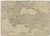
Übersichts - Karte des Türkischen Reichs in Europa und Asien
Carte generale de toute l'Europe, 3
2 Blätter : 56 x 90 cm J.M. Will
Carte générale de toute l'Europe, 2
2 Blätter : 57 x 93 cm T.C. Lotter
Uebersichts-Karte des Russisch - Türkischen Kriegsschauplatzes

Das Osmanische Reich nach seiner grössten Ausdehnung im XVIIten Jahrhundert
1 : 12000000 Osmanisches Reich
La mer Mediterranée vers l'orient
1 Karte : Kupferdruck ; 38 x 49 cm Duval P. Duval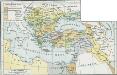
Osmanisches Reich bis 1683
1 : 18000000 Osmanisches Reich Expansion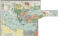
I. Osmanisches Reich bis 1683
1 : 28000000 Osmanisches Reich Expansion
Zuid-oostelijk oorlogsterrein
1 : 6000000 Annotatie geografische gegevens: Op de kaart zijn vestingen en forten aangegeven 's-Gravenhage : Smulders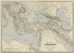
General-Karte des Türkischen Reiches in Europa und Asien nebst Ungarn, Südrussland, den kaukasischen Ländern und West-Persien
1 : 3000000 entworfen und bearb. von Heinrich Kiepert Stich und Druck der lithographischen Anstalt von L. Kraatz Berlin : Reimer
Tableau historique de l'Empire d'Oriens.
1 : 18500000 Duval, Henri
[Ethnographische Karte von Europa]
Zweiter Band, enthaltend in vier Abtheilungen die Vertheilung der Organismen: 5. Pflanzen-Geographie, 6. Thier-Geographie, 7. Anthropographie, 8. Ethnographie Humboldt, Alexander von Verlag von Justus Perthes
Osmanisches Reichs.
1 : 11800000 Radefeld, Carl Christian Franz, 1788-1874
Carte générale des provinces européennes et asiatiques de l'Empire Ottoman, uit: Carte générale des provinces européennes et asiatiques de l'Empire Ottoman (sans l'Arabie) / dressée par Henri Kiepert ; le trait et la lettre gravés chez L. Kraatz ; le figure du terrain gravé par J. Sulzer
1 : 3000000 Annotatie: Op omslag ook: Deuxième édition entièrement corrigée et augmentée d'un index alphabétique (quatrième édition de la 'Carte générale de l'Empire Ottoman en Europe et en Asie'); Met: Index alfabétique. - 40 p; Annotatie geografische gegevens: Legenda Johann Samuel Heinrich Kiepert 1818-1899; Leopold Kraatz; J. Sulzer Berlin : Dietrich Reimer (Hoefer u. Vohsen) / ([S.l. : L. Kraatz])
Carte générale de l'Empire Ottoman en Europe et en Asie
1 : 3000000 osmanská říše Kiepert, Heinrich D. Reimer
L’Europe Nord-Orientale au 5e siècle avant notre ère, d’après Hérodote
Europa
Das Osmanische Reich nach seiner größten Ausdehnung im XVII. Jahrhundert.
osmanská říše Benecke Bormann, E. F. Tempsky
Východní Středomoří
Kuchař, Karel
A map of the eastern part of the Roman empire
1 Karte : Kupferdruck ; 39 x 42 cm s.n.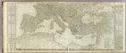
(Europe divided into its empires, kingdoms, states, republics, &c. Southern States)
1 : 4800000 Kitchin, Thomas
Střední Evropa a Přední Asie za časů III. války křížové
Europaeische und asiatische Türkey
1 : 7100000 Blízký východ Mollo, Tranquillo T. Mollo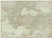
Europaeische und asiatische Türkey
1 : 7100000 Evropa jihovýchodní Mollo, Tranquillo Tranquillo Mollo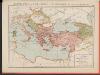
L'Empire Grec à la mort de Basile le Bulgarochtone et sous ses Héritiers
Byzantinisches Reich Basileios II.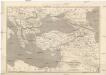
Map of the Ottoman Empire, Kingdom of Greece, and the russian provinces on the Black Sea
1 : 5900000 balkánské země Dower, John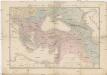
Carte du théatre de la guerre
Asie jihozápadní Andriveau-Goujon, Eugene Monrocq