Maps of Balkan Pen.
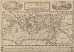
Peregrinationis Divi Pauli Typus Corographicus. [...] [Karte], in: Theatrum orbis terrarum, S. 441.
1 Karte aus Atlas Ortelius, Abraham Vrients, Jan Baptista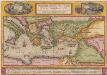
Peregrinationis Divi Pauli Typus Corographicus [...] [Karte], in: Theatrum orbis terrarum, S. 442.
1 Karte aus Atlas Ortelius, Abraham
Das osmannische Reich, XVIIten Jahrhundert.
1 : 9200000 Spruner von Merz, Karl
A map of the eastern part of the Roman empire
1 Karte : Kupferdruck ; 39 x 42 cm s.n.
Osmanisches Reichs.
1 : 11800000 Radefeld, Carl Christian Franz, 1788-1874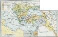
Osmanisches Reich bis 1683
1 : 18000000 Osmanisches Reich Expansion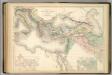
Principal Countries of the Ancient World.
1 : 7100000 Hughes, William
Carte patriculiére des pais ou les apôtres ont preché l'euangile, des lieux les plus renommez de leurs voyages, et de la route de St. Paul a Rome
Středozemní moře-oblast Luchtenburg, I. van Mortier, Pieter Pierre Mortier
Tableau historique de l'Empire d'Oriens.
1 : 18500000 Duval, Henri
Orbis Romani, orientalis.
1 : 11500000 Anville, Jean Baptiste Bourguignon d, 1697-1782; M'Dermut, Robert
Das türkische Reich
Afrika severní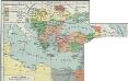
I. Osmanisches Reich bis 1683
1 : 28000000 Osmanisches Reich Expansion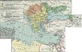
II. Rückgang des Osmanischen Reichs (Orientalische Frage) seit 1683
1 : 28000000 Osmanisches Reich
Türkey
Allgemeiner Atlas [Walch, Johannes] im Verlag bei Johannes Walch
De landen van 't Romeinsche gebied in welke de Christen kerk, kort na Christus hemelvaard, door den dienst der apostelen is uitgebreid : tot verklaringe van de Handelingen der Apostelen
1 : 6500000 afgebeeld door W.A. Bachiene J. van Jagen mapp. sculpsit, et figur. apposit sculpturam curavit ; S. Fokke fecit. Uitgegeven te Gorinchem : by Nicolaas Goetzee
Orbis Homeri. 900? Ante Chr.
Mittelmeerraum Homerus
[Des Mittelländischen Meeres öestliches Blatt. Zur Uebersicht des Türkischen Reichs und als Pecial-Karte der Asiatischen u. Afrikanischen Türkey]
Stieler's Hand-Atlas Stieler, Adolf bei Justus Perthes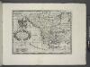
A new map of Turky in Europe and parts adjoyning shewing their principal divisions and chief cities, towns, rivers, mountains &c.
from A new sett of maps both of antient and present geography : wherein not only the latitude and longitude of many places are corrected according to the latest observations, but also the most remarkable differences of antient and present geography may be quickly discern'd by a bare inspection or comparing of correspondent maps, which seems to be the most natural and easy method to lead young students (for whose use the work is principally intended) unto a competent knowledge of the geographical science : together with a geographical treatise particularly adapted to the use and design of these maps / by Edward Wells, M.A. and student of Christ-Church, Oxon.
Karte der griechischen Welt
Evropa jižní F. Tempsky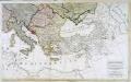
Carte generale de toute l'Europe, 3
2 Blätter : 56 x 90 cm J.M. Will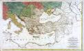
Carte générale de toute l'Europe, 2
2 Blätter : 57 x 93 cm T.C. Lotter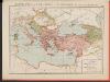
L'Empire Grec à la mort de Basile le Bulgarochtone et sous ses Héritiers
Byzantinisches Reich Basileios II.
Osmanisches Reich und seine Schutzstaaten im XVIIten Jahrhundert
1 : 9000000 Osmanisches Reich Protektorat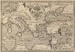
Argonautica. [Karte] [Europa.], [Thessalia und Umgebung], [Hellespontus, Phryxeum aequor, et Athamantidis fluenta.] [3 Nebenkarten], in: Theatrum orbis terrarum, S. 538.
1 Karte aus Atlas Ortelius, Abraham Vrients, Jan Baptista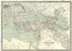
Carte générale de l'Empire Ottoman en Europe et en Asie
1 : 3000000 osmanská říše Kiepert, Heinrich D. Reimer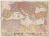
Mittelmeerländer
1 : 4000000 Afrika severní Georg Westermann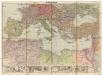
Mittelmeerländer
1 : 4000000 Afrika severní Georg Westermann
Orbis Romani Pars Orientalis.
1 : 10137600 Lucas, Fielding Jr.
Orbis Romani, pars orientalis.
1 : 4300000 Anville, Jean Baptiste Bourguignon d, 1697-1782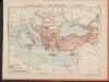
![Peregrinationis Divi Pauli Typus Corographicus. [...] [Karte], in: Theatrum orbis terrarum, S. 441.](https://images-2.georeferencer.com/images/iiif/966982209993/full/,300/0/native.jpg)

