Maps of Turkey
Evropa raného středověku: do konce VI. století po Kr.
Kašpar, Jan
Carte patriculiére des pais ou les apôtres ont preché l'euangile, des lieux les plus renommez de leurs voyages, et de la route de St. Paul a Rome
Středozemní moře-oblast Luchtenburg, I. van Mortier, Pieter Pierre Mortier
[Das Mittelländische Meer und Nord-Afrika, Östliches Blatt]
Hand-Atlas über alle Theile der Erde und über das Weltgebäude Stieler, Adolf Justus Perthes
Tableau l'historie de l'Empire des Califes et de l'Empire de Turquie.
1 : 20000000 Duval, Henri
[Das Mittelländische Meer und Nord-Afrika]
Handatlas über alle Theile der Erde und über das Weltgebäude Stieler, Adolf Justus Perthes
[Afrika, Blatt 2]
Adolf Stieler's Handatlas über alle Theile der Erde und über das Weltgebäude Stieler, Adolf Justus Perthes
Tableau historique de l'Empire d'Oriens.
1 : 18500000 Duval, Henri
Osmanisches Reich und seine Schutzstaaten im XVIIten Jahrhundert
1 : 9000000 Osmanisches Reich Protektorat
Türkey
Allgemeiner Atlas [Walch, Johannes] im Verlag bei Johannes Walch
Regna succesorum Alexandri Magni
1 : 9400000 Asie jihozápadní Spruner, Karl von Alt, Wilhelm Justus Perthes
[Des Mittelländischen Meeres öestliches Blatt. Zur Uebersicht des Türkischen Reichs und als Pecial-Karte der Asiatischen u. Afrikanischen Türkey]
Stieler's Hand-Atlas Stieler, Adolf bei Justus Perthes
Das osmannische Reich, XVIIten Jahrhundert.
1 : 9200000 Spruner von Merz, Karl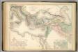
Principal Countries of the Ancient World.
1 : 7100000 Hughes, William
Turquia asiàtica / Ramon Alabern lo grabó
1 mapa. Datat al 1850 aproximadament. Alaber, Ramon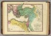
Patriarchati Orientales. (1826)
1 : 19000000 Tanner, Henry S.
Orbis Romani, orientalis.
1 : 11500000 Anville, Jean Baptiste Bourguignon d, 1697-1782; M'Dermut, Robert
Das türkische Reich
Afrika severní
Orbis Romani Pars Orientalis.
1 : 10137600 Lucas, Fielding Jr.
Orbis Romani, pars orientalis.
1 : 4300000 Anville, Jean Baptiste Bourguignon d, 1697-1782
Imperium Turcicum
Turecko
Das Osmanische Reich nebst seinen Schutzstaaten nach seiner grössten Ausdehnung 1682
Osmanisches Reich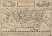
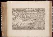
Peregrinationis Divi Pauli Typus Corographicus. [...] [Karte], in: Theatrum orbis terrarum, S. 441.
1 Karte aus Atlas Ortelius, Abraham Vrients, Jan Baptista
Říše turecká
1 : 5000000 Asie jihozápadní V. Neubert
Di-gyiu Du, Ng Da-tsiu Di-du[地舆图、五大洲地图]
Di-gyiu Du, Ng Da-tsiu Di-du[地舆图、五大洲地图] 1853年,Martin, W. A. P. (William Alexander Parsons) 美国长老会传教士丁韪良用罗马拼音标注宁波方言编写的世界地理著作,对地球和各大洲进行介绍。内有东西半球图、亚洲图、欧洲图、非洲图、北美洲图、南美洲图、地中海附近图、清内地十八省图、浙江省图、宁波附近图等。 10图,墨刻本,罗马拼音标注宁波方言,图幅不一,约39 x 49.5 cm Harvard-Yenching | Rare Book | TA 2370 92,Hollis Number:008156153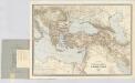
Carte générale des provinces européennes et asiatiques de l'Empire Ottoman, uit: Carte générale des provinces européennes et asiatiques de l'Empire Ottoman (sans l'Arabie) / dressée par Henri Kiepert ; le trait et la lettre gravés chez L. Kraatz ; le figure du terrain gravé par J. Sulzer
1 : 3000000 Annotatie: Op omslag ook: Deuxième édition entièrement corrigée et augmentée d'un index alphabétique (quatrième édition de la 'Carte générale de l'Empire Ottoman en Europe et en Asie'); Met: Index alfabétique. - 40 p; Annotatie geografische gegevens: Legenda Johann Samuel Heinrich Kiepert 1818-1899; Leopold Kraatz; J. Sulzer Berlin : Dietrich Reimer (Hoefer u. Vohsen) / ([S.l. : L. Kraatz])
A new map shewing all the severall countries, cities, towns and other places mentioned in the New Testament [1 - in Greece Cyprus, Asia and parts adjoining; 2 - in Italy, Mesopotamia &c.; 3 - in the Holy Land and parts adjoining.]
from A new sett of maps both of antient and present geography : wherein not only the latitude and longitude of many places are corrected according to the latest observations, but also the most remarkable differences of antient and present geography may be quickly discern'd by a bare inspection or comparing of correspondent maps, which seems to be the most natural and easy method to lead young students (for whose use the work is principally intended) unto a competent knowledge of the geographical science : together with a geographical treatise particularly adapted to the use and design of these maps / by Edward Wells, M.A. and student of Christ-Church, Oxon.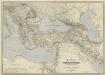
General-Karte des Türkischen Reiches in Europa und Asien nebst Ungarn, Südrussland, den kaukasischen Ländern und West-Persien
1 : 3000000 entworfen und bearb. von Heinrich Kiepert Stich und Druck der lithographischen Anstalt von L. Kraatz Berlin : Reimer
Das Oströmische Reich zur Zeit Karls des Gr.
Byzantinisches Reich
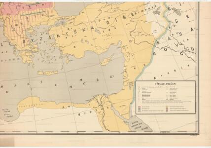
[Recto], uit: Midden-Oosten (Nabije-Oosten) / [aardrijksk. medew. G.J. de Vries]
1 : 13700000 Annotatie: Verso: namen van de landen van het Midden-oosten met aanduiding van de oppervlakte en het aantal inwoners,de hoofdsteden met vermelding van het het aantal inwoners, en informatie over het Suezkanaal; Annotatie geografische gegevens: Inzet: Suez Kanaal Gerben Johannes de Vries 1886-1968 Sneek : Tonnema