Maps of Metropolitan France

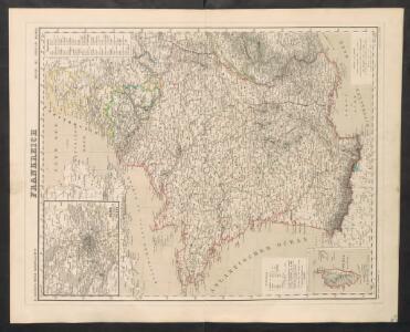
Frankreich
Neuer Handatlas über alle Theile der Erde Kiepert, Heinrich Verlag von Dietrich Reimer
Composite: France, Belgium, Holland.
1 : 1000000 John Bartholomew & Co.
Gallia Antiqua. (1826)
1 : 5200000 Tanner, Henry S.
France.
1 : 4550000 Darton, William
Neue Orientierungkarte [von] Frankreich u[nd] Mittelmeerlä[nder]
Francie
France in provinces.
1 : 3450000 Society for the Diffusion of Useful Knowledge (Great Britain)
Ancient France.
1 : 3500000 Society for the Diffusion of Useful Knowledge (Great Britain)
LA FRANCE en 1812
Francie Las Cases, Emmanuel-Auguste-Dieudonné Didot, Pierre Jules Didot Ainé
Carte Historique de la Region Francaise.
1 : 2550000 Jouvet et Cie.
Galliae Veteris Typus. [Karte], in: Theatrum orbis terrarum, S. 374.
1 Karte aus Atlas Ortelius, Abraham
France Administrative.
1 : 2550000 Jouvet et Cie.
France Forestiere.
1 : 2550000 Jouvet et Cie.
Frankreich
1 : 5000000 Francie Kocen, Blaž Eduard Hölzel
France Militaire.
1 : 2550000 Jouvet et Cie.
Francie, Belgie, Nizozemí, Lucembursko

Charte von Frankreich
1 : 2400000 Francie Streit, Friedrich Wilhelm Geograph. Instituts
Charte von Frankreich
1 : 2400000 Francie Streit, Friedrich Wilhelm Geograph. Instituts
Carte Geologique de la Region Francaise.
1 : 2550000 Jouvet et Cie.
Carte Physique de la Region Francaise.
1 : 2550000 Jouvet et Cie.
France.
1 : 3000000 Colton, G.W.
France Industrielle et Commerciale.
1 : 2550000 Jouvet et Cie.
Frankreich

La France.
1 : 1970000 Levasseur, Victor.
Gallia
1 : 4250000 Francie Plancius, Petrus Petrus Plancius
Gallia Antiqua.
1 : 2500000 Anville, Jean Baptiste Bourguignon d, 1697-1782
Frankreich nach der alten und neuen Eintheilung
1 Karte : Kupferdruck ; 28 x 24 cm Sotzmann; Jättnig s.n.
Le royaume de France
1 Karte : Kupferdruck ; 46 x 55 cm Seutter Matthäus Seutter
France.
1 : 3100000 Colton, G.W.