Maps of Metropolitan France

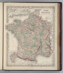
France.
1 : 3000000 Colton, G.W.
Carte Historique de la Region Francaise.
1 : 2550000 Jouvet et Cie.
France Forestiere.
1 : 2550000 Jouvet et Cie.
France Administrative.
1 : 2550000 Jouvet et Cie.
France Industrielle et Commerciale.
1 : 2550000 Jouvet et Cie.
France Militaire.
1 : 2550000 Jouvet et Cie.
Carte Physique de la Region Francaise.
1 : 2550000 Jouvet et Cie.
Carte Geologique de la Region Francaise.
1 : 2550000 Jouvet et Cie.
Carte particuliere des postes de France
1 Karte auf 2 Blättern : Kupferdruck ; 65 x 59 cm Jaillot; Sanson chez H. Iaillot
Frankreich

France.
1 : 3000000 Colton, G.W.
France.
1 : 1950000 Arrowsmith, John
France.
1 : 3100000 Colton, G.W.
France ... Holland And Belgium.
1 : 1330560 Johnson, A.J.
France.
1 : 3168000 Colton, G.W.
France.
1 : 3180000 Mitchell, Samuel Augustus
Carte de France
1 Karte : Kupferdruck ; 28 x 29 cm s.n.
Nouvelle topographie de la France
1 Karte : Kupferdruck ; 54 x 54 cm Hesseln; Delahaye s.n.
Regno di Francia
1 Karte : Kupferdruck ; 28 x 38 cm Zatta presso Antonio Zatta
Carte des routes de postes de l'Empire Français
1 : 2200000 Francie Pachoux, J. J. Tardieu, Pierre François
La France.
1 : 1970000 Levasseur, Victor.

Frankreich
1 : 1865000 Francie Weiland, Karl Ferdinand im Verlage des geographischen Instituts
Frankreich
1 : 1900000 Francie Weiland, Karl Ferdinand im Verlage des geographischen Instituts
Frankreich
1 : 1865000 Francie Weiland, Karl Ferdinand im Verlage des geographischen Instituts
Carte Particuliere Des Postes De France [Karte], in: Atlas nouveau, contenant toutes les parties du monde [...], Bd. 1, S. 147.
1 Karte aus Atlas Sanson, Nicolas Jaillot, Alexis Hubert und Mortier, Pieter
Frankreich.
1 : 1865000 Weiland, C. F. (Carl Ferdinand), d. 1847
Frankreich
Neuer Handatlas über alle Theile der Erde Kiepert, Heinrich Verlag von Dietrich Reimer
Jak vzniká mapa