Maps of France

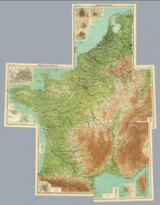
Composite: France, Belgium, Holland.
1 : 1000000 John Bartholomew & Co.
Frankreich
Neuer Handatlas über alle Theile der Erde Kiepert, Heinrich Verlag von Dietrich Reimer
Gallia Antiqua. (1826)
1 : 5200000 Tanner, Henry S.
Neue Orientierungkarte [von] Frankreich u[nd] Mittelmeerlä[nder]
Francie
France in provinces.
1 : 3450000 Society for the Diffusion of Useful Knowledge (Great Britain)
Ancient France.
1 : 3500000 Society for the Diffusion of Useful Knowledge (Great Britain)
LA FRANCE en 1812
Francie Las Cases, Emmanuel-Auguste-Dieudonné Didot, Pierre Jules Didot Ainé
Francie, Belgie, Nizozemí, Lucembursko

France.
1 : 4550000 Darton, William
Frankreich
1 : 5000000 Francie Kocen, Blaž Eduard Hölzel
Charte von Frankreich
1 : 2400000 Francie Streit, Friedrich Wilhelm Geograph. Instituts
Charte von Frankreich
1 : 2400000 Francie Streit, Friedrich Wilhelm Geograph. Instituts
Carte Geologique de la Region Francaise.
1 : 2550000 Jouvet et Cie.
Galliae Veteris Typus. [Karte], in: Theatrum orbis terrarum, S. 374.
1 Karte aus Atlas Ortelius, Abraham
France Militaire.
1 : 2550000 Jouvet et Cie.
France Administrative.
1 : 2550000 Jouvet et Cie.
Gallia Antiqua.
1 : 2500000 Anville, Jean Baptiste Bourguignon d, 1697-1782
Frankreich

La France.
1 : 1970000 Levasseur, Victor.
Carte Historique de la Region Francaise.
1 : 2550000 Jouvet et Cie.
France Forestiere.
1 : 2550000 Jouvet et Cie.
France Industrielle et Commerciale.
1 : 2550000 Jouvet et Cie.
Frankreich.
1 : 1865000 Weiland, C. F. (Carl Ferdinand), d. 1847
Carte générale de l'Empire Français et du Royaume d'Italie suivant les nouvelles divisions : avec les chefs-lieux de préfecture et l'indication des principales routes
1 : 2000000 par C.F. Delamarche Barriere sculpsit. À Paris : chez l'auteur
France ... Holland And Belgium.
1 : 1330560 Johnson, A.J.
France.
1 : 3168000 Colton, G.W.
France.
1 : 3180000 Mitchell, Samuel Augustus
Carte de France
1 Karte : Kupferdruck ; 28 x 29 cm s.n.
Nouvelle topographie de la France
1 Karte : Kupferdruck ; 54 x 54 cm Hesseln; Delahaye s.n.