Maps of Germany

Der Deutsche Bund samt der Helvetischen Eidgenossenschaft aft. 1828
Historisch-genealogisch-geographischer Atlas von Le Sage Las Cases, Emmanuel Auguste Dieudonné Marius Joseph de Johann Velten, Kunsthändler
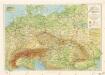
Europe Centrale.
1 : 3000000 Garnier, F. A., 1803-1863
Rozsah moci význačných českých panovníků do XIV. stol.

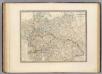
Germany, Austria.
1 : 4118400 Letts, Son & Co.
Carte Politique de L'Europe Centrale.
1 : 3600000 Jouvet et Cie.
Carta generale della Germania ossia Confederazione Germanica.
1 : 3500000 Marzolla, Benedetto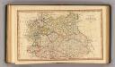
Central states Europe.
1 : 9000000 Fenner, Rest.
Germany
A new general atlas of modern geography, consisting of a complete collection of maps of the four quarters of the globe Wyld, James James Wyld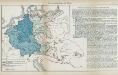
Nr. 8a. Die Germanisierung des Ostens
Ostmitteleuropa Deutsche, Siedlung
Soubor němých map pro střední školy
L'Allemagne, l'Europe centrale.
1 : 3460000 Andriveau-Goujon, J.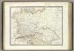
Germanie Ancienne.
1 : 3300000 Lapie, M. (Pierre), 1779-1850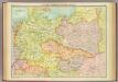
Central European states - political.
1 : 3000000 John Bartholomew and Son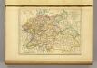
l'Allemagne par Cercles in 1789.
1 : 6300000 Malte-Brun, Conrad, 1775-1826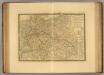
Europe Centrale.
1 : 3500000 Picquet, C.
Sbírka map a diagramů použitých na mírových konferencích v Paříži v letech 1919 - 1920
Příruční mapa střední Evropy
Allemagne.
1 : 3300000 Lapie, M. (Pierre), 1779-1850
Germany general map.
1 : 4300000 Society for the Diffusion of Useful Knowledge (Great Britain)
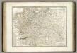
Germany.
1 : 6336000 Finley, Anthony
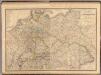
Germany.
1 : 6336000 Lucas, Fielding Jr.
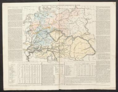
Mittel-Europäische Staaten
Stieler's Hand-Atlas Stieler, Adolf bei Justus Perthes
Mitteleuropa am Ende des 30 jährigen Krieges
Evropa střední F. Tempsky
Mitteleuropa während des 30 jährigen Krieges.
Evropa střední Benecke Bormann, E. F. Tempsky
Közép-Európa
1 : 5000000 Evropa střední Állami kiadóhivatal
Übersichtskarte der Eisenbahnen und Eisen-Bahn-Abstoss-Stationen von Mitteleuropa 1883
Evropa střední W. Koch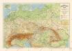
Grossdeutsches Reich und angrenzende Gebiete
Composite: Allemagne.
1 : 2000000 Andriveau-Goujon, J.
Composite Map: Map of the Central States of Europe Situate between France and Russia
1 : 1200000 Faden, William (1749-1836)