Maps of Germany

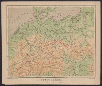
Deutschland
Plastischer Schul-Atlas über alle Theile der Erde : in 24 Karten Woldermann, G Verlag von P. Eckerlein
Post- & Reise-Karte von Deutschland und den nachbar Staaten
Evropa střední Handtke, Friedrich Flemming, C. C. Flemming
Post- & Reise-Karte von Deutschland und den nachbar Staaten
Evropa střední Handtke, Friedrich Weber, H. C. Fleming
Post Karte von Deutschland und den angraenzenden Laendern vorzüglich der preussischen Staaten
1 : 1700000 Evropa střední Mollo, Tranquillo T. Mollo
Germany.
1 : 6400000 Tanner, Henry S.
Tabula Geographica Imperii Germanici
1 : 2100000 Mollova mapová sbírka Rhode, Johann Christoph Berger, Friedrich Gottlieb
Deutschland
Neuer Handatlas über alle Theile der Erde Kiepert, Heinrich Verlag von Dietrich Reimer
Allemagne.
1 : 5000000 Monin, C.V.
Deutschland 1792
Deutschland Kunz, Andreas ; Moeschl, Joachim Robert
Deutschland 1648
Deutschland Kunz, Andreas ; Moeschl, Joachim Robert
Composite: Germany.
1 : 1250000 Robert Laurie & James Whittle
Germany.
1 : 6000000 Finley, Anthony
Germania magna, Rhaetia, Noricum
1 : 3800000 Evropa střední Spruner, Karl von Behrens, W. Justus Perthes
Deutschland 1803 nach dem Reichsdeputationshauptschluss
Deutschland Reichsdeputationshauptschluss Kunz, Andreas ; Moeschl, Joachim Robert
A new map of the German Empire...

Deutschland 1555
Deutschland Kunz, Andreas ; Moeschl, Joachim Robert
Deutschland um 1378
Deutschland Kunz, Andreas ; Moeschl, Joachim Robert
Germania Augustiniana
1 : 3700000 Mollova mapová sbírka Seutter, Matthäus Seutter, Matthäus
Deutschland um 1500
Deutschland Kunz, Andreas ; Moeschl, Joachim Robert
Regenkarte, Mittlere Jahrestemperatur v. Deutschland.
1 : 7000000 Andree, Richard
Sprachenkarte, Religionskarte v. Deutschland.
1 : 7000000 Andree, Richard
Hohenschichtenkarte, Bevolkerungsdichtigkeit.
1 : 7000000 Andree, Richard
Uebersichts-Karte aller in Deutschland

Deutschland, Übersicht des Deutschen Reichs
Handatlas über alle Theile der Erde und über das Weltgebäude Stieler, Adolf Justus Perthes
Post- und Eisenbahn-Reisekarte von Central-Europa
1 : 2000000 Evropa střední Franz, J. Handtke, Friedrich Carl Flemming
Telegrafenlinien, Eisenbahnen und Dampfbootfahrten in Deutschland und den Nachbarstaaten
Evropa střední Raffelsperger, Franz Franz Raffelsperger
Střední Evropa v zájmu světového míru
1 : 5000000 Evropa střední Kuffner, Hanuš
Deutschland physikalisch.
1 : 3400000 Andree, Richard
Post- und Reisekarte von Deutschland, den Niederlanden, Belgien und der Schweiz
1 : 2470000 Belgie Bachmann, Friedrich Nast Friedr. Kornschen Buchhandlung