Maps of Germany
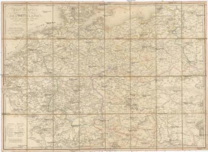
Post Karte von Deutschland und den angraenzenden Laendern vorzüglich der preussischen Staaten
1 : 1700000 Evropa střední Mollo, Tranquillo T. Mollo
Deutschland
Neuer Handatlas über alle Theile der Erde Kiepert, Heinrich Verlag von Dietrich Reimer
Germany.
1 : 6000000 Finley, Anthony
A new map of the German Empire...

Deutschland 1555
Deutschland Kunz, Andreas ; Moeschl, Joachim Robert
Neueste Post-Karte von Deutschland und dem grösten Theil der umliegenden Staaten oder Mittel-Europa
1 : 2350000 Evropa střední Fried, Franz List, C. Artaria
Deutschland 1803 nach dem Reichsdeputationshauptschluss
Deutschland Reichsdeputationshauptschluss Kunz, Andreas ; Moeschl, Joachim Robert
Post- und Eisenbahn-Reisekarte von Central-Europa
1 : 2000000 Evropa střední Franz, J. Handtke, Friedrich Carl Flemming
Deutschland 1648
Deutschland Kunz, Andreas ; Moeschl, Joachim Robert
Deutschland 1792
Deutschland Kunz, Andreas ; Moeschl, Joachim Robert
Allemagne.
1 : 5000000 Monin, C.V.
Deutschland
Plastischer Schul-Atlas über alle Theile der Erde : in 24 Karten Woldermann, G Verlag von P. Eckerlein
Deutschland, Übersicht des Deutschen Reichs
Handatlas über alle Theile der Erde und über das Weltgebäude Stieler, Adolf Justus Perthes
Střední Evropa v zájmu světového míru
1 : 5000000 Evropa střední Kuffner, Hanuš
Allemagne. Politique et économique. n133
1 : 2600000 A. Taride Paris : A.Taride
Telegrafenlinien, Eisenbahnen und Dampfbootfahrten in Deutschland und den Nachbarstaaten
Evropa střední Raffelsperger, Franz Franz Raffelsperger
Post- & Reise-Karte von Deutschland und den nachbar Staaten
Evropa střední Handtke, Friedrich Flemming, C. C. Flemming
Post- & Reise-Karte von Deutschland und den nachbar Staaten
Evropa střední Handtke, Friedrich Weber, H. C. Fleming
Autriche, Prusse, Confed. Germanique, Pologne 1788 a 1841.
1 : 6300000 Houze, Antoine Philippe
Deutschland um 1378
Deutschland Kunz, Andreas ; Moeschl, Joachim Robert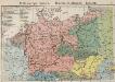
Mitteleuropa. Völker
1 : 9000000 Mitteleuropa Ethnische Gruppe
Post und Eisenbahn Reisekarte von Central Europa

Germania Augustiniana
1 : 3700000 Mollova mapová sbírka Seutter, Matthäus Seutter, Matthäus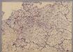
[Mitteleuropa]
1 : 2500000 [S.l. : s.n.]
Germany.
1 : 6400000 Tanner, Henry S.
Deutschland um 1500
Deutschland Kunz, Andreas ; Moeschl, Joachim Robert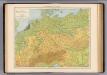
Deutschland physikalisch.
1 : 3400000 Andree, Richard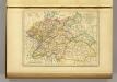
l'Allemagne par Cercles in 1789.
1 : 6300000 Malte-Brun, Conrad, 1775-1826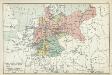
XII. Preußen innerhalb Deutschlands mit den angrenzenden Staatengebieten
1 : 6000000 Mitteleuropa, Deutschland