Maps of Šestajovice

Schestajowitz (Ssestajowice) - c7718-1-002 - Kaiserpflichtexemplar der Landkarten des stabilen Katasters
1 : 2880
Schestajowitz (Ssestajowice) - c7718-1-004 - Kaiserpflichtexemplar der Landkarten des stabilen Katasters
1 : 2880
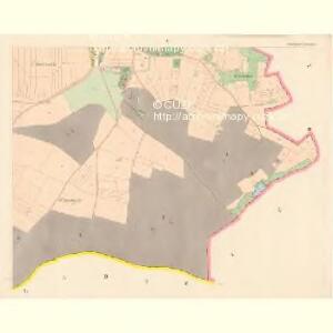
Schestajowitz (Ssestajowice) - c7718-1-001 - Kaiserpflichtexemplar der Landkarten des stabilen Katasters
1 : 2880
Schestajowitz (Ssestajowice) - c7718-1-003 - Kaiserpflichtexemplar der Landkarten des stabilen Katasters
1 : 2880
Gross Girna (Welkych Girna) - c2924-1-005 - Kaiserpflichtexemplar der Landkarten des stabilen Katasters
1 : 2880
Gross Girna (Welkych Girna) - c2924-1-004 - Kaiserpflichtexemplar der Landkarten des stabilen Katasters
1 : 2880
Gross Girna (Welkych Girna) - c2924-1-001 - Kaiserpflichtexemplar der Landkarten des stabilen Katasters
1 : 2880
Gross Girna (Welkych Girna) - c2924-1-003 - Kaiserpflichtexemplar der Landkarten des stabilen Katasters
1 : 2880
Gross Girna (Welkych Girna) - c2924-1-002 - Kaiserpflichtexemplar der Landkarten des stabilen Katasters
1 : 2880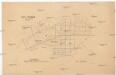
Rev. Neuhof.
1 : 2200 Klánovice (Praha, Česko) Kohut, Josef Líčka, Josef
Ober Potschernitz (Horni Poczernice) - c2122-1-005 - Kaiserpflichtexemplar der Landkarten des stabilen Katasters
1 : 2880
Ober Potschernitz (Horni Poczernice) - c2122-1-003 - Kaiserpflichtexemplar der Landkarten des stabilen Katasters
1 : 2880
Ober Potschernitz (Horni Poczernice) - c2122-1-004 - Kaiserpflichtexemplar der Landkarten des stabilen Katasters
1 : 2880
Ober Potschernitz (Horni Poczernice) - c2122-1-002 - Kaiserpflichtexemplar der Landkarten des stabilen Katasters
1 : 2880
Ober Potschernitz (Horni Poczernice) - c2122-1-001 - Kaiserpflichtexemplar der Landkarten des stabilen Katasters
1 : 2880
Ober Potschernitz (Horni Poczernice) - c2122-1-006 - Kaiserpflichtexemplar der Landkarten des stabilen Katasters
1 : 2880
Zellenetz (Zelenecz) - c9248-1-003 - Kaiserpflichtexemplar der Landkarten des stabilen Katasters
1 : 2880
Zellenetz (Zelenecz) - c9248-1-002 - Kaiserpflichtexemplar der Landkarten des stabilen Katasters
1 : 2880
Zellenetz (Zelenecz) - c9248-1-001 - Kaiserpflichtexemplar der Landkarten des stabilen Katasters
1 : 2880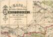
Mapa politického a školního okresu Českobrodského


Mapa půd v okrese Brandýs n./Lab
1 : 38000 Brandýs nad Labem-Stará Boleslav-oblast (Česko) Spirhanzl, J. Srch, J. reprodukce Voj. zeměpisného ústavu
Podrobné mapy zemí Koruny české v měřítku 1:75.000 - Praha - Brandýs n. L. Průvodce statisticko-historický po všech místech na těchto mapách uvedených a rejstřík věcný názvů hor, potoků, řek, rybníků atd. a mapa vzdáleností všech míst při silnici ležících Sešit 1. List 55,
1 : 75000
Plan der Gegend zwischen Nehwizd und Sadska in welcher das Feldlager und Manoeuvre vom 11ten bis 14ten September 1837 statt hat
Sadská-oblast (Česko) Hennig, C. C. Hennig
Podrobné mapy zemí koruny české v měřítku 1:75 000 a průvodce statisticko-historický po všech místech na těchto mapách uvedených. - Praha-Brandýs n. L. List 55
1 : 75000
Eisenbahn Karte Wien-Dresden, Ollmütz-Trübau
1 : 72000 Blatt 13 Minarzik, Anselm J. Rauh
Podrobné mapy zemí Koruny české v měřítku 1:75.000 a mapa vzdáleností všech míst při silnici ležících
1 : 75000 Brandýs nad Labem-Stará Boleslav (Česko : oblast) Bělohlav, Josef F. Topič
Brandýský vikariát
Brandýs nad Labem-Stará Boleslav-oblast (Česko)
Prag Zone 5, Kol. 11
1 : 75000