Maps of Lysá nad Labem

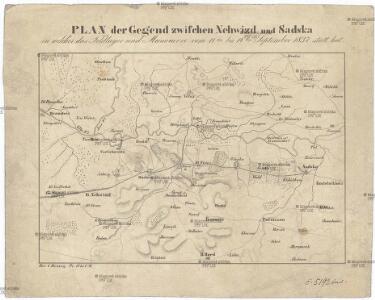
Plan der Gegend zwischen Nehwizd und Sadska in welcher das Feldlager und Manoeuvre vom 11ten bis 14ten September 1837 statt hat
Sadská-oblast (Česko) Hennig, C. C. Hennig
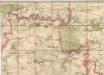
Podrobné mapy zemí Koruny české v měřítku 1:75.000 a mapa vzdáleností všech míst při silnici ležících
1 : 75000 Kouřim (Česko : oblast) Bělohlav, Josef F. Topič
Podrobné mapy zemí Koruny české v měřítku 1:75.000 a mapa vzdáleností všech míst při silnici ležících - Český Brod – Kouřim. Průvodce statisticko-historický po všech místech na těchto mapách uvedených a rejstřík věcný názvů hor, potoků, řek, rybníků atd. Sešit 14. List 68,
1 : 75000
Mapa politického a školního okresu Českobrodského

Gradkartenblatt
1 : 25000 Nymburk-oblast (Česko) Ansion, Victor
III. vojenské mapování 3954/1
1 : 25000
III. vojenské mapování 3954/1
1 : 25000
Bez titulu:Sektion 3953 Brandýs nad Labem, Stará Boleslav

III. vojenské mapování 3953/2
1 : 25000
III. vojenské mapování 3953/2
1 : 25000
Gradkartenblatt
1 : 25000 Brandýs nad Labem-Stará Boleslav-oblast (Česko) Czechák, Carl
Bez titulu: Neu Benatek
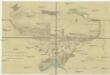
Lager der unterdem Herrn F.M.L. von Goržkowski stehenden Cavalerie Division für die Periode von 10ten bis incl. 15ten September 1838
1 : 24000 Lysá nad Labem-oblast (Česko)
Neu Lissa (Lisa) - c4341-1-010 - Kaiserpflichtexemplar der Landkarten des stabilen Katasters
1 : 2880
Neu Lissa (Lisa) - c4341-1-004 - Kaiserpflichtexemplar der Landkarten des stabilen Katasters
1 : 2880
Neu Lissa (Lisa) - c4341-1-005 - Kaiserpflichtexemplar der Landkarten des stabilen Katasters
1 : 2880
Neu Lissa (Lisa) - c4341-1-001 - Kaiserpflichtexemplar der Landkarten des stabilen Katasters
1 : 2880
Neu Lissa (Lisa) - c4341-1-008 - Kaiserpflichtexemplar der Landkarten des stabilen Katasters
1 : 2880
Neu Lissa (Lisa) - c4341-1-014 - Kaiserpflichtexemplar der Landkarten des stabilen Katasters
1 : 2880
Neu Lissa (Lisa) - c4341-1-011 - Kaiserpflichtexemplar der Landkarten des stabilen Katasters
1 : 2880
Neu Lissa (Lisa) - c4341-1-003 - Kaiserpflichtexemplar der Landkarten des stabilen Katasters
1 : 2880
Neu Lissa (Lisa) - c4341-1-009 - Kaiserpflichtexemplar der Landkarten des stabilen Katasters
1 : 2880
Neu Lissa (Lisa) - c4341-1-006 - Kaiserpflichtexemplar der Landkarten des stabilen Katasters
1 : 2880
Neu Lissa (Lisa) - c4341-1-002 - Kaiserpflichtexemplar der Landkarten des stabilen Katasters
1 : 2880
Neu Lissa (Lisa) - c4341-1-007 - Kaiserpflichtexemplar der Landkarten des stabilen Katasters
1 : 2880
Neu Lissa (Lisa) - c4341-1-013 - Kaiserpflichtexemplar der Landkarten des stabilen Katasters
1 : 2880
Neu Lissa (Lisa) - c4341-1-012 - Kaiserpflichtexemplar der Landkarten des stabilen Katasters
1 : 2880
[Gradkartenblatt]
1 : 25000 Čechy (Česko) Vojenský zeměpisný ústav