Maps of Prague

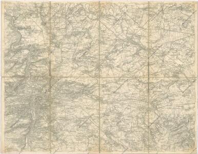
Prag Zone 5, Kol. 11
1 : 75000
III. vojenské mapování 3953
1 : 75000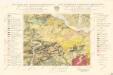
Geologická mapa Československé republiky, list Praha 3953
Mapy plánování ČSR

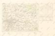
Podrobná mapa okolí Pražského List II.

Podrobná mapa okolí Pražského
1 : 75000 Brandýs nad Labem-Stará Boleslav (Česko : oblast) Hevera, Čeněk Klub československých turistů
Podrobná mapa okolí Pražského
1 : 75000 Brandýs nad Labem-Stará Boleslav (Česko : oblast) Hevera, Čeněk Klub československých turistů
Prag
1 : 75000 Praha (Česko : oblast) Fitz, J. K. u. k. Militärgeographisches Institut
Prag
1 : 75000 Praha (Česko : oblast) K. u. k. Militärgeographisches Institut
Praha
1 : 75000 Praha (Česko : oblast) Vojenský zeměpisný ústav
Vilímkovy místopisné mapy zemí Koruny české
1 : 100000 Praha (Česko : oblast) Srp, Jan Jos. R. Vilímek
Podrobná mapa Království českého
1 : 100000 Praha (Česko : oblast) Srp, Jan Jos. R. Vilímek
Podrobná mapa Království českého
1 : 100000 Praha (Česko : oblast) Srp, Jan Jaroslav Bursík
Eisenbahn Karte Wien-Dresden, Ollmütz-Trübau
1 : 72000 Blatt 13 Minarzik, Anselm J. Rauh
Podrobné mapy zemí koruny české v měřítku 1:75 000 a průvodce statisticko-historický po všech místech na těchto mapách uvedených. - Praha-Brandýs n. L. List 55
1 : 75000
Podrobné mapy zemí Koruny české v měřítku 1:75.000 - Praha - Brandýs n. L. Průvodce statisticko-historický po všech místech na těchto mapách uvedených a rejstřík věcný názvů hor, potoků, řek, rybníků atd. a mapa vzdáleností všech míst při silnici ležících Sešit 1. List 55,
1 : 75000
Podrobné mapy zemí Koruny české v měřítku 1:75.000 a mapa vzdáleností všech míst při silnici ležících
1 : 75000 Brandýs nad Labem-Stará Boleslav (Česko : oblast) Bělohlav, Josef F. Topič
Soubor map okresů Pražského kraje

Spezialkarte der Umgebung von Prag

[Prag und Umgebung]
1 : 57600 Praha (Česko) Carl Bellmann's Verlag
Karte des Karolinenthaler Bezirkes im Prager Kreise
1 : 72000 Karlín (Praha, Česko) Wagner, Jan Eduard in Commission bei Karl André
Karte des Karolinenthaler Bezirkes im Prager Kreise
1 : 72000 Karlín (Praha, Česko) Wagner, Jan Eduard Karl André
Karte des Karolinenthaler Bezirkes im Prager Kreise
1 : 72000 Karlín (Praha, Česko) Wagner, Jan Eduard in Commission bei Karl André
Karte des Karolinenthaler Bezirkes im Prager Kreise
1 : 72000 Karlín (Praha, Česko) Wagner, Jan Eduard in Commission bei Karl André
Karte des Karolinenthaler Bezirkes im Prager Kreise
1 : 72000 Karlín (Praha, Česko) Wagner, Jan Eduard in Commission bei Karl André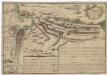
Recht wahrhaffte Vorstellung der den 6ten May A.no 1757 zwischen der kaisserl. und könig. preüss. Armée bey Prag vorgefallenen Bataille
Praha (Česko) Salzer, Ignác
Recht wahrhaffte Vorstellung der den 6ten May A.no 1757 zwischen der kasserl. und könig. preüss. Armée bey Prag vorgefallenen Bataille
Praha (Česko) Salzer, Ignác
Recht wahrhaffte Vorstellung der den 6ten May A.no 1757 zwischen der kaisserl. und könig. preüss. Armée bey Prag vorgefallenen Bataille
Praha (Česko) Salzer, Ignác