Maps of Bayern

[Jižní Německo]
Německo jižní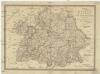
Karte vom Königreiche Baiern, Würtemberg, und dem Grossherzogthume Baden
1 : 1160000 Bavorsko (Německo) Fried, Franz bei Artaria et Comp.
Germany south.
1 : 1840000 Arrowsmith, Aaron; Lewis, Samuel
Germany south.
1 : 1840000 Arrowsmith, Aaron; Lewis, Samuel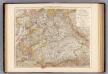
Wurttemberg, Bayern.
1 : 1000000 Andree, Richard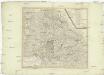
Chur-Bayern im Jahr 1802
1 : 1100000 Bavorsko (Německo) Herdegen, J. C. F. Karel Theodor J.L.C. Rheinwald
Gäntzlicher Schluß aller deren Königl. Hungar. und Böheimischen, Kriegs Progressen lauffenden 1743sten Jahrs In einer Land-Karten bestehen
Mollova mapová sbírka Lidl, Johann Jakob Lidl, Johann Jacob
Baiern mit Ausschluss des Rheinkreises
1 : 1154000 Bavorsko (Německo) Berthe Gleditsch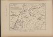
Cesta, kudy Hus ubíral se do Kostnice
Mitteleuropa Konstanz Reiseweg Hus, Jan
Pagus Rangowe
1 Karte : Kupferdruck ; 46 x 55 cm Enderes; Strebel; Schneider zu finden in der Enderesischen Buchhandlung
Serenissimo principi ac domino, domino Alexandro Ferdinando S. R. I. principi de Tour [et] Taxis
1 Karte auf 4 Blatt : Kupferdruck ; Gesamtgrösse 69 x 76 cm Homännische Erben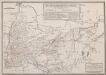
Retraite de Bavière en France, Faite par l'Armée française de Rhin et Moselle, sous les ordres du Général Moreau, Depuis le 10 Septembre jusqu'au 26 Octobre 1796
Haas, Wilhelm
Nördliche Fortsetzung des Rhein von Oppenheim bis Köln
Hand-Atlas über alle Theile der Erde nach dem neuesten Zustande und über das Weltgebäude Stieler, Adolf bei Justus Perthes
Nördliche Fortsetzung des Rhein von Oppenheim bis Köln
Hand-Atlas über alle Theile der Erde nach dem neuesten Zustande und über das Weltgebäude Stieler, Adolf bei Justus Perthes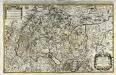
Le cercle de Souabe subdivisé en tous les estats qui le composent
1 Karte auf 2 Blatt : Kupferdruck ; 52 x 85 cm Sanson; Jaillot chez H. Iaillot joignant les Augustins aux deux globes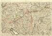
Le Cours du Danube
1 : 440000 Mollova mapová sbírka Jaillot, Alexis-Hubert Jaillot, Alexis Hubert
Übersichtskarte von Mittel - Europa

Mainz, Nürnberg, Strassburg, Ulm
1 : 750000 Hannover (Německo : oblast) Budik, A. K. u. k. Militärgeographisches Institut
Mainz, Nürnberg, Strassburg, Ulm
1 : 750000 Hannover (Německo : oblast) K. k. militär-geographisches Institut
Chur=Baiern
1 Karte : Kupferdruck ; 46 x 55 cm Riegel zu finden bey Christoph Riegel
[Der Rhein vom Boden-See bis Cöln zugleich als Special-Karte von Würtemberg und Baden]
Stieler's Hand-Atlas Stieler, Adolf bei Justus Perthes
Grand theatre de la guerre sur les frontieres de France & d' Allemagne ou carte nouvelle du cours du Rhin et des pais circonvoisins contenant la Haute & Basse Alsace & le Palatinat & les electorats de Mayence, de Treves & une partie de Cologne de Hesse, de Franconie, de Baviere, le cercle de Souable le duché de Wurtenberg, de Brisgaw, de Bade, de Suntgaw & c. & c. & c
Francie Delisle, Guillaume Jean Covens & Corneille Mortier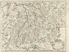
Palatinat du Rhein, Alsace, et Partie de Souabe de Franconie &c.
1 : 870000 Mollova mapová sbírka Sanson, Nicolas Cordier, Robert Sanson, Nicolas
Le Cercle De Souabe subdivisé en tous les Estats qui le composent [Karte], in: Atlas nouveau, contenant toutes les parties du monde [...], Bd. 1, S. 280.
1 Karte aus Atlas Sanson, Nicolas Jaillot, Alexis Hubert und Mortier, Pieter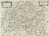
Il Circolo Di Svevia et il Langraviato D'Alsazia
1 : 650000 Mollova mapová sbírka Falda, Giovan Battista Widman, Giorgio De Rossi, Giovanni Giacomo
Le cercle de Souabe divisé en tous les estats qui le composent
1 Karte : Kupferdruck ; 44 x 60 cm Ottens; Jaillot; Ottens chez R. et J. Ottens
Suevia Neue Land-Tafel des Gantzen Schwäbischen Krayses
1 : 880000 Mollova mapová sbírka Sandrart, Jakob von Sandrart, Jacob von
Svevia Tafel Schwaben
1 : 880000 Mollova mapová sbírka Merian, Matthaeus Merian, Matthäus st.
Sveviae Nova Tabvla
1 : 880000 Mollova mapová sbírka Blaeu, Willem Janszoon Blaeu, Willem Jansz.
![[Jižní Německo]](https://images-2.georeferencer.com/images/iiif/141297868236/full/,300/0/native.jpg)

