Maps of Bayern

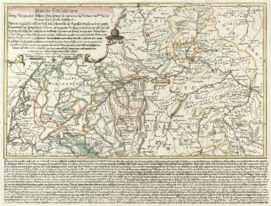
Gäntzlicher Schluß aller deren Königl. Hungar. und Böheimischen, Kriegs Progressen lauffenden 1743sten Jahrs In einer Land-Karten bestehen
Mollova mapová sbírka Lidl, Johann Jakob Lidl, Johann Jacob
Germany south.
1 : 1840000 Arrowsmith, Aaron; Lewis, Samuel
Germany south.
1 : 1840000 Arrowsmith, Aaron; Lewis, Samuel
Chur-Bayern im Jahr 1802
1 : 1100000 Bavorsko (Německo) Herdegen, J. C. F. Karel Theodor J.L.C. Rheinwald
Circvlvs Bavariae Compositus ex Ducatu Bavariae, Palatinatu superiore ceteris que Territoriis emmediatis ecclesiasticis et Secularibus
1 : 2100000 Mollova mapová sbírka Franz, Johann Michael Homann, Johann Baptista - dědici
Karte vom Königreiche Baiern, Würtemberg, und dem Grossherzogthume Baden
1 : 1160000 Bavorsko (Německo) Fried, Franz bei Artaria et Comp.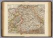
Wurtemberg, Bavaria.
1 : 1000000 Andree, Richard; Times (London, England)
Germany No. 3.
1 : 1500000 Colton, G.W.
[Neuer Atlas der ganzen Erde nach den neuesten Bestimmungen ... : XVII.] Die Königreiche Baiern u. Würtemberg, das Grossherzogthum Baden und die Fürstl. Hohenzollernschen Laender
Entworfen und gezeichnet von Dr. F.W. Streit H. Leutemann sc. Leipzig : J.C. Hinrichssche Buchhandlung
Baiern, Wurtemberg, Baden u. Hohenzollern.
1 : 980000 Streit, F. W.
Salisbvrgensis Ivrisdictionis, locorumque vicinorum vera descriptio
1 : 730000 Mollova mapová sbírka Setznagel, Marx Rade, Gillis van den
Das Königreich Bayern
1 : 850000 Bavorsko (Německo) Weiland, Karl Ferdinand Geographisches Institut
Baiern mit Ausschluss des Rheinkreises
1 : 1154000 Bavorsko (Německo) Berthe Gleditsch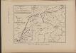
Cesta, kudy Hus ubíral se do Kostnice
Mitteleuropa Konstanz Reiseweg Hus, Jan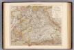
Wurttemberg, Bayern.
1 : 1000000 Andree, Richard
Geschäfts-Uebersichtskarte des Steuer-Katasters bis zum Schlusse des Jahres 18..
1 : 800000 K. Stiglmayer Contur gravirt J. Obernetter Schrift gravirt [S.l.] : [s.n.]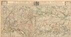
Le Théatre De La Guerre En Allemagne
1 : 490000 Mollova mapová sbírka Liébaux, Jean-Baptiste Bénard, Jacques-François
Chur=Baiern
1 Karte : Kupferdruck ; 46 x 55 cm Riegel zu finden bey Christoph Riegel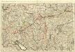
Le Cours du Danube
1 : 440000 Mollova mapová sbírka Jaillot, Alexis-Hubert Jaillot, Alexis Hubert
Composite: Bayern.
1 : 650000 Radefeld, Carl Christian Franz, 1788-1874
[Jižní Německo]
Německo jižní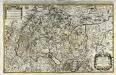
Le cercle de Souabe subdivisé en tous les estats qui le composent
1 Karte auf 2 Blatt : Kupferdruck ; 52 x 85 cm Sanson; Jaillot chez H. Iaillot joignant les Augustins aux deux globes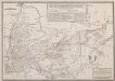
Retraite de Bavière en France, Faite par l'Armée française de Rhin et Moselle, sous les ordres du Général Moreau, Depuis le 10 Septembre jusqu'au 26 Octobre 1796
Haas, Wilhelm
Nördliche Fortsetzung des Rhein von Oppenheim bis Köln
Hand-Atlas über alle Theile der Erde nach dem neuesten Zustande und über das Weltgebäude Stieler, Adolf bei Justus Perthes
Sveviae Nova Tabvla
1 : 880000 Mollova mapová sbírka Walter, Anton Walter, Anton
Nördliche Fortsetzung des Rhein von Oppenheim bis Köln
Hand-Atlas über alle Theile der Erde nach dem neuesten Zustande und über das Weltgebäude Stieler, Adolf bei Justus Perthes
Le theatre de la guerre d'Allemagne dans les cercles de Baviere de Souabe de Franconie [et]c
1 Karte : Kupferdruck ; 45 x 53 cm Reichelt; Berey chez Berey graveur rue St. Jacque devant la fontaine St. Severin a la princesse de Savoye
Sueviae Nova Tabula. [Karte], in: Novus Atlas, das ist, Weltbeschreibung, Bd. 1, S. 234.
1 Karte aus Atlas Blaeu, Joan Blaeu, Willem Janszoon
Cercle de Baviere
1 : 1100000 Bavorsko (Německo) Mentelle, Edme Tardieu, Pierre François