Maps of Baden-Württemberg
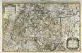
Le cercle de Souabe subdivisé en tous les estats qui le composent
1 Karte auf 2 Blatt : Kupferdruck ; 52 x 85 cm Sanson; Jaillot chez H. Iaillot joignant les Augustins aux deux globes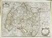
Le cercle de Souabe subdivisé en tous les estats qui le composent
1 Karte : Kupferdruck ; 45 x 64 cm Sanson; Jaillot; Cordier; Simonneau chez H. Iaillot geographe de sa Majesté joignant les grands Augustins aux 2 globes
Le cercle de Souabe divisé en tous les estats qui le composent
1 Karte : Kupferdruck ; 44 x 60 cm Jaillot Alexis-Hubert Jaillot
Le Cercle De Souabe subdivisé en tous les Estats qui le composent [Karte], in: Atlas nouveau, contenant toutes les parties du monde [...], Bd. 1, S. 280.
1 Karte aus Atlas Sanson, Nicolas Jaillot, Alexis Hubert und Mortier, Pieter
Le cercle de Souabe divisé en tous les estats qui le composent
1 Karte : Kupferdruck ; 44 x 60 cm Ottens; Jaillot; Ottens chez R. et J. Ottens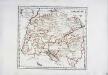
Der schwæbische Kreis
1 Karte : Kupferdruck ; 26 x 29 cm Reilly F. J. J. von Reilly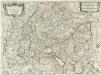
Il Circolo Di Svevia et il Langraviato D'Alsazia
1 : 650000 Mollova mapová sbírka Falda, Giovan Battista Widman, Giorgio De Rossi, Giovanni Giacomo
Sveviae Nova Tabvla
1 : 880000 Mollova mapová sbírka Walter, Anton Walter, Anton
Circvlvs Bavariae Compositus ex Ducatu Bavariae, Palatinatu superiore ceteris que Territoriis emmediatis ecclesiasticis et Secularibus
1 : 2100000 Mollova mapová sbírka Franz, Johann Michael Homann, Johann Baptista - dědici
Bayern, Wurtemberg, Baden, Hohenzollern.
1 : 1500000 Meyer, Joseph, 1796-1856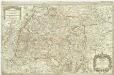
Le cercle de Souabe subdivisé en touts les estats quile composent
1 : 310000 Švábsko (Německo) Sanson, Guillaume Jaillot, Alexis-Hubert H. Ialliot
Sueviae Nova Tabula. [Karte], in: Novus Atlas, das ist, Weltbeschreibung, Bd. 1, S. 234.
1 Karte aus Atlas Blaeu, Joan Blaeu, Willem Janszoon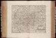
Totivs Sveviae novissima Tabvla
1 : 880000 Annotatie: Gegevens uitgever in cartouche linksonder sterk vervaagd; Origineel is Blad 119 in atlas factice; Vermelding in rechter bovenhoek: II; Annotatie geografische gegevens: Schaalstokken op kaart: Milliaria Germanica communia, en: Milliaria Gallica communia; In linker bovenhoek: legenda [Oxford] : [sumptibus Janssonio-Waesbergii, Mosis Pitt et Stephani Swart]
Sueviae Nova Tabula. [Karte], in: Le théâtre du monde, ou, Nouvel atlas contenant les chartes et descriptions de tous les païs de la terre, Bd. 1, S. 263.
1 Karte aus Atlas Blaeu, Willem Janszoon und Blaeu, Joan Blaeu, Willem Janszoon
Germany Southern.
1 : 1000000 Hall, S. (Sidney)
Nördliche Fortsetzung des Rhein von Oppenheim bis Köln
Hand-Atlas über alle Theile der Erde nach dem neuesten Zustande und über das Weltgebäude Stieler, Adolf bei Justus Perthes
Sueviae Nova Tabula. [Karte], in: Theatrum orbis terrarum, sive, Atlas novus, Bd. 1, S. 277.
1 Karte aus Atlas Blaeu, Joan Blaeu, Willem Janszoon
Nördliche Fortsetzung des Rhein von Oppenheim bis Köln
Hand-Atlas über alle Theile der Erde nach dem neuesten Zustande und über das Weltgebäude Stieler, Adolf bei Justus Perthes
S. R. I. Sueviæ circulus et ducatus
1 Karte : Kupferdruck ; 47 x 56 cm Wit ex officina I. Cóvens et C. Mortier
S. R. I. Sueviæ circulus et ducatus
1 Karte : Kupferdruck ; 47 x 56 cm Wit F. de Witt
Suevia Neue Land-Tafel des Gantzen Schwäbischen Krayses
1 : 880000 Mollova mapová sbírka Sandrart, Jakob von Sandrart, Jacob von
Svevia Tafel Schwaben
1 : 880000 Mollova mapová sbírka Merian, Matthaeus Merian, Matthäus st.
Sveviae Nova Tabvla
1 : 880000 Mollova mapová sbírka Blaeu, Willem Janszoon Blaeu, Willem Jansz.
Reise-Karte von Schwaben
1 Karte : Kupferdruck ; 24 x 35 cm Amman; Staedelen; Stettin im Verlag der Stettinischen Buchhandlung
Circulus Svevicus
1 Karte : Kupferdruck ; 46 x 65 cm Kraus; Wagner; Wille sumtibus Matthæi Wagner
[Neuer Atlas der ganzen Erde nach den neuesten Bestimmungen ... : XVII.] Die Königreiche Baiern u. Würtemberg, das Grossherzogthum Baden und die Fürstl. Hohenzollernschen Laender
Entworfen und gezeichnet von Dr. F.W. Streit H. Leutemann sc. Leipzig : J.C. Hinrichssche Buchhandlung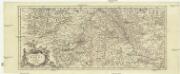
Totius fluminis Rheni novissima descriptio
Rýn, řeka-oblast Wit, Frederick de Frederick de Witt
Totius Sueviae novissima Tabula [Karte], in: Novus atlas absolutissimus, Bd. 2, S. 214.
1 Karte aus Atlas Janssonius Offizin
Circulus Suevicus in quo sunt ducatus Wirtenbergensis
1 Karte : Kupferdruck ; 48 x 57 cm Danckerts Theodorus Danckerts