Maps of Regierungsbezirk Stuttgart

Serenissimo principi ac domino, domino Alexandro Ferdinando S. R. I. principi de Tour [et] Taxis
1 Karte auf 4 Blatt : Kupferdruck ; Gesamtgrösse 69 x 76 cm Homännische Erben
Der Fraenkische Kreis

Pagus Rangowe
1 Karte : Kupferdruck ; 46 x 55 cm Enderes; Strebel; Schneider zu finden in der Enderesischen Buchhandlung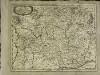
Franconia
1 Karte : Kupferdruck ; 28 x 36 cm Sandrart Jakob von Sandrart
Franconia
1 Karte : Kupferdruck ; 28 x 37 cm Merian
Franconiae Nova Descriptio. [Karte], in: Novus atlas absolutissimus, Bd. 2, S. 174.
1 Karte aus Atlas Janssonius Offizin
Franconia, Neue verbesserte Carten des Gantzen Fränkischen Kraÿses
1 : 740000 Mollova mapová sbírka Merian, Matthaeus Sandrart, Jakob von Sandrart, Jacob von
Franconia, Newe Carten Des Gantzen Fränckischen Krayses
1 : 740000 Mollova mapová sbírka Merian, Matthaeus Merian, Matthäus
Tabula Nova Circuli Franconici, cum omnibus suis limitibus ab Anno XXXVIII. hujusd. Seculi constructa, III. post Annis evulgata /
1 : 260000 Mollova mapová sbírka Endter, Wolfgang Moritz Eimmart, Georg Christoph Endter, Wolfgang Moritz
Franconiæ nova descriptio
1 Karte : Kupferdruck ; 40 x 52 cm Janssonius; Rittershausen Johannes Janssonius excud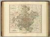
Franconia.
1 : 585000 Cary, John, ca. 1754-1835
Charte vom Fränkischen Kreise
1 Karte : Kupferdruck ; 44 x 53 cm Güssefeld im Verlage des Industrie-Comptoirs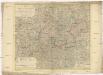
Der Fraenkische Kreis nebst den angraenzenden Laendern
1 : 350000 Franky (Německo) Hammer, C. F. Lochner, Carl Frid. im Verlag der kaiserlich privilegirten Hommanischen Handlung
Franconiae Nova Descriptio.
1 : 620000 Mollova mapová sbírka Rittershausen, Nicolaus
Grundrichtiger Entwurff des gantzen Franckenlandes
1 : 620000 Mollova mapová sbírka Rittershausen, Nicolaus Hipschmann, Sigmund Gabriel Hoffmann, Johann
Charte von dem Fränkischen Kreise
1 Karte : Kupferdruck ; 43 x 51 cm Kreibich im Verlage des Landes-Industrie-Comptoirs
Circulus Franconicus
1 Karte : Kupferdruck ; 48 x 56 cm Lotter Tobias Konrad Lotter
Fränkischer Kreis
Allgemeiner Atlas [Walch, Johannes] im Verlag bei Johannes Walch
Charte von dem Fränkischen Kreise
1 : 569000 Franky (Německo) Kreibich, František Jakub Jindřich im Verlage des L. Ind. Compt.
Charte von dem nordwestlichen Theile des Königreichs Bayern, dem Grossherzogthume Würzburg, dem Fürstenthume Aschaffenburg [et]c.c., oder der Maÿn
1 Karte : Kupferdruck ; 43 x 51 cm Kreibich im Verlage des Geographischen Instituts
Charte vom Fränkischen Kreise
1 : 538200 Franky (Německo) Güssefeld, Franz L. im Verlage des Industrie-Comptoirs
Avstrasiorvm sive Franciae orientalis dvcatvs cvm pago Thvringiae avstralis, in svos pagos singvlares svb imperatoribvs Francicis et Saxonicis ex variis medii aevi diplomatibvs chartis ac docvmentis descriptvs
Durynsko (Německo)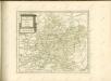

Cercle de Franconie
1 Karte : Kupferdruck ; 47 x 55 cm Robert de Vaugondy; Haussard G. et D. Robert de Vaugondy
Charte von Franken
1 Karte : Kupferdruck ; 43 x 51 cm Kreibich im Verlage des Geographischen Instituts
Der Fraenkische Kreis
1 Karte : Kupferdruck ; 44 x 54 cm Güssefeld; Schmidt bey denen Homaennischen Erben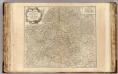
Franconie.
1 : 485000 Robert de Vaugondy, Gilles, 1688-1766
Der Frænkische Kreis nebst den angraenzenden Laendern
1 Karte : Kupferdruck ; 59 x 69 cm Hammer; Lochner im Verlag der kaiserlich privilegierten Homännischen Handlung
Franconia Vulgo Franckenlandt. [Karte], in: Le théâtre du monde, ou, Nouvel atlas contenant les chartes et descriptions de tous les païs de la terre, Bd. 1, S. 178.
1 Karte aus Atlas Blaeu, Willem Janszoon und Blaeu, Joan Blaeu, Willem Janszoon
![Serenissimo principi ac domino, domino Alexandro Ferdinando S. R. I. principi de Tour [et] Taxis](http://biblio.unibe.ch/web-apps/maps/zoomify.php?pic=Ryh_4901_56.jpg&col=ryh)

