Maps of Hesse

Charte von dem nordwestlichen Theile des Königreichs Bayern, dem Grossherzogthume Würzburg, dem Fürstenthume Aschaffenburg [et]c.c., oder der Maÿn
1 Karte : Kupferdruck ; 43 x 51 cm Kreibich im Verlage des Geographischen Instituts
Charte von dem Fränkischen Kreise
1 Karte : Kupferdruck ; 43 x 51 cm Kreibich im Verlage des Landes-Industrie-Comptoirs
Le Cercle de Franconie
1 : 600000 Mollova mapová sbírka Jaillot, Alexis-Hubert Ottens, Josua
Le Cercle de Franconie
1 : 600000 Mollova mapová sbírka Jaillot, Alexis-Hubert Jaillot, Alexis Hubert
Der Frænkische Kreis nebst den angraenzenden Laendern
1 Karte : Kupferdruck ; 59 x 69 cm Hammer; Lochner im Verlag der kaiserlich privilegierten Homännischen Handlung
Fränkischer Kreis
Allgemeiner Atlas [Walch, Johannes] im Verlag bei Johannes Walch
Charte von Franken
1 Karte : Kupferdruck ; 43 x 51 cm Kreibich im Verlage des Geographischen Instituts
Le Cercle de Franconie subdivisé en touts les Estats qui le composent
1 : 510000 Mollova mapová sbírka Sanson, Guillaume Jaillot, Alexis Hubert
Cercle de Franconie
1 Karte : Kupferdruck ; 46 x 54 cm Robert de Vaugondy; Remondini; Santini chez Mr. Remondini
Der Fraenkische Kreis
1 Karte : Kupferdruck ; 44 x 54 cm Güssefeld; Schmidt bey denen Homaennischen Erben
Circulus Franconiae
1 : 500000 Mollova mapová sbírka Hoffmann, Johannes Recknagel, B. Hofmann, Johann
Le cercle de Franconie
1 Karte : Kupferdruck ; 44 x 59 cm Jaillot; Ottens; Ottens chez R. et J. Ottens
Le cercle de Franconie
1 Karte : Kupferdruck ; 44 x 59 cm Jaillot Alexis-Hubert Jaillot
Franconiæ nova descriptio
1 Karte : Kupferdruck ; 40 x 52 cm Janssonius; Rittershausen Johannes Janssonius excud
Cercle de Franconie
1 Karte : Kupferdruck ; 40 x 49 cm Sanson; Mariette chez Pierre Mariette rue St. Iacques a l'Esperance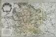
Le cercle de Franconie
1 Karte auf 2 Blatt : Kupferdruck ; 53 x 85 cm Jaillot; Sanson; Chauveau chez H. Iaillot joignant les grands Augustins aux deux globes
Circulus Franconicus
1 Karte : Kupferdruck ; 47 x 57 cm Valck; Valck Valck
Der Fraenkische Kreis
1 : 530000 Franky (Německo) Güssefeld, Franz L. bey denen Homaennischen Erben
Der Fraenkische Kreis
1 : 530000 Franky (Německo) Güssefeld, Franz L. Schmidt, I. M. bey denen Homaennischen Erben
Der Fraenkische Kreis
1 : 530000 Franky (Německo) Güssefeld, Franz L. Schmidt, I. M. Homaennischen Erben
Der Fraenkische Kreis
1 : 530000 Franky (Německo) Güssefeld, Franz L. Schmidt, I. M. bey denen Homaennischen Erben
Franconia
1 : 950000 Mollova mapová sbírka Vogel
Circulus Franconiae divisus in certas ditiones
1 : 510000 Francie Sanson, Guillaume Hoffmann, Johann apud Johannem Hoffmanum
Franconia.
1 : 585000 Cary, John, ca. 1754-1835
Circulus Franconicus
1 Karte : Kupferdruck ; 47 x 56 cm Wit Frederick de Wit
Le cercle de Franconie
1 : 570000 Franky (Německo) Sanson, Guillaume Cordier, Louis Iaillot
Le cercle de Franconie
1 Karte auf 2 Blatt : Kupferdruck ; 52 x 84 cm Jaillot; Sanson chez H. Iaillot joignant les grands Augustins aux deux globes
Le Cercle De Franconie subdivisé entous les Estats qui le composent [Karte], in: Atlas nouveau, contenant toutes les parties du monde [...], Bd. 1, S. 275.
1 Karte aus Atlas Sanson, Nicolas Jaillot, Alexis Hubert und Mortier, Pieter
Avstrasiorvm sive Franciae orientalis dvcatvs cvm pago Thvringiae avstralis, in svos pagos singvlares svb imperatoribvs Francicis et Saxonicis ex variis medii aevi diplomatibvs chartis ac docvmentis descriptvs
Durynsko (Německo)
![Charte von dem nordwestlichen Theile des Königreichs Bayern, dem Grossherzogthume Würzburg, dem Fürstenthume Aschaffenburg [et]c.c., oder der Maÿn](http://biblio.unibe.ch/web-apps/maps/zoomify.php?pic=Ryh_4901_43_B.jpg&col=ryh)

