Maps of Hesse
Circulus Franconiae divisus in certas ditiones
1 : 510000 Francie Sanson, Guillaume Hoffmann, Johann apud Johannem Hoffmanum
Le cercle de Franconie
1 : 570000 Franky (Německo) Sanson, Guillaume Cordier, Louis Iaillot
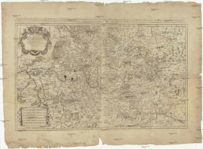
Le Cercle de Franconie subdivisé en touts les Estats qui le composent
1 : 510000 Mollova mapová sbírka Sanson, Guillaume Jaillot, Alexis Hubert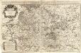
Circulus Franconiae
1 : 500000 Mollova mapová sbírka Hoffmann, Johannes Recknagel, B. Hofmann, Johann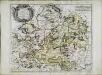
Cercle de Franconie
1 Karte : Kupferdruck ; 40 x 49 cm Sanson; Mariette chez Pierre Mariette rue St. Iacques a l'Esperance
Circulus Franconicus
1 Karte : Kupferdruck ; 47 x 56 cm Wit Frederick de Wit
Das Herzogthum Ostfranken in seine Gauen eingetheilt
1 : 771000 Franky (Německo) Spruner, Karl von Rössert, Josef
Das Herzogthum Ostfranken in seine Gauen eingetheilt
1 : 771000 Franky (Německo) Spruner, Karl von Rössert, Joseph
Le Cercle De Franconie subdivisé entous les Estats qui le composent [Karte], in: Atlas nouveau, contenant toutes les parties du monde [...], Bd. 1, S. 275.
1 Karte aus Atlas Sanson, Nicolas Jaillot, Alexis Hubert und Mortier, Pieter
Der Fraenkische Kreis
1 Karte : Kupferdruck ; 44 x 54 cm Güssefeld; Schmidt bey denen Homaennischen Erben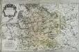
Le cercle de Franconie
1 Karte auf 2 Blatt : Kupferdruck ; 53 x 85 cm Jaillot; Sanson; Chauveau chez H. Iaillot joignant les grands Augustins aux deux globes
Der Frænkische Kreis nebst den angraenzenden Laendern
1 Karte : Kupferdruck ; 59 x 69 cm Hammer; Lochner im Verlag der kaiserlich privilegierten Homännischen Handlung
Franconiæ nova descriptio
1 Karte : Kupferdruck ; 40 x 52 cm Janssonius; Rittershausen Johannes Janssonius excud
Cercle de Franconie
1 Karte : Kupferdruck ; 46 x 54 cm Robert de Vaugondy; Remondini; Santini chez Mr. Remondini
Circulus Franconicus
1 Karte : Kupferdruck ; 47 x 57 cm Valck; Valck Valck
Circulus Franconicus
1 Karte : Kupferdruck ; 47 x 55 cm Wit ex officina I. Covens et C. Mortier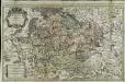
Le cercle de Franconie
1 Karte auf 2 Blatt : Kupferdruck ; 52 x 84 cm Jaillot; Sanson chez H. Iaillot joignant les grands Augustins aux deux globes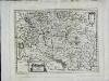
Franconia vulgo Franckenlandt
1 Karte : Kupferdruck ; 26 x 34 cm Merian M. Merian ex
Le Cercle de Franconie
1 : 600000 Mollova mapová sbírka Jaillot, Alexis-Hubert Ottens, Josua
Le Cercle de Franconie
1 : 600000 Mollova mapová sbírka Jaillot, Alexis-Hubert Jaillot, Alexis Hubert
Charte von dem Fränkischen Kreise
1 Karte : Kupferdruck ; 43 x 51 cm Kreibich im Verlage des Landes-Industrie-Comptoirs
Fränkischer Kreis
Allgemeiner Atlas [Walch, Johannes] im Verlag bei Johannes Walch
Charte von dem nordwestlichen Theile des Königreichs Bayern, dem Grossherzogthume Würzburg, dem Fürstenthume Aschaffenburg [et]c.c., oder der Maÿn
1 Karte : Kupferdruck ; 43 x 51 cm Kreibich im Verlage des Geographischen Instituts
Franconia
1 : 950000 Mollova mapová sbírka Vogel
Strassen- und Eisenbahnkarte des oesterreichischen Kaiserthumes
1 : 864000 Blatt 1 Schaller, G. K.K. Militärisch-Geografisches Institut, Karten-Evidenthaltungs-Abteilung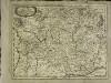
Franconia
1 Karte : Kupferdruck ; 28 x 36 cm Sandrart Jakob von Sandrart
Franconia
1 Karte : Kupferdruck ; 28 x 37 cm Merian
Franckenlandt. Francia orientalis. [Karte], in: Gerardi Mercatoris Atlas, sive, Cosmographicae meditationes de fabrica mundi et fabricati figura, S. 382.
1 Karte aus Atlas Mercator, Gerhard Montanus, Petrus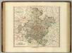
Franconia.
1 : 585000 Cary, John, ca. 1754-1835