Maps of Lower Franconia

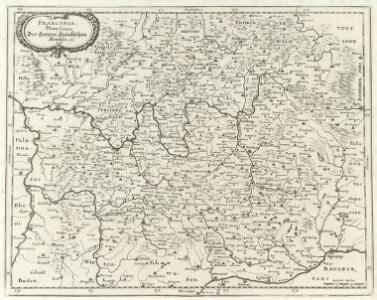
Franconia, Neue verbesserte Carten des Gantzen Fränkischen Kraÿses
1 : 740000 Mollova mapová sbírka Merian, Matthaeus Sandrart, Jakob von Sandrart, Jacob von
Franconia, Newe Carten Des Gantzen Fränckischen Krayses
1 : 740000 Mollova mapová sbírka Merian, Matthaeus Merian, Matthäus
Der Fraenkische Kreis
1 : 530000 Franky (Německo) Güssefeld, Franz L. bey denen Homaennischen Erben
Der Fraenkische Kreis
1 : 530000 Franky (Německo) Güssefeld, Franz L. Schmidt, I. M. bey denen Homaennischen Erben
Der Fraenkische Kreis
1 : 530000 Franky (Německo) Güssefeld, Franz L. Schmidt, I. M. Homaennischen Erben
Der Fraenkische Kreis
1 : 530000 Franky (Německo) Güssefeld, Franz L. Schmidt, I. M. bey denen Homaennischen Erben
Charte von dem nordwestlichen Theile des Königreichs Bayern, dem Grossherzogthume Würzburg, dem Fürstenthume Aschaffenburg [et]c.c., oder der Maÿn
1 Karte : Kupferdruck ; 43 x 51 cm Kreibich im Verlage des Geographischen Instituts
Le Cercle de Franconie
1 : 600000 Mollova mapová sbírka Jaillot, Alexis-Hubert Ottens, Josua
Le Cercle de Franconie
1 : 600000 Mollova mapová sbírka Jaillot, Alexis-Hubert Jaillot, Alexis Hubert
Der Frænkische Kreis nebst den angraenzenden Laendern
1 Karte : Kupferdruck ; 59 x 69 cm Hammer; Lochner im Verlag der kaiserlich privilegierten Homännischen Handlung
Charte von dem Fränkischen Kreise
1 Karte : Kupferdruck ; 43 x 51 cm Kreibich im Verlage des Landes-Industrie-Comptoirs
Circulus Franconicus
1 Karte : Kupferdruck ; 47 x 57 cm Valck; Valck Valck
Der Fraenkische Kreis nebst den angraenzenden Laendern
1 : 350000 Franky (Německo) Hammer, C. F. Lochner, Carl Frid. im Verlag der kaiserlich privilegirten Hommanischen Handlung
Der Fraenkische Kreis
1 Karte : Kupferdruck ; 44 x 54 cm Güssefeld; Schmidt bey denen Homaennischen Erben
Le Cercle de Franconie subdivisé en touts les Estats qui le composent
1 : 510000 Mollova mapová sbírka Sanson, Guillaume Jaillot, Alexis Hubert
Fränkischer Kreis
Allgemeiner Atlas [Walch, Johannes] im Verlag bei Johannes Walch
Franconia vulgo Franckenlandt
1 Karte : Kupferdruck ; 37 x 48 cm Blaeu excudit Guiljelmus Blaeu
Charte von Franken
1 Karte : Kupferdruck ; 43 x 51 cm Kreibich im Verlage des Geographischen Instituts
Cercle de Franconie
1 Karte : Kupferdruck ; 46 x 54 cm Robert de Vaugondy; Remondini; Santini chez Mr. Remondini
Electoratus Moguntinus...

Charte vom Fränkischen Kreise
1 Karte : Kupferdruck ; 44 x 53 cm Güssefeld im Verlage des Industrie-Comptoirs
Franconiae Nova Descriptio. [Karte], in: Novus atlas absolutissimus, Bd. 2, S. 174.
1 Karte aus Atlas Janssonius Offizin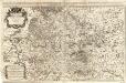
Circulus Franconiae
1 : 500000 Mollova mapová sbírka Hoffmann, Johannes Recknagel, B. Hofmann, Johann
Franconiae Nova Descriptio.
1 : 620000 Mollova mapová sbírka Rittershausen, Nicolaus
Grundrichtiger Entwurff des gantzen Franckenlandes
1 : 620000 Mollova mapová sbírka Rittershausen, Nicolaus Hipschmann, Sigmund Gabriel Hoffmann, Johann
Charte vom Fränkischen Kreise
1 : 538200 Franky (Německo) Güssefeld, Franz L. im Verlage des Industrie-Comptoirs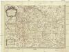
Le cercle de Franconie
1 : 570000 Franky (Německo) Sanson, Guillaume Cordier, Louis Iaillot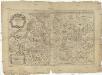
Circulus Franconiae divisus in certas ditiones
1 : 510000 Francie Sanson, Guillaume Hoffmann, Johann apud Johannem Hoffmanum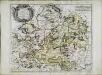
Cercle de Franconie
1 Karte : Kupferdruck ; 40 x 49 cm Sanson; Mariette chez Pierre Mariette rue St. Iacques a l'Esperance