Maps of Czech Republic

Mappa geographica totius Regni Bohemiae in 12. circulos divisae, annexis comitatu Glacensi et districtu Egerano nec non aliis principatib. finitimis
1 : 730000 Kladsko-oblast (Polsko) Lotter, Tobias Conrad T. C. Lotter
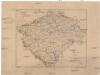
Králowstwí České
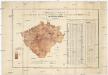
Uebersichts-Karte und statistische Darstellung der Area und der Grundsteuer-Vorschreibung des landtäflichen Grossgrundbesitzes dann des Grundbesitzes überhaupt im Königreiche Böhmen
České království Procházka, Johann F. Joh. F. Procházka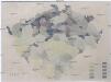
[Mapa hustoty železniční sítě v Čechách]
1 : 1000000 Čechy (Česko) Novák, Fr.
Králowstwí České
Jireček, Josef
Isochronická mapa Čech s úvodem o isochronii vůbec
Karte der Verbreitung der Torfmoore in Böhmen
Česko Sitenský, František Ladislav Kořistka, Karel František Edvard
Království České
1 : 600000 Česko Gräf, K. Müller, A. Výmarský ústav zeměpisný
Království České
1 : 600000 Čechy (Česko) Gräf, K. Biedermann, E. Ústav zeměpisný
Království České
1 : 600000 Čechy (Česko) Gräf, K. Biedermann, E. Ústav zeměpisný
Království České
1 : 600000 Česko Gräf, K. Müller, A. Výmarský ústav zeměpisný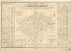
Orientirungs - Karte in der neuen gerichtlichen und politischen Eintheilung des Königreichs Böhmen

Bohemia in XVI circulos divisa, notitiis plurimis illustrata
1 : 350000 Česko Bock-Polach, Josef Ferdinand Müller, Johann Christoph Artaria

Automobil-Karte von Böhmen
1 : 560000 Čechy (Česko) Bayer, J. L Klement's Nachfolger
Mapa Českého království
1 : 418000
Post Charte vom Königreiche Böhmen
1 : 1200000 Česko
Post Charte vom Königreiche Böhmen
1 : 1200000 Česko
Post charte vom Königreiche Böhmen
1 : 1200000 Česko
Post charte vom Königreiche Böhmen
1 : 1200000 Česko
Post Charte vom Königreiche Böhmen
1 : 1200000 Česko
Post Charte vom Königreiche Böhmen
1 : 1200000 Česko
Post Charte vom Königreiche Böhmen
1 : 1200000 Česko
Post Charte vom Königreiche Böhmen
1 : 1200000 Česko
Post Charte vom Königreiche Böhmen
1 : 1200000 Česko
Post Charte vom Königreiche Böhmen
1 : 1200000 Česko
Země česká
1 : 1000000 Krkonoše (Česko a Polsko) Machát, František V. Neubert a synové
Mappa totius regni Bohemiae
1 : 700000 Čechy (Česko) Bock-Polach, Josef Ferdinand Müller, Johann Christoph
Mappa totius regni Bohemiae
1 : 700000 Čechy (Česko) Bock-Polach, Josef Ferdinand Ponheimer, Kilian


