Maps of Spain

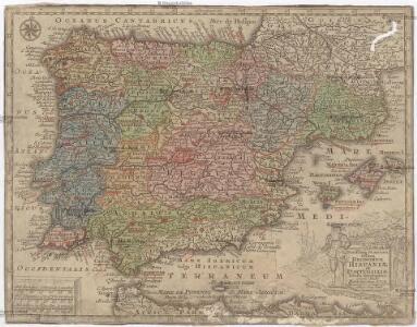
Novissima et accuratißima regnorum Hispaniae et Portugaliae tabella geographica
1 : 6170000 Portugalsko Seutter, Matthäus Lotter, Tobias Conrad Tob. Conr. Lotter
Carte d'Espagne et de Portugal
1 Karte auf 6 Blatt : Kupferdruck ; 73 x 82 cm Brion de la Tour; Jean chez Jean rue Jean de Beauvais. no. 10
L'Espagne 585 a 756.
1 : 4800000 Houze, Antoine Philippe
Le royaume d'Espagne et celui de Portugal
1 : 19300000 Portugalsko Bonne, Rigobert André
Espagne et Portugal 1640 a 1840.
1 : 4800000 Houze, Antoine Philippe
Regnorum Hispaniae et Portugalliae
1 : 2540000 Portugalsko Homann, Johann Baptist a Ioh. Bapt Homanno
Hispania
1 : 4830000 Portugalsko Bonne, Rigobert André
Spain and Portugal. Pergamon World Atlas.
1 : 2500000 Polish Army Topography Service
L'Espagne 409 a 585.
1 : 4800000 Houze, Antoine Philippe
Spanien und Portugal
1 : 3260000 Portugalsko López, Tomás T. Mollo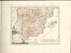

L'Espagne 1212 a 1492.
1 : 4800000 Houze, Antoine Philippe
Regnorum Hispaniae nova descriptio. [Karte], in: Theatrum orbis terrarum, sive, Atlas novus, Bd. 2, S. 192.
1 Karte aus Atlas Blaeu, Joan Blaeu, Willem Janszoon
Carte des royaumes d'Espagne et de Portugal dans laquelle sont tracées les routes des postes
1 Karte : Kupferdruck ; 47 x 56 cm Robert de Vaugondy; Haussard s.n.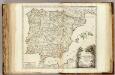
Espagne, Portugal postes.
1 : 2300000 Robert de Vaugondy, Gilles, 1688-1766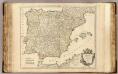
Espagne, Portugal.
1 : 2300000 Robert de Vaugondy, Gilles, 1688-1766
Hispania
1 : 2610000 Portugalsko Delisle, Guillaume Mendes Silva, Rodrigo sumptibus Matth. Seutteri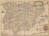
Typus Hispaniae ab Hesselo Gerardo delineata [...] [Karte], in: Novus atlas absolutissimus, Bd. 6, S. 15.
1 Karte aus Atlas Janssonius Offizin
Království španělské
Portugalsko tisk a sklad Hynka Fuchse
Hispaniæ antiquæ tabula geographica
1 Karte : Kupferdruck ; 23 x 27 cm Delamarche; Delahaye s.n.
Typus Hispaniae [Karte], in: Gerardi Mercatoris et I. Hondii Newer Atlas, oder, Grosses Weltbuch, Bd. 2, S. 168.
1 Karte aus Atlas Mercator, Gerhard und Hondius, Jodocus Jansson, Jan
Spanien und Portugal
Schul-Atlas über alle Theile der Erde nach dem neuesten Zustande, und über das Weltgebäude Stieler, Adolf bei Justus Perthes
Mapa general de Espana, dividido en sus actuales provincias, islas adyacentes, y reyno de Portugal
1 : 1400000 compuesto con lo mejor que hay impreso, manuscrito noticias de sus naturales, y sujeto á las observaciones Astronomicas por Tomas Lopez Madrid : [Tomas Lopez]

Spanien und Portugal
1 : 1500000 Kanárské ostrovy Vogel, Carl Koffmahn, Otto Justus Perthes
Mapa geológico de Espana y Portugal
1 : 2000000 Portugalsko Botella y de Hornos, Federico de Coello, Francisco
Spanien und Portugal
1 : 2300000 entworfen und gezeichnet von C. F. Weiland L.G. Jaeger sc. Weimar : Verlag des Geograph. Instituts
Regnorum Hispaniae nova descriptio. [Karte], in: Novus Atlas, das ist, Weltbeschreibung, Bd. 2, S. 196.
1 Karte aus Atlas Blaeu, Joan Blaeu, Willem Janszoon
Spanien und Portugal
Stieler's Hand-Atlas Stieler, Adolf bei Justus Perthes