Maps of Spain

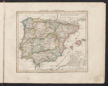
Spanien und Portugal
Schul-Atlas über alle Theile der Erde nach dem neuesten Zustande, und über das Weltgebäude Stieler, Adolf bei Justus Perthes
Spanien und Portugal
Stieler's Hand-Atlas Stieler, Adolf bei Justus Perthes
Spanjen en Portúgal
1 : 6000000 [S.l. : s.n.]
Mapa general de España
1 Karte : Kupferdruck ; 48 x 58 cm López Tomás López
Espagne, Portugal.
1 : 3600000 Janvier, Jean
Spanien und Portugal
1 : 2300000 entworfen und gezeichnet von C. F. Weiland L.G. Jaeger sc. Weimar : Verlag des Geograph. Instituts
Spanien und Portugal
1 : 2300000 entworfen und gezeichnet von C. F. Weiland L.G. Jaeger sc. Weimar : Verlag des Geograph. Instituts
Typus Hispaniae [Karte], in: Gerardi Mercatoris et I. Hondii Newer Atlas, oder, Grosses Weltbuch, Bd. 2, S. 168.
1 Karte aus Atlas Mercator, Gerhard und Hondius, Jodocus Jansson, Jan
Hispania
1 : 2610000 Portugalsko Delisle, Guillaume Mendes Silva, Rodrigo sumptibus Matth. Seutteri
Hispaniarum Portugalliæque coronarum typus novus
1 Karte : Kupferdruck ; 48 x 59 cm Valck s.n.
Accuratissima totius regni Hispaniae Portugalliaeq[ue] tabula et typus novissimus
1 : 2370000 Portugalsko Wit, Frederick de x [officina Frederici de Witt
Království španělské
Portugalsko tisk a sklad Hynka Fuchse
L'Espagne 585 a 756.
1 : 4800000 Houze, Antoine Philippe
Spanien und Portugal
Handatlas über alle Theile der Erde und über das Weltgebäude Stieler, Adolf Justus Perthes
Spanien und Portugal

Spanien und Portugal
Hand-Atlas über alle Theile der Erde nach dem neuesten Zustande und über das Weltgebäude Stieler, Adolf bei Justus Perthes
Typus Hispaniae ab Hesselo Gerardo delineata [...] [Karte], in: Novus atlas absolutissimus, Bd. 6, S. 15.
1 Karte aus Atlas Janssonius Offizin
Carte des royaumes d'Espagne et de Portugal
1 Karte : Kupferdruck ; 48 x 56 cm Robert de Vaugondy; Delamarche chez le Sr. Delamarche géographe rue du Foin St. Jacques au collége de M.e Gervais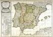
Carte des royaumes d'Espagne et de Portugal
1 Karte : Kupferdruck ; 48 x 56 cm Robert de Vaugondy; Fortin chés Fortin ingénieur mécanicien du roi pour les globes et sphères rue de la Harpe près celle du Foin
Spanien und Portugal
1 : 2260000 entworfen und gezeichnet von C. F. Weiland Weimar : Verlag des Geographischen Instituts

Spanien und Portugal
1 Karte : Kupferdruck ; 25 x 29 cm Sotzmann; Ramberg s.n.
Regnorum Hispaniæ et Portvgalliæ tabula generalis
1 Karte : Kupferdruck ; 45 x 57 cm Güssefeld; López chez les Heret. de Homann
Regnorum Hispaniæ et Portvgalliæ tabula generalis
1 Karte : Kupferdruck ; 45 x 57 cm Güssefeld; López chez les Heret. de Homann
Regnorum Hispaniae nova descriptio. [Karte], in: Theatrum orbis terrarum, sive, Atlas novus, Bd. 2, S. 192.
1 Karte aus Atlas Blaeu, Joan Blaeu, Willem Janszoon
Regnorum Hispaniae nova descriptio. [Karte], in: Novus Atlas, das ist, Weltbeschreibung, Bd. 2, S. 196.
1 Karte aus Atlas Blaeu, Joan Blaeu, Willem Janszoon
Spanien, Portugal.
1 : 4900000 Haller von Hallerstein, Friedrich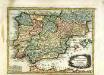
L'Espagne
1 Karte : Kupferdruck ; 19 x 25 cm Crépy chez Crepy
Weg-wyzer der legertogten in Spanje en Portugaal
1 Karte : Kupferdruck ; 49 x 57 cm Allard Abraham Allard
Accuratissima totius regni Hispaniæ Portugalliæ[que] tabula et typus novissimus
1 Karte : Kupferdruck ; 48 x 57 cm Wit ex officina Frederici de Witt
Novissima regnorum Hispaniæ et Portugalliæ tabula
1 Karte : Kupferdruck ; 48 x 56 cm Homann; Funck edita per Davidem Funcken
Hispaniae et Portugalliae regna [et]c
1 Karte : Kupferdruck ; 48 x 56 cm Homann; Funck ex officina Davidis Funckii
Hispaniæ et Portugalliæ regna
1 Karte : Kupferdruck ; 45 x 55 cm Visscher s.n.
Accuratissima totius regni Hispaniæ tabula
1 Karte : Kupferdruck ; 48 x 56 cm Danckerts ex officina Justi Danckerts