Maps of Spain

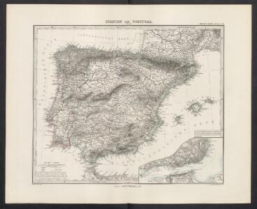
Spanien und Portugal
Handatlas über alle Theile der Erde und über das Weltgebäude Stieler, Adolf Justus Perthes
Spanien und Portugal
Adolf Stieler's Handatlas über alle Theile der Erde und über das Weltgebäude Stieler, Adolf Justus Perthes
Spanien und Portugal
Hand-Atlas über alle Theile der Erde nach dem neuesten Zustande und über das Weltgebäude Stieler, Adolf bei Justus Perthes
Hispania augustiniana
1 Karte : Kupferdruck ; 48 x 55 cm Lotter; Höggmayr; Seutter anjezo im Verlag beÿ Tob: Conr: Lotter
Spanien und Portugal
Hand-Atlas über alle Theile der Erde nach dem neuesten Zustande und über das Weltgebäude Stieler, Adolf bei Justus Perthes
Španiely a Portugaly.

Spanien und Portugal
Hand-Atlas über alle Theile der Erde und über das Weltgebäude Stieler, Adolf Justus Perthes
Španiely a Portugaly.

Charte von Spanien und Portugal : mit der neuen Eintheilung
1 : 2000000 neu gezeichnet [...] von Christoph Fembo Nürnberg : Fembo
Spanien und Portugal
Allgemeiner Atlas [Walch, Johannes] im Verlag bei Johannes Walch
Regnorum Hispaniae nova descriptio. [Karte], in: Novus Atlas, das ist, Weltbeschreibung, Bd. 2, S. 196.
1 Karte aus Atlas Blaeu, Joan Blaeu, Willem Janszoon
Regnorum Hispaniae nova descriptio. [Karte], in: Le théâtre du monde, ou, Nouvel atlas contenant les chartes et descriptions de tous les païs de la terre, Bd. 2, S. 189.
1 Karte aus Atlas Blaeu, Willem Janszoon und Blaeu, Joan Blaeu, Willem Janszoon
Regnorum Hispaniae nova descriptio. [Karte], in: Theatrum orbis terrarum, sive, Atlas novus, Bd. 2, S. 192.
1 Karte aus Atlas Blaeu, Joan Blaeu, Willem Janszoon
Mapa general de España
1 Karte : Kupferdruck ; 48 x 58 cm López Tomás López
The kingdoms of Spain & Portugal / compiled & reduced from numerous topographic surveys, the maritime survey of Don Vicente Tofino &c. ; London, publishd 1st Janury 1826 by Richard H. Laurie
1 Mapa, col. Ed. anglesa basada en obra de Tofiño Laurie, Richard H. Richard H. Laurie
Mapa general de España antigua
1 Karte : Kupferdruck ; 33 x 38 cm López se hallarà con todàs las obras del autor y las de su padre
Hispania
1 : 2610000 Portugalsko Delisle, Guillaume Mendes Silva, Rodrigo sumptibus Matth. Seutteri
Spanjen en Portúgal
1 : 6000000 [S.l. : s.n.]
Spanien und Portugal
1 : 2260000 entworfen und gezeichnet von C. F. Weiland Weimar : Verlag des Geographischen Instituts
Carte des royaumes d'Espagne et de Portugal dans laquelle sont tracées les routes des postes
1 Karte : Kupferdruck ; 47 x 56 cm Robert de Vaugondy; Haussard s.n.
L'Espagne
1 : 2600000 Aragonie (Španělsko) Sanson, Guillaume Cordier, Louis chez H. Jaillot
Typus Hispaniae [Karte], in: Gerardi Mercatoris et I. Hondii Newer Atlas, oder, Grosses Weltbuch, Bd. 2, S. 168.
1 Karte aus Atlas Mercator, Gerhard und Hondius, Jodocus Jansson, Jan
Espana y Portugal
1 : 1640000 Portugalsko López, Tomas Mauricio Tomas Mauricio Lopez
Hispaniæ antiquæ tabula geographica
1 Karte : Kupferdruck ; 23 x 27 cm Delamarche; Delahaye s.n.
Spain, Portugal.
1 : 1950000 Thomson, John
Hispaniae Et Portugalliae Regna [Karte], in: Novus atlas absolutissimus, Bd. 6, S. 18.
1 Karte aus Atlas Janssonius Offizin

Le royaume d'Espagne
1 Karte : Kupferdruck ; 50 x 64 cm Crépy chez Crepy rue St. Jacques à St. Jacques
L'Espagne
1 Karte auf 2 Blatt : Kupferdruck ; 57 x 87 cm Sanson; Denis; Basset; Basset chés Basset rüe St. Jacques au coin de celle des Mathurins à l'image Ste. Genevieve