Maps of Spain

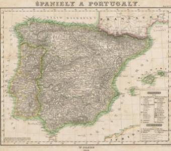
Španiely a Portugaly.

Španiely a Portugaly.

Spanien und Portugal
Adolf Stieler's Handatlas über alle Theile der Erde und über das Weltgebäude Stieler, Adolf Justus Perthes
Spanien und Portugal
Hand-Atlas über alle Theile der Erde nach dem neuesten Zustande und über das Weltgebäude Stieler, Adolf bei Justus Perthes
Mapa general de España antigua
1 Karte : Kupferdruck ; 33 x 38 cm López se hallarà con todàs las obras del autor y las de su padre
Hispania augustiniana
1 Karte : Kupferdruck ; 48 x 55 cm Lotter; Höggmayr; Seutter anjezo im Verlag beÿ Tob: Conr: Lotter
Spanien und Portugal
Handatlas über alle Theile der Erde und über das Weltgebäude Stieler, Adolf Justus Perthes
Spanien und Portugal
Hand-Atlas über alle Theile der Erde nach dem neuesten Zustande und über das Weltgebäude Stieler, Adolf bei Justus Perthes
Spanien und Portugal
Hand-Atlas über alle Theile der Erde und über das Weltgebäude Stieler, Adolf Justus Perthes
Spanien und Portugal
Allgemeiner Atlas [Walch, Johannes] im Verlag bei Johannes Walch
Regnorum Hispaniae nova descriptio. [Karte], in: Le théâtre du monde, ou, Nouvel atlas contenant les chartes et descriptions de tous les païs de la terre, Bd. 2, S. 189.
1 Karte aus Atlas Blaeu, Willem Janszoon und Blaeu, Joan Blaeu, Willem Janszoon
L'Espagne
1 Karte auf 2 Blatt : Kupferdruck ; 57 x 87 cm Sanson; Denis; Basset; Basset chés Basset rüe St. Jacques au coin de celle des Mathurins à l'image Ste. Genevieve
Charte von Spanien und Portugal : mit der neuen Eintheilung
1 : 2000000 neu gezeichnet [...] von Christoph Fembo Nürnberg : Fembo
Regnorum Hispaniae nova descriptio. [Karte], in: Novus Atlas, das ist, Weltbeschreibung, Bd. 2, S. 196.
1 Karte aus Atlas Blaeu, Joan Blaeu, Willem Janszoon
Spain, Portugal.
1 : 1950000 Thomson, John
A new and accurate map of Spain and Portugal
1 Karte : Kupferdruck ; 34 x 42 cm Bowen s.n.
Mapa general de España Antiqua, dividido en tres partes, Bética, Lusitánia y Tarraconénse, con la subdivision de cada una
1 : 3700000 por [...] Juan Lopez, pensionista de S.M [...] Madrid : [Thomas Lopez]
The kingdoms of Spain & Portugal / compiled & reduced from numerous topographic surveys, the maritime survey of Don Vicente Tofino &c. ; London, publishd 1st Janury 1826 by Richard H. Laurie
1 Mapa, col. Ed. anglesa basada en obra de Tofiño Laurie, Richard H. Richard H. Laurie
Regnorum Hispaniae nova descriptio. [Karte], in: Theatrum orbis terrarum, sive, Atlas novus, Bd. 2, S. 192.
1 Karte aus Atlas Blaeu, Joan Blaeu, Willem Janszoon
Hispania
1 : 2610000 Portugalsko Delisle, Guillaume Mendes Silva, Rodrigo sumptibus Matth. Seutteri
Mapa general de España
1 Karte : Kupferdruck ; 48 x 58 cm López Tomás López
Carte routière des royaumes d'Espagne et de Portugal
1 Karte auf 2 Blatt : Kupferdruck ; 57 x 87 cm Jaillot; Longchamps; Basset; López; Basset chez Basset rue St. Jacques au coin de celle des Mathurins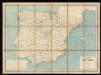
Carta itineraria de España
1 : 1500000 Depósito Central de Planos de la Dirección General de Obras Públicas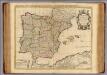
L'Espagne.
1 : 2600000 Mendez Sylva, Rodrigo
L'Espagne.
1 : 2600000 Mendez Sylva, Rodrigo
Spanjen en Portúgal
1 : 6000000 [S.l. : s.n.]
Carte des royaumes d'Espagne et de Portugal dans laquelle sont tracées les routes des postes
1 Karte : Kupferdruck ; 47 x 56 cm Robert de Vaugondy; Haussard s.n.
Regnorum Hispaniæ et Portugalliæ tabula generalis
1 Karte : Kupferdruck ; 47 x 55 cm Homann Johann Baptist Homann