Maps of Spain
Espagne, Portugal postes.
1 : 2300000 Robert de Vaugondy, Gilles, 1688-1766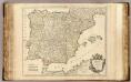
Espagne, Portugal.
1 : 2300000 Robert de Vaugondy, Gilles, 1688-1766
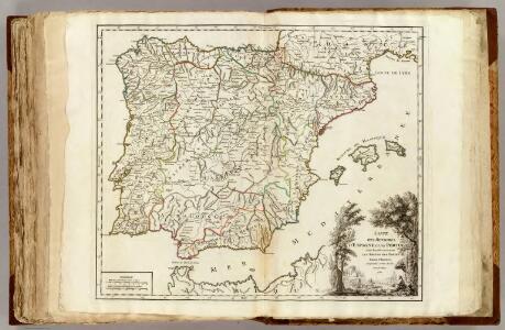
Carte des royaumes d'Espagne et de Portugal dans laquelle sont tracées les routes des postes
1 Karte : Kupferdruck ; 47 x 56 cm Robert de Vaugondy; Haussard s.n.

Espana y Portugal
1 : 1640000 Portugalsko López, Tomas Mauricio Tomas Mauricio Lopez
Hispaniæ antiquæ tabula geographica
1 Karte : Kupferdruck ; 23 x 27 cm Delamarche; Delahaye s.n.
Hispania
1 : 2610000 Portugalsko Delisle, Guillaume Mendes Silva, Rodrigo sumptibus Matth. Seutteri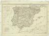
Die Königreiche Spanien und Portugal nach den neuesten Beobachtungen verfasst
1 : 2220000 Portugalsko Tranquillo Mollo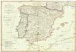
Die Königreiche Spanien und Portugal
1 : 2200000 Portugalsko Mollo, Tranquillo Tranquillo Mollo
Hispania augustiniana
1 Karte : Kupferdruck ; 48 x 55 cm Lotter; Höggmayr; Seutter anjezo im Verlag beÿ Tob: Conr: Lotter
Spanien und Portugal
Plastischer Schul-Atlas über alle Theile der Erde : in 24 Karten Woldermann, G Verlag von P. Eckerlein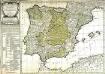
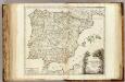
Carte des royaumes d'Espagne et de Portugal
1 Karte : Kupferdruck ; 48 x 56 cm Robert de Vaugondy; Delamarche chez le Sr. Delamarche géographe rue du Foin St. Jacques au collége de M.e Gervais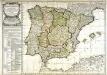
Carte des royaumes d'Espagne et de Portugal
1 Karte : Kupferdruck ; 48 x 56 cm Robert de Vaugondy; Fortin chés Fortin ingénieur mécanicien du roi pour les globes et sphères rue de la Harpe près celle du Foin
Spanien und Portugal
Neuer Handatlas über alle Theile der Erde Kiepert, Heinrich Verlag von Dietrich Reimer
Spanien und Portugal
Hand-Atlas über alle Theile der Erde und über das Weltgebäude Stieler, Adolf Justus Perthes
70-71. Spain and Portugal. The World Atlas.
1 : 2500000 USSR (Union of Soviet Socialist Republics).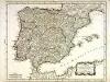
Carte du royaume d'Espagne et de Portugal
1 Karte : Kupferdruck ; 33 x 42 cm Bourgoin chez Bourgoin graveur rue de la Harpe vis a vis le passage des Jacobins a coté du Caffé de Condé
Spanien und Portugal
Hand-Atlas über alle Theile der Erde nach dem neuesten Zustande und über das Weltgebäude Stieler, Adolf bei Justus Perthes
Spanien und Portugal
Adolf Stieler's Handatlas über alle Theile der Erde und über das Weltgebäude Stieler, Adolf Justus Perthes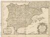
L'Espagne
1 : 2600000 Aragonie (Španělsko) Sanson, Guillaume Cordier, Louis chez H. Jaillot
Composite: Carte de la Peninsule Hispanique.
1 : 2750000 Vivien de St Martin, L.

Charte von Spanien und Portugal : mit der neuen Eintheilung
1 : 2000000 neu gezeichnet [...] von Christoph Fembo Nürnberg : Fembo
Spanien und Portugal
Hand-Atlas über alle Theile der Erde nach dem neuesten Zustande und über das Weltgebäude Stieler, Adolf bei Justus Perthes
Postkarte von Spanien und Portugal
Portugalsko Engelmann, Johann Wenzel im von Reillyschen Landkarten und Kunstwerke Verschleiss Komptoir
L'Espagne 585 a 756.
1 : 4800000 Houze, Antoine Philippe
Spanien und Portugal
1 : 2260000 entworfen und gezeichnet von C. F. Weiland Weimar : Verlag des Geographischen Instituts
Carte des routes de postes et itinéraires d'Espagne et de Portugal
1 : 2500000 par Ch. Picquet dressée par Lapie, Ingr. géographe, d'après les cartes de Lopez, Tofino et autres documents authentiques. Paris : chez Ch. Picquet
Los reynos de Espan̂a y Portugal
1 Karte : Kupferdruck ; 46 x 54 cm s.n.