Maps of Unhošť

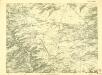
Mapa bývalého dekanátu [sic] Ořechovského
Ořech (Česko) Schmidt, Eduard Winkler, Johann Christoph
Belagerung der Königl. Haupt-Stadt Prag
1 : 57000 Berounka (Česko) Werner, Bedřich Bernard Strahowsky, B.
Soubor map okresů Pražského kraje

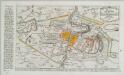
Mapa okresu smíchovského v Pražském kraji = Karte des Smichower Bezirkes im Prager Kreise : podle nejnovějších a nejbezpečnějších pramenů sestavena a vydána k založení obecních knihoven ve veškerých okresích kraje Pražského

III. vojenské mapování 3952/4
1 : 25000
Gradkartenblatt
1 : 25000 Unhošť-oblast (Česko) Albrecht, Julius
Bez titulu: Čechy – kolekce vedut
III. vojenské mapování 3952/4
1 : 25000
[Praha a okolí]
Praha-oblast (Česko)
Belagerung der königlicher Haupt-Stadt Prag...

Plan der Battaille welche d. 6. Maj zwischen den Kayserl. Königl. Ungarische[n] u. Königlich Preusische[n] Armee bey Prag geliefert worden. 1757
1 : 90000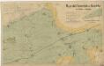
Mapa okolí Svárovského a Nučického mezi Prahou a Berounem

Ideal-Plan uiber den in VI Theilen zur Verpachtung angetragenen k.k. Jagd-Reserval-Bezirk
Braník (Praha, Česko)
Okolí města Prahy na hodinu cesty
Praha-oblast (Česko) K. Hübner
Plan der Hauptstadt Prag und der umliegenden Gegend sammt dem Lustlager der kais. königl. Armée
1 : 47500 Praha (Česko)
Plan der Hauptstadt Prag und der umliegenden Gegend sammt dem Lustlager der kais. königl. Armée
1 : 47500 Praha (Česko)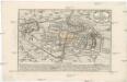
Plan der Battaille welche d. 6. Maj zwischen der kayserlich-königlich-ungarischen und königlich preussischen Armée bey Prag geliefert worden, 1757
Praha (Česko)

Karte des Smichower Bezirkes im Prager Kreise
1 : 70000 Praha-oblast (Česko) Wagner, Jan Eduard Karl André
Verbesserter Grundriß der königl. bohmischen Haupt Stadt Prag mit der königl. ungarschen Belagerung und Attaquen A 1742
Praha (Česko) Riegel, Christoph bey Christoph Riegel
Grundriß der königl. bohmischen Haupt Stadt Prag mit der königl ungarschen Belagerung und Attaquen A 1742
Praha (Česko)
Prag's Umgebungen
Praha-oblast (Česko) Scheiner, Josef Kettner, C. J.G. Calve'sche Buchhandlung
Prag und seine Umgebungen, nach den besten Hülfsmitteln dargestellt
1 : 42000 C. Kettner sculp. Prag : J. G. Calve'sche Buchhandlung
[Belagerung von Prag]
1 : 48000 Praha-oblast (Česko) Brequin, Jean-Baptiste
Grundriss der König. Bohmischen Haupt Stadt Prag
Praha (Česko) Christoph Riegel Buchhändlen
Specielle Telegrafen und Eisenbahn Karte von Böhmen
Jižní Město. - Háje Orientační plán 1. souboru
1 : 3500
Jižní Město. - Litochleby Orientační plán 3. souboru
1 : 2500
![Mapa bývalého dekanátu [sic] Ořechovského](https://images-2.georeferencer.com/images/iiif/948747734997/full/,300/0/native.jpg)

