Maps of Grand Est
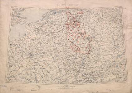
Territory in Western Germany occupied by the Allied Armies
1 : 1000000 First World War map of the territory in Western Germany occupied by the Allied Armies and the stages of evacuation according to article 429 of the peace treaty. Situation for July 1921. War Office
Birds eye view of the seat of War in Europe
1 : 1
Belli ab obitu Caroli VI. Imperatoris usqve ad pacem Dresdae d. 25. Dec. MDCCXLV
1 : 1300000 Mollova mapová sbírka Kraus, Lorenz Jacob Homann, Johann Baptista - dědici
Belgica oder Nieder Teutschland
Belgie Baumgarten, Siegmund Jakob Johann Justinus Gebauer
Carte des principaux points du théatre de la guerre présente sur le frontieres d'Allemagne et de Pays-Bas
1 : 2200000 Francie Bouge, Jean-Baptiste de chez J. B. de Bouge
Frankreich. Upper right sheet
1 : 1200000 Geographisches Institut (Weimar, Germany)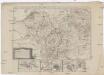
Neue Karte von den gegenwärtigen Französischen Kriegs - Schauplatze, welche die Länder am Ober und nieder Rhein, Elßas, Lothringen, die Nieder-Pfaltz, Maynz, Trier, Cöln, dei Österreichische Niederlandes, ein Theil von Frankreich, Westphalen, Heßsen und Schwaben etc
1 : 1400000 Alsasko (Francie)
Carte de la France, 2
2 Blätter : mehrfarbig ; 71 x 83 cm de Belleyme
Neueste und aceurate Landkarte des volligen-Rheinstroms mit den daran gelegenen Landschafften und benachbarten Provinzien, auch einem grossen theil des Franzos: Konigreiches
Mollova mapová sbírka Lerch, Johann Martin Lerch, Johann Martin
France.
1 : 4400000 Vivien de St Martin, L.
Le Rhin
1 : 1600000 Dubail, Edmond 1851-1934 Paris : imp. Monrocq
[Frankreich, Blatt 2]
Adolf Stieler's Handatlas über alle Theile der Erde und über das Weltgebäude Stieler, Adolf Justus Perthes
Skizze zur Orientirung ϋber den Feldzug 1795
Germania Parte Occidentale
1 : 2100000 Mollova mapová sbírka Coronelli, Vincenzo Maria
Germania Parte Occidentale
1 : 2100000 Mollova mapová sbírka Coronelli, Vincenzo Maria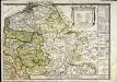
Le royaume de France orientale, dit autrement Austrasie
1 Karte : Kupferdruck ; 39 x 49 cm, Bildgrösse 39 x 56 cm Duval chez l'auteur en l'isle du Palais sur le quay de l'Orloge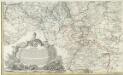
Kriegs Expeditions Karte von Devtschland
1 : 1700000 Mollova mapová sbírka Rizzi Zannoni, Giovanni Antonio Homann, Johann Baptista - dědici
Carte des peuples riverains du Rhin au temps d’Auguste et de ses successeurs immédiats
Mitteleuropa Rhein-Gebiet ethnische Gruppe Germanen
Unsere Westgrenze
1 : 1000000 Evropa západní Velhagen & Klasing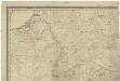
[Západní Evropa]
Belgie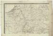
[Západní Evropa]
Belgie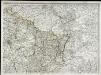
Carte de la France, 2
1 Blatt : 61 x 83 cm de Belleyme
France frontiére Nord-Est et alsace-lorraine
Vidal de La Blache, Paul
Carte de la République française, 2
1 Blatt : 42 x 51 cm P.G. Chanlaire
[Frankreich in 4 Blättern, Nordöstliches Frankreich]
Hand-Atlas über alle Theile der Erde und über das Weltgebäude Stieler, Adolf Justus Perthes
F. Handtke's Special-Karte vom Deutsch-Franz. Kriegsschauplatze
1 : 600000 Belgie Handtke, Friedrich C. Flemming
Schauplatz des dermahligen Krieges, 1793
1 : 2775000 Belgie Stöber, Joseph
67-68. North-East France, Belgium, Luxemburg. The World Atlas.
1 : 1250000 USSR (Union of Soviet Socialist Republics).
Nordost-Frankreich und Belgien
1 : 750000 Belgie Justus Perthes