Maps of Germany
Le Rhin
1 : 1600000 Dubail, Edmond 1851-1934 Paris : imp. Monrocq
Central Europe.
1 : 2000000 Hughes, William
Der Deutsch-französische Kriegsschauplatz
1 : 900000 Evropa severozápadní König, Gustav Moriz Perles
[Západní Evropa]
Belgie
[Západní Evropa]
Belgie
Birds eye view of the seat of War in Europe
1 : 1
Charte von Deutschland zu dem Meilen-Zeiger
1 : 222000 Německo Schreiber, Johann Georg
Germaniae, Galliae & Rhaetiae pars
1 : 2850000 Galie Heimburger, August Bibliographisches Institut
Belli ab obitu Caroli VI. Imperatoris usqve ad pacem Dresdae d. 25. Dec. MDCCXLV
1 : 1300000 Mollova mapová sbírka Kraus, Lorenz Jacob Homann, Johann Baptista - dědici
Carte von Ober u. Nieder Teutschland
1 : 4500000 Mollova mapová sbírka Vogel
West Deutschland und Ost Frankreich, Niederlande und Belgien
1 : 2000000 Belgie Kozenn, B. Hölzel, Eduard Ed. Hölzel
Neue Karte von den gegenwärtigen Französischen Kriegs - Schauplatze, welche die Länder am Ober und nieder Rhein, Elßas, Lothringen, die Nieder-Pfaltz, Maynz, Trier, Cöln, dei Österreichische Niederlandes, ein Theil von Frankreich, Westphalen, Heßsen und Schwaben etc
1 : 1400000 Alsasko (Francie)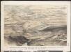
Stannard & Son's, panoramic birds-eye view of the French & Prussian provinces, on the banks of the Rhine, shewing all the fortresses belonging to each army, with the railways & frontier boundaries of each country
1 : 1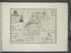
A new map of the Netherlands or Low Countries, shewing their principal divisions, cities, towns, rivers &c.
from A new sett of maps both of antient and present geography : wherein not only the latitude and longitude of many places are corrected according to the latest observations, but also the most remarkable differences of antient and present geography may be quickly discern'd by a bare inspection or comparing of correspondent maps, which seems to be the most natural and easy method to lead young students (for whose use the work is principally intended) unto a competent knowledge of the geographical science : together with a geographical treatise particularly adapted to the use and design of these maps / by Edward Wells, M.A. and student of Christ-Church, Oxon.
Skizze zur Orientirung ϋber den Feldzug 1795
Territory in Western Germany occupied by the Allied Armies
1 : 1000000 First World War map of the territory in Western Germany occupied by the Allied Armies and the stages of evacuation according to article 429 of the peace treaty. Situation for July 1921. War Office
Carte itineraire de l'empire d'Allemagne et des frontieres
1 : 2140000 Německo
Royaume des Pays-Bas. Europe 13.
1 : 1641836 Vandermaelen, Philippe, 1795-1869
Carte des peuples riverains du Rhin au temps d’Auguste et de ses successeurs immédiats
Mitteleuropa Rhein-Gebiet ethnische Gruppe Germanen
Bibliopolische Karte von Süddeutschland
Frankfurt nad Mohanem (Německo)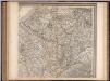
Frankreich. Upper right sheet
1 : 1200000 Geographisches Institut (Weimar, Germany)
Germany No.4.
1 : 1375000 Colton, G.W.
Soubor map

Kaart van de Nederlandsche Noorder- en Zuider spoorwegen
1 : 2000000 [S.l.] : [s.n.]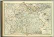
Empire of Germany (southern portion).
1 : 1050000 Johnston, W. & A.K.
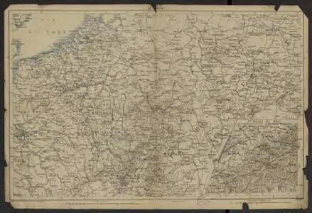
Bojište [sic] 1870
Belgie Bedřich Sandtner
Tabula generalis totius Belgii
1 : 1000000 Belgie Homann, Johann Baptist á Iohanne Baptista Homanno
TABULA GENERALIS TOTIUS BELGII qua PROVINCIAE XVII. INFER. GERMANIAE olim sub S.R.I. CIRCULO BURGUNDIAE
1 : 1100000 Belgie Homann, Johann Baptist â Iohanne Baptista Homanno
Tabula generalis totius Belgii
1 : 1000000 Belgie Homann, Johann Baptist á Iohanne Baptista Homanno