Maps of Plymouth
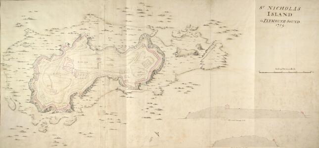
A coloured plan of St. Nicholas' Island in Plymouth Sound
Birds eye view of St Nicholas Island in Plymouth Sound. The island is the principal guide for ships entering the dock. It is said that when he was a child Sir Francis Drake was sent here by his parents for protection at a time of civil disturbance. In the 18th century the island was renamed Drake’s Island in his memory but until the mid 19th century it was still referred to as St Nicholas Island. The fortification on the island was built in the 16th century and became the principal defences for Plymouth sound. In the 19th century the fortification was greatly enlarged and extra gun batteries were added.
Devonshire CXXIII.SE - OS Six-Inch Map
1 : 10560 Topographic maps Ordnance Survey Ordnance Survey
A chart of Plymouth Sound, with "il novo recinto della fortificatione de la ville de Pleymouth;"
This is a plan of the area around Plymouth Sound. It is orientated to the south with Penlee point to the south west and Bovisand Bay south east. It dates from 1601-1602 and may show the proposals of the Italian engineer Frederico Genibelli. Genibelli had been sent by the Privy Council in response to requests by the governor of the fort, Sir John Gilbert, that defects in the fortifications be repaired. Plymouth Sound is situated in such a way as to make it an ideal invasion target as although geographically far from heart of national government Plymouth was accessible to the outside world, especially France and Spain and provided access to centre of the country. This plan illustrates the position occupied by the fort in relation both to the town and to its surrounding countryside, although the latter is inaccurately portrayed out of scale. The town of Plymouth is surrounded by a perimeter wall. Beacons are shown at Staddon, Maker and Penlee, highlighting the measures in place to raise the alarm in case of invasion. When surveying the deficiencies in the defences of the fort and island, Genibelli outlined a new scheme for fortifying the town with nine ravelins at a cost of £3000. These are outworks which consist of two faces which form a salient angle. The proposed scheme is clearly shown here but was not carried out by the government. Genibelli, Frederico
Devonshire CXXIII - OS Six-Inch Map
1 : 10560 Topographic maps Ordnance Survey Ordnance Survey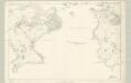
Cornwall LV - OS Six-Inch Map
1 : 10560 Topographic maps Ordnance Survey Ordnance Survey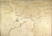
General Plan of the Ports of Homouse and Plymouth
Plan of the Ports of Hamoaze and Plymouth in Devon. This is the point where the rivers Tamar, Tavy and Lynher enter Plymouth Sound. Proposals for a dockyard at Hamoaze were first proposed by Sir Francis Drake in the late 16th century. It was felt that the broad estuary here afforded excellent natural protection however it was not until 1690 that work began here. William III appointed Edmund Dummer, surveyor to the Royal Navy, to build the dock and it became known as Plymouth Dock. By the 19th century Plymouth Dock was actually bigger than Plymouth itself and in 1824 it became independent, the town and the dockyard becoming known as Davenport. This is now the largest naval base in Western Europe.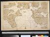
Nieuwe afteekeningh van de haven van Plijmouth geleegen int Canaal aen de kust van Engeland
England Gerard van Keulen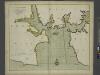
A new and correct large draught PLYMOUTH SOUND catt-water and ham-owse
from The sea-atlas : containing an hydrographical description of most of the sea-coasts of the known parts of the world.
To the Right Honorable the Master, Wardens & Elder Brethren of the Trinity House, this Chart of Plymouth Sound is ... dedicated
1 : 26000 Heather, W. (William) Heather, W. (William)
A coloured scheme for fortifying the island of St Nicholas, or Drake's Island, in Plymouth Sound
Plan of Plymouth harbour with particular attention to St Nicholas Island thought to have been drawn by a French or Dutch artist. It is said that when he was a child, Sir Francis Drake was sent here by his parents for protection at a time of civil disturbance. In the 18th century the island was renamed Drake’s Island in his memory but until the mid 19th century it was still referred to as St Nicholas Island. The island was first fortified in the 17th century and was important because it was situated in the centre of Plymouth Sound and protected the approaches to the harbours and the estuaries of the rivers Tamar and Plym.
The environs of Plymouth, Devonport and Stonehouse : also the neighborhood of Exeter with the coast and other principal roads [...]
1 : 65000 engraved [...] by John Cooke Stonehouse : sold by John Cooke
Plan of Plymouth harbour
Located in the south western peninsula of England, Plymouth Harbour commands the western approaches to the island and by the 16th century had become the country’s most important naval seaport. This plan depicts the harbour of Plymouth, as it was in the late 17th century, from St. Germains on the west to Saltram on the east.
A coloured chart of Plymouth Harbour, and of the country up to Tavistock; drawn possibly by Robert Spry
This is a map of Plymouth and environs and is a 16th century copy of an original map dating from 1591 by Robert Spry. Spry is recorded as a painter in municipal records between 1569-70 and 1591-2. The map is drawn in a somewhat archaic pictorial style with topographical details drawn in perspective. Great detail has been observed in the depiction of churches and country houses and three beacons, the means of alerting the surrounding area, are recorded. The anchorages of the Sound are marked by drawings of ships. The map shows the conduit or leat that was constructed by Sir Francis Drake in 1590-1 in order to provide a water-supply for the town from Dartmoor. In connection with his leat, Drake had been granted a lease of the six town mills in 1583. The leat was designed for the watering of ships and to power the mills and played a central role in Drake’s hopeful project to make Plymouth a powerful naval station. Although popular local tradition suggested that Drake had employed magic in order to effect the construction of the leat which passed through "mighti rockes which was thought unpossible to carrie water through", it was in fact the work of the Plymouth engineers Robert Lampen and his brother. Figures along the course of the leat, from the River Meavy to Plymouth record miles. A section that is likely to have contained an explanatory table has been removed, resulting in the maps irregular shape. Spry, Robert
Plymouth (Hills) - OS One-Inch Revised New Series
1 : 63360 Topographic maps Ordnance Survey Ordnance Survey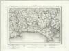
Plymouth (Outline) - OS One-Inch Revised New Series
1 : 63360 Topographic maps Ordnance Survey Ordnance Survey
Plymouth - OS One-Inch Map
1 : 63360 Topographic maps Ordnance Survey Ordnance Survey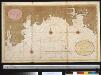
Een gedeelte van het Kanaal vant eijland Bun tot de R. van Vaalmouth
England Gerard van Keulen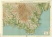
South Devon, Sheet 36 - Bartholomew's "Half Inch to the Mile Maps" of England & Wales
1 : 126720 Topographic maps Bartholomew, John George John Bartholomew & Co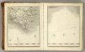
Sheets 3-4. (Cary's England, Wales, and Scotland).
1 : 360000 Cary, John, ca. 1754-1835
Devonshire
1 : 640000 Devon (Anglie) Hall, Sid. by Chapman & Hall
Devoniae descriptio = The description of Devon-Shire
1 : 180000 Amstelodami : apud Joannem Janssonium
DEVONIAE COMITAT
This map of Devon is from the 1583 edition of the Saxton atlas of England and Wales. This atlas was first published as a whole in 1579. It consists of 35 coloured maps depicting the counties of England and Wales. The atlas is of great significance to British cartography as it set a standard of cartographic representation in Britain and the maps remained the basis for English county mapping, with few exceptions, until after 1750. During the reign of Elizabeth I map use became more common, with many government matters referring to increasingly accurate maps with consistent scales and symbols, made possible by advances in surveying techniques. Illustrating the increasing used of maps in government matters, Lord Burghley, Elizabeth I’s Secretary of State, who had been determined to have England and Wales mapped in detail from the 1550s, selected the cartographer Christopher Saxton to produce a detailed and consistent survey of the country. The financier of the project was Thomas Seckford Master of Requests at the Court of Elizabeth I, whose arms appear, along with the royal crest, on each map. The decorative scale bar houses the name of Saxton and of the Flemish engraver Remigius Hogenberg who prepared the copper plate for this map. This is the only map in the atlas that features a compass rose as well as the cardinal points in the borders, seeming to indicate the Devon has been turned slightly clockwise to fit the plate. Two ships engaging in battle are depicted off the coast of Plymouth, perhaps making reference to the vulnerability of this section of south coast and the location of naval bases. Saxton, Christopher Ryther, Augustine
DEVONIAE COMOTAT
This map of Devon is by Christopher Saxton and dates from 1575. It forms part of an atlas that belonged to William Cecil Lord Burghley, Secretary of State to Elizabeth I. Burghley used this atlas to illustrate domestic matters. This map is actually a proof copy of one which forms part of Christopher Saxton’s Atlas of England and Wales. This atlas was first published as a whole in 1579. It consists of 35 coloured maps depicting the counties of England and Wales. The atlas is of great significance to British cartography as it set a standard of cartographic representation in Britain and the maps remained the basis for English county mapping, with few exceptions, until after 1750. During the reign of Elizabeth I map use became more common, with many government matters referring to increasingly accurate maps with consistent scales and symbols, made possible by advances in surveying techniques. This map was produced under the patronage of Thomas Seckford, a Master of Requests to Elizabeth I, who had commissioned Saxton’s atlas of county maps, a project overseen by Lord Burghley, Secretary of State, whose administration increasingly involved the use of maps. This map is interesting as there are several notes in the margins. In the lower right hand margin: 'A Note of hir maties Store of Ordonnaunce, powder and match, lead,&c.,remayningin ye L. Lieutenauntes, &c. hands'. In the upper right hand margin 'A Note what powder and match was appointed to be kept in store in every corporate towne'. In the left hand margin 'A Breef Note of ye places of Descent. . . yt are most daungerous and require greatest regard and assistaunce'. These annotations were most probably made by an assistant of Lord Burghley’s, and show the concern felt about coastal areas in the face of the threat from Spain which culminated in 1588 with the events of the Spanish Armada. Saxton, Christopher Hogenbergius, Remigius
A new map of the County of Devon
London : C. Smith
Cornvbia sive Cornwallia
1 Karte : Kupferdruck ; 38 x 48 cm Blaeu Joan Blaeu
South west coast of England from Exeter to Land's End, 1539-40
This is a map of the south-west coast of England, from Exeter to Land’s End. It dates from 1539-40 and its creation can be imputed to the threat of invasion which became probable in 1538 after a peace treaty was signed by Francis I of France and Charles V, Holy Roman Emperor and King of Spain. England and France were ancient enemies and the Catholic Charles V, nephew of Catherine of Aragon, was angered by Henry VIII’s decision to divorce her. Henry’s dissolution of the monasteries provided him with enormous wealth with which he was able to commission surveys of the vulnerable coastline and build defence fortifications. This map is the result of the order sent out by Thomas Cromwell in 1539 for the coasts to be surveyed by local people. These surveys, which were often just sketches or even text, were sent to London and in Greenwich they were edited, compiled and copied out for presentation to the King, who displayed them in Whitehall. The style of the map is pictorial with details such as ships, town views and fortifications shown in accurate detail. However, it contains vital practical information such as the state of defences and the distance between points along the coast and measurements at sea. Measurements at sea appear to be the estimated distance at which the navigator could discern features of the coastline. These are given in Dutch kennings probably due to the fact that the draftsmen in Greenwich included Flemish artists. The purpose of the map was to indicates, as if from the viewpoint of an invader, where landings could be made. Therefore, the cliffs, where landings would have been impossible are foreshortened, while the sandy beaches, where landings would have been easy are exaggerated in size. The sites for possible forts were then added to the map. The annotations on this map were made in about 1541 and record the state of fortifications, annotating made’ or not made’ over several fortification and half made’ over St Mawes Castle. Although this map contains measurements for use by sailors it is very unlikely that it would ever have been used at sea as it is almost 10 feet long and thus highly impractical for use within the confined space onboard ship. Thomas Cromwell
DEVONIA | vulgo | DEVON-SHIRE.
[Amsterdam : Joan Blaeu]
Cornubia sive Cornwallia
1 : 170000 Amstelodami : excudebat Ioannes Ianssonius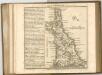

An accurate map of Devon Shire
1 Karte : Kupferdruck ; 50 x 65 cm Bowen; Tinney sold by I. Tinney at the Golden Lion in Fleet street