Maps of Maker-with-Rame

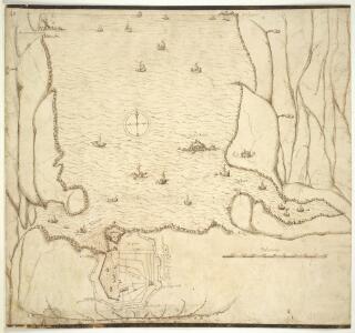
A chart of Plymouth Sound, with "il novo recinto della fortificatione de la ville de Pleymouth;"
This is a plan of the area around Plymouth Sound. It is orientated to the south with Penlee point to the south west and Bovisand Bay south east. It dates from 1601-1602 and may show the proposals of the Italian engineer Frederico Genibelli. Genibelli had been sent by the Privy Council in response to requests by the governor of the fort, Sir John Gilbert, that defects in the fortifications be repaired. Plymouth Sound is situated in such a way as to make it an ideal invasion target as although geographically far from heart of national government Plymouth was accessible to the outside world, especially France and Spain and provided access to centre of the country. This plan illustrates the position occupied by the fort in relation both to the town and to its surrounding countryside, although the latter is inaccurately portrayed out of scale. The town of Plymouth is surrounded by a perimeter wall. Beacons are shown at Staddon, Maker and Penlee, highlighting the measures in place to raise the alarm in case of invasion. When surveying the deficiencies in the defences of the fort and island, Genibelli outlined a new scheme for fortifying the town with nine ravelins at a cost of £3000. These are outworks which consist of two faces which form a salient angle. The proposed scheme is clearly shown here but was not carried out by the government. Genibelli, Frederico
Devonshire CXXIII.SE - OS Six-Inch Map
1 : 10560 Topographic maps Ordnance Survey Ordnance Survey
Insurance Plan of Plymouth Vol. 1: Key Plans 2
1 : 4800 This "key plan" indicates coverage of the Goad 1891 series of fire insurance maps of Plymouth that were originally produced to aid insurance companies in assessing fire risks. The building footprints, their use (commercial, residential, educational, etc.), the number of floors and the height of the building, as well as construction materials (and thus risk of burning) and special fire hazards (chemicals, kilns, ovens) were documented in order to estimate premiums. Names of individual businesses, property lines, and addresses were also often recorded. Together these maps provide a rich historical shapshot of the commercial activity and urban landscape of towns and cities at the time. The British Library holds a comprehensive collection of fire insurance plans produced by the London-based firm Charles E. Goad Ltd. dating back to 1885. These plans were made for most important towns and cities of the British Isles at the scales of 1:480 (1 inch to 40 feet), as well as many foreign towns at 1:600 (1 inch to 50 feet). Chas E Goad Limited Chas E Goad Limited
Devon CXXIII.11 (includes: Devonport; East Stonehouse; Maker With Rame; Plymouth) - 25 Inch Map
1 : 2500 Topographic maps Ordnance Survey Ordnance Survey
Devon CXXIII.11 (includes: Devonport; East Stonehouse; Maker With Rame; Plymouth) - 25 Inch Map
1 : 2500 Topographic maps Ordnance Survey Ordnance Survey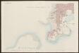
Devon CXXIII.11 (includes: Devonport; East Stonehouse; Maker With Rame; Plymouth) - 25 Inch Map
1 : 2500 Topographic maps Ordnance Survey Ordnance Survey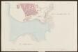
Devon CXXIII.11 (includes: Devonport; East Stonehouse; Maker With Rame; Plymouth) - 25 Inch Map
1 : 2500 Topographic maps Ordnance Survey Ordnance Survey
Devon CXXIII.11 (includes: Devonport; East Stonehouse; Maker With Rame; Plymouth) - 25 Inch Map
1 : 2500 Topographic maps Ordnance Survey Ordnance Survey
Devon CXXIII.16 & 15 (includes: Maker With Rame; Plymouth; Plymstock) - 25 Inch Map
1 : 2500 Topographic maps Ordnance Survey Ordnance Survey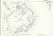
Devon CXXIII.15 (includes: Maker With Rame) - 25 Inch Map
1 : 2500 Topographic maps Ordnance Survey Ordnance Survey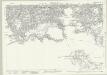
Devon CXXIII.12 (includes: East Stonehouse; Plymouth; Plymstock) - 25 Inch Map
1 : 2500 Topographic maps Ordnance Survey Ordnance Survey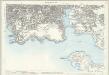
Devon CXXIII.12 (includes: East Stonehouse; Plymouth; Plymstock) - 25 Inch Map
1 : 2500 Topographic maps Ordnance Survey Ordnance Survey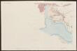
Devon CXXIII.12 (includes: East Stonehouse; Plymouth; Plymstock) - 25 Inch Map
1 : 2500 Topographic maps Ordnance Survey Ordnance Survey
Devon CXXIII.12 (includes: East Stonehouse; Plymouth; Plymstock) - 25 Inch Map
1 : 2500 Topographic maps Ordnance Survey Ordnance Survey
Devon CXXIII.7 (inset CXXIII.8 & CXXIII.12) (includes: East Stonehouse; Plymouth; Plymstock) - 25 Inch Map
1 : 2500 Topographic maps Ordnance Survey Ordnance Survey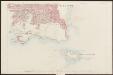
Devon CXXIII.12 (includes: East Stonehouse; Plymouth; Plymstock) - 25 Inch Map
1 : 2500 Topographic maps Ordnance Survey Ordnance Survey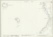
Devon CXXIII.16 & 15 (includes: Maker With Rame; Plymouth; Plymstock) - 25 Inch Map
1 : 2500 Topographic maps Ordnance Survey Ordnance Survey
Devon CXXIII.16 (includes: Plymouth; Plymstock) - 25 Inch Map
1 : 2500 Topographic maps Ordnance Survey Ordnance Survey
Devon CXXIII.16 (includes: Plymouth; Plymstock) - 25 Inch Map
1 : 2500 Topographic maps Ordnance Survey Ordnance Survey
An Exact Plan of the Royal Citadel and Town of Plymouth
A plan of the town, citadel, dock, and country round Plymouth. Located in the south western peninsula of England, Plymouth Harbour commands the western approaches to the island and by the 16th century had become the country’s most important naval seaport. The citadel was built on the Hoe- the name means high ground’ and it was the highest point in the area, in 1670. It was built in 1662 for Charles II as a fortress against the local Parliamentarians. In 1690 the first Royal Dockyard opened on the banks of the Tamar to the west of Plymouth. Further docks were built in 1727, 1762 and 1793, and a huge naval complex was later established here.
Cornwall XLVI.14 (includes: Devonport; East Stonehouse; Maker with Rame; Torpoint) - 25 Inch Map
1 : 2500 Topographic maps Ordnance Survey Ordnance Survey
Cornwall XLVI.14 (includes: Devonport; East Stonehouse; Maker with Rame; Torpoint) - 25 Inch Map
1 : 2500 Topographic maps Ordnance Survey Ordnance Survey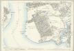
Cornwall XLVI.14 (includes: Devonport; East Stonehouse; Maker with Rame; Torpoint) - 25 Inch Map
1 : 2500 Topographic maps Ordnance Survey Ordnance Survey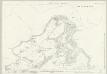
Cornwall LV.2 (includes: East Stonehouse; Maker with Rame; Millbrook) - 25 Inch Map
1 : 2500 Topographic maps Ordnance Survey Ordnance Survey
Cornwall LV.2 (includes: East Stonehouse; Maker with Rame; Millbrook) - 25 Inch Map
1 : 2500 Topographic maps Ordnance Survey Ordnance Survey
Cornwall LV.2 (includes: East Stonehouse; Maker with Rame; Millbrook) - 25 Inch Map
1 : 2500 Topographic maps Ordnance Survey Ordnance Survey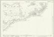
Cornwall LV.6 (includes: Maker with Rame) - 25 Inch Map
1 : 2500 Topographic maps Ordnance Survey Ordnance Survey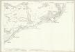
Cornwall LV.6 (includes: Maker with Rame) - 25 Inch Map
1 : 2500 Topographic maps Ordnance Survey Ordnance Survey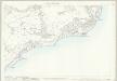
Cornwall LV.6 (includes: Maker with Rame) - 25 Inch Map
1 : 2500 Topographic maps Ordnance Survey Ordnance Survey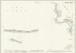
Devon CXXIX.4 & 3 (includes: Maker With Rame; Plymouth Lighthouse; Plymstock; Wembury) - 25 Inch Map
1 : 2500 Topographic maps Ordnance Survey Ordnance Survey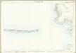
Devon CXXIX.4 (includes: Plymouth Lighthouse; Plymstock; Wembury) - 25 Inch Map
1 : 2500 Topographic maps Ordnance Survey Ordnance Survey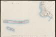
Devon CXXIX.4 (inset CXXIX.3) (includes: Plymouth Lighthouse; Plymstock; Wembury) - 25 Inch Map
1 : 2500 Topographic maps Ordnance Survey Ordnance Survey