Maps of Plymouth

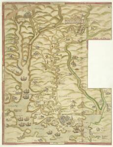
A coloured chart of Plymouth Harbour, and of the country up to Tavistock; drawn possibly by Robert Spry
This is a map of Plymouth and environs and is a 16th century copy of an original map dating from 1591 by Robert Spry. Spry is recorded as a painter in municipal records between 1569-70 and 1591-2. The map is drawn in a somewhat archaic pictorial style with topographical details drawn in perspective. Great detail has been observed in the depiction of churches and country houses and three beacons, the means of alerting the surrounding area, are recorded. The anchorages of the Sound are marked by drawings of ships. The map shows the conduit or leat that was constructed by Sir Francis Drake in 1590-1 in order to provide a water-supply for the town from Dartmoor. In connection with his leat, Drake had been granted a lease of the six town mills in 1583. The leat was designed for the watering of ships and to power the mills and played a central role in Drake’s hopeful project to make Plymouth a powerful naval station. Although popular local tradition suggested that Drake had employed magic in order to effect the construction of the leat which passed through "mighti rockes which was thought unpossible to carrie water through", it was in fact the work of the Plymouth engineers Robert Lampen and his brother. Figures along the course of the leat, from the River Meavy to Plymouth record miles. A section that is likely to have contained an explanatory table has been removed, resulting in the maps irregular shape. Spry, Robert
Plan of Plymouth harbour
Located in the south western peninsula of England, Plymouth Harbour commands the western approaches to the island and by the 16th century had become the country’s most important naval seaport. This plan depicts the harbour of Plymouth, as it was in the late 17th century, from St. Germains on the west to Saltram on the east.
To the Right Honorable the Master, Wardens & Elder Brethren of the Trinity House, this Chart of Plymouth Sound is ... dedicated
1 : 26000 Heather, W. (William) Heather, W. (William)
SX46 - OS 1:25,000 Provisional Series Map
1 : 25000 Topographic maps Ordnance Survey Ordnance Survey
Cornwall XLVI - OS Six-Inch Map
1 : 10560 Topographic maps Ordnance Survey Ordnance Survey
General Plan of the Ports of Homouse and Plymouth
Plan of the Ports of Hamoaze and Plymouth in Devon. This is the point where the rivers Tamar, Tavy and Lynher enter Plymouth Sound. Proposals for a dockyard at Hamoaze were first proposed by Sir Francis Drake in the late 16th century. It was felt that the broad estuary here afforded excellent natural protection however it was not until 1690 that work began here. William III appointed Edmund Dummer, surveyor to the Royal Navy, to build the dock and it became known as Plymouth Dock. By the 19th century Plymouth Dock was actually bigger than Plymouth itself and in 1824 it became independent, the town and the dockyard becoming known as Davenport. This is now the largest naval base in Western Europe.
Devonshire CXXIII - OS Six-Inch Map
1 : 10560 Topographic maps Ordnance Survey Ordnance Survey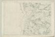
Devonshire CXVII - OS Six-Inch Map
1 : 10560 Topographic maps Ordnance Survey Ordnance Survey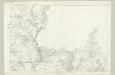
Devonshire CXVIII - OS Six-Inch Map
1 : 10560 Topographic maps Ordnance Survey Ordnance Survey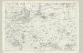
Devonshire CXXIV - OS Six-Inch Map
1 : 10560 Topographic maps Ordnance Survey Ordnance Survey
A chart of Plymouth Sound, with "il novo recinto della fortificatione de la ville de Pleymouth;"
This is a plan of the area around Plymouth Sound. It is orientated to the south with Penlee point to the south west and Bovisand Bay south east. It dates from 1601-1602 and may show the proposals of the Italian engineer Frederico Genibelli. Genibelli had been sent by the Privy Council in response to requests by the governor of the fort, Sir John Gilbert, that defects in the fortifications be repaired. Plymouth Sound is situated in such a way as to make it an ideal invasion target as although geographically far from heart of national government Plymouth was accessible to the outside world, especially France and Spain and provided access to centre of the country. This plan illustrates the position occupied by the fort in relation both to the town and to its surrounding countryside, although the latter is inaccurately portrayed out of scale. The town of Plymouth is surrounded by a perimeter wall. Beacons are shown at Staddon, Maker and Penlee, highlighting the measures in place to raise the alarm in case of invasion. When surveying the deficiencies in the defences of the fort and island, Genibelli outlined a new scheme for fortifying the town with nine ravelins at a cost of £3000. These are outworks which consist of two faces which form a salient angle. The proposed scheme is clearly shown here but was not carried out by the government. Genibelli, Frederico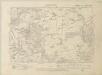
Cornwall XXX.NW - OS Six-Inch Map
1 : 10560 Topographic maps Ordnance Survey Ordnance Survey
Cornwall XXX.NW - OS Six-Inch Map
1 : 10560 Topographic maps Ordnance Survey Ordnance Survey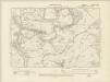
Cornwall XXX.SW - OS Six-Inch Map
1 : 10560 Topographic maps Ordnance Survey Ordnance Survey
Cornwall XXX.SW - OS Six-Inch Map
1 : 10560 Topographic maps Ordnance Survey Ordnance Survey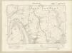
Cornwall XXXVIII.NW - OS Six-Inch Map
1 : 10560 Topographic maps Ordnance Survey Ordnance Survey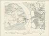
Cornwall XXXVIII.NW - OS Six-Inch Map
1 : 10560 Topographic maps Ordnance Survey Ordnance Survey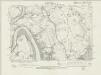
Cornwall XXXVIII.NW - OS Six-Inch Map
1 : 10560 Topographic maps Ordnance Survey Ordnance Survey
Cornwall XXXVIII.NW - OS Six-Inch Map
1 : 10560 Topographic maps Ordnance Survey Ordnance Survey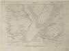
Cornwall XXXVIII.SW - OS Six-Inch Map
1 : 10560 Topographic maps Ordnance Survey Ordnance Survey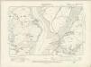
Cornwall XXXVIII.SW - OS Six-Inch Map
1 : 10560 Topographic maps Ordnance Survey Ordnance Survey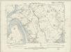
Cornwall XXXVIII.SW - OS Six-Inch Map
1 : 10560 Topographic maps Ordnance Survey Ordnance Survey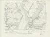
Cornwall XXXVIII.SW - OS Six-Inch Map
1 : 10560 Topographic maps Ordnance Survey Ordnance Survey
Cornwall XXXVIII.SW - OS Six-Inch Map
1 : 10560 Topographic maps Ordnance Survey Ordnance Survey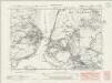
Cornwall XLVI.NW - OS Six-Inch Map
1 : 10560 Topographic maps Ordnance Survey Ordnance Survey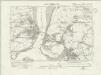
Cornwall XLVI.NW - OS Six-Inch Map
1 : 10560 Topographic maps Ordnance Survey Ordnance Survey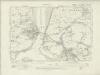
Cornwall XLVI.NW - OS Six-Inch Map
1 : 10560 Topographic maps Ordnance Survey Ordnance Survey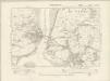
Cornwall XLVI.NW - OS Six-Inch Map
1 : 10560 Topographic maps Ordnance Survey Ordnance Survey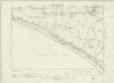
Cornwall XLVI.NW - OS Six-Inch Map
1 : 10560 Topographic maps Ordnance Survey Ordnance Survey