Maps of South Hams
Sheets 3-4. (Cary's England, Wales, and Scotland).
1 : 360000 Cary, John, ca. 1754-1835
Plymouth - OS One-Inch Map
1 : 63360 Topographic maps Ordnance Survey Ordnance Survey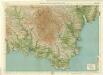
South Devon, Sheet 36 - Bartholomew's "Half Inch to the Mile Maps" of England & Wales
1 : 126720 Topographic maps Bartholomew, John George John Bartholomew & Co
Torquay - OS One-Inch Map
1 : 63360 Topographic maps Ordnance Survey Ordnance Survey
Dartmoor, Devon
This drawing shows the estuary of the River Dart flowing into the English Channel. Numerous slate and limestone quarries surround the busy port at Dartmouth Harbour. Dartmouth Port also served the tin and copper mines on Dartmoor. Tan yards are marked at Totnes and Ashburton. Many cider orchards are noted. An Old Cross is drawn at Saint Petrocks (St Petrox) near the ruins of a castle across the estuary at Kiln Cove. Another castle appears at Totnes. The ancient earthworks at Woodbury Camp and many other early settlements are recorded in this area. While the authorship of this drawing is unknown, the elaborate hill shading and attention to communications routes conform to the military and cartographic standards employed by the West Country survey. The map is made up of three pieces. Its margins are trimmed and the drawing is in good condition.
Ivybridge (Hills) - OS One-Inch Revised New Series
1 : 63360 Topographic maps Ordnance Survey Ordnance Survey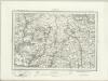
Ivybridge (Outline) - OS One-Inch Revised New Series
1 : 63360 Topographic maps Ordnance Survey Ordnance Survey
Kingsbridge (Hills) - OS One-Inch Revised New Series
1 : 63360 Topographic maps Ordnance Survey Ordnance Survey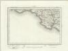
Kingsbridge (Outline) - OS One-Inch Revised New Series
1 : 63360 Topographic maps Ordnance Survey Ordnance Survey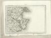
Torquay (Outline) - OS One-Inch Revised New Series
1 : 63360 Topographic maps Ordnance Survey Ordnance Survey
Torquay (Hills) - OS One-Inch Revised New Series
1 : 63360 Topographic maps Ordnance Survey Ordnance Survey
Start Point (Outline) - OS One-Inch Revised New Series
1 : 63360 Topographic maps Ordnance Survey Ordnance Survey
Start Point (Hills) - OS One-Inch Revised New Series
1 : 63360 Topographic maps Ordnance Survey Ordnance Survey
Kingsbridge, Devon
This drawing covers the coastal region around Salcombe, from Bantham and Thurlestone on to Stoke Fleming., It is attributed to Royal Military Surveyor and Draughtsman, Richard Searle, who took part in the West Country Survey from 1803 to 1807., He was one of the most competent surveyors to work on the survey, and taught gentlemen cadets the basics of surveying., Despite this,,he was only rated second-class in the Corps., On this map, the heavy-ink colour washes indicating the steepness of the hills make some of the,inland symbols,difficult to interpret.,,Square gridlines in pencil are prominent at the edges of the map, made to facilitate copying., The manuscript paper carries a watermark from the,James Whatman Turkey Mill., Searle, Richard
Ashburton(002OSD000000001U00018000)
Draughtsmen used the colour red to indicate stone, so the unbroken red line around Huntingdon Warren in the centre of the,map means that it was enclosed by a stone wall., Field boundaries are also shown, with those in red again representing stone walls., Notably, the draughtsman has drawn pecked red lines on this map, most obviously at Yealm River in the central left area., These may have represented stone circles., Place names are truncated where the margins of the manuscript have been trimmed. Dawson, Robert
A coloured chart of Plymouth Harbour, and of the country up to Tavistock; drawn possibly by Robert Spry
This is a map of Plymouth and environs and is a 16th century copy of an original map dating from 1591 by Robert Spry. Spry is recorded as a painter in municipal records between 1569-70 and 1591-2. The map is drawn in a somewhat archaic pictorial style with topographical details drawn in perspective. Great detail has been observed in the depiction of churches and country houses and three beacons, the means of alerting the surrounding area, are recorded. The anchorages of the Sound are marked by drawings of ships. The map shows the conduit or leat that was constructed by Sir Francis Drake in 1590-1 in order to provide a water-supply for the town from Dartmoor. In connection with his leat, Drake had been granted a lease of the six town mills in 1583. The leat was designed for the watering of ships and to power the mills and played a central role in Drake’s hopeful project to make Plymouth a powerful naval station. Although popular local tradition suggested that Drake had employed magic in order to effect the construction of the leat which passed through "mighti rockes which was thought unpossible to carrie water through", it was in fact the work of the Plymouth engineers Robert Lampen and his brother. Figures along the course of the leat, from the River Meavy to Plymouth record miles. A section that is likely to have contained an explanatory table has been removed, resulting in the maps irregular shape. Spry, Robert
Plan of Plymouth harbour
Located in the south western peninsula of England, Plymouth Harbour commands the western approaches to the island and by the 16th century had become the country’s most important naval seaport. This plan depicts the harbour of Plymouth, as it was in the late 17th century, from St. Germains on the west to Saltram on the east.
The environs of Plymouth, Devonport and Stonehouse : also the neighborhood of Exeter with the coast and other principal roads [...]
1 : 65000 engraved [...] by John Cooke Stonehouse : sold by John Cooke
A coloured scheme for fortifying the island of St Nicholas, or Drake's Island, in Plymouth Sound
Plan of Plymouth harbour with particular attention to St Nicholas Island thought to have been drawn by a French or Dutch artist. It is said that when he was a child, Sir Francis Drake was sent here by his parents for protection at a time of civil disturbance. In the 18th century the island was renamed Drake’s Island in his memory but until the mid 19th century it was still referred to as St Nicholas Island. The island was first fortified in the 17th century and was important because it was situated in the centre of Plymouth Sound and protected the approaches to the harbours and the estuaries of the rivers Tamar and Plym.
Torbay, Devon
Relief is shown on this drawing by dense brushwork interlining ('hachures'), with the summits of inclines left bare. It is partly the concern with accurate representation of relief that sets these drawings apart from the earlier county maps. Individual trees are shown with their shadows falling to the left. Rocky outcrops in Tor Bay are shown and the beach is tinted yellow. Quarter-inch squares, used to facilitate copying or reduction of the map, can be seen in pencil around the coastline. The drawing has been titled in ink and the scale is noted in the bottom left. It is not orientated to the north. Stanley, William
To the Right Honorable the Master, Wardens & Elder Brethren of the Trinity House, this Chart of Plymouth Sound is ... dedicated
1 : 26000 Heather, W. (William) Heather, W. (William)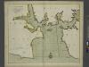
A new and correct large draught PLYMOUTH SOUND catt-water and ham-owse
from The sea-atlas : containing an hydrographical description of most of the sea-coasts of the known parts of the world.
Modbury, Devon
This drawing plots the estuaries of the Rivers Erme and Avon on the south Devon coast., The survey date is noted at the bottom right of the manuscript, along with the scale., The draughtsman is unknown, but the elaborate hill-shading and attention to communications routes conform to the military and cartographic standards employed in the overall survey., Square gridlines in pencil are visible at the boundaries of the map, made to facilitate copying.
Nieuwe afteekeningh van de haven van Plijmouth geleegen int Canaal aen de kust van Engeland
England Gerard van Keulen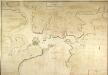
General Plan of the Ports of Homouse and Plymouth
Plan of the Ports of Hamoaze and Plymouth in Devon. This is the point where the rivers Tamar, Tavy and Lynher enter Plymouth Sound. Proposals for a dockyard at Hamoaze were first proposed by Sir Francis Drake in the late 16th century. It was felt that the broad estuary here afforded excellent natural protection however it was not until 1690 that work began here. William III appointed Edmund Dummer, surveyor to the Royal Navy, to build the dock and it became known as Plymouth Dock. By the 19th century Plymouth Dock was actually bigger than Plymouth itself and in 1824 it became independent, the town and the dockyard becoming known as Davenport. This is now the largest naval base in Western Europe.
SX47 - OS 1:25,000 Provisional Series Map
1 : 25000 Topographic maps Ordnance Survey Ordnance Survey
SX46 - OS 1:25,000 Provisional Series Map
1 : 25000 Topographic maps Ordnance Survey Ordnance Survey
SY08 & Parts of SY07 - OS 1:25,000 Provisional Series Map
1 : 25000 Topographic maps Ordnance Survey Ordnance Survey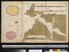
De rivier van Salcombe int groot
England Gerard van Keulen