Maps of Algeria
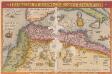
Barbarie Et Biledulgerid, Nova Descriptio. [Karte], in: Theatrum orbis terrarum, S. 317.
1 Karte aus Atlas Ortelius, Abraham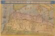
Barbariae Et Biledulgerid, Nova Descriptio. [Karte], in: Theatrum orbis terrarum, S. 122.
1 Karte aus Atlas Ortelius, Abraham
Prima Affrice Tabula [Karte], in: [Clavdii Ptholomei Cosmographi ...], S. 287.
1 Karte aus Atlas Nicolaus Germanus [und Ptolemaeus, Claudius]
[Das Mittelländische Meer und Nord-Afrika, Westliches Blatt]
Hand-Atlas über alle Theile der Erde und über das Weltgebäude Stieler, Adolf Justus Perthes
[Afrika, Blatt 1]
Adolf Stieler's Handatlas über alle Theile der Erde und über das Weltgebäude Stieler, Adolf Justus Perthes
[Das Mittelländische Meer und Nord-Afrika]
Handatlas über alle Theile der Erde und über das Weltgebäude Stieler, Adolf Justus Perthes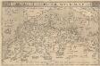
Barbarie Et Biledulgerid, Nova Descriptio. [Karte], in: Theatrum orbis terrarum, S. 418.
1 Karte aus Atlas Ortelius, Abraham Vrients, Jan Baptista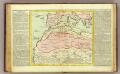
Barbarie.
1 : 11500000 Clouet, J. B. L. (Jean-Baptiste Louis), b. 1730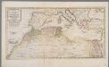
Het noordelykste deel van Afrika, behelzende Barbarie, Egypte enz. als mede de geheele Middellandsche Zee / volgens de nieuwste uitgave van den heer D'Anville
1 : 8215000 Annotatie: Oorspr. opgenomen in: Nieuwe en beknopte hand-atlas ... - Amsterdam : Isaak Tirion, [na 1769] Te Amsterdam : by Isaak Tirion
Evropa, 3
1 Blatt : 49 x 57 cm Homännische Erben
Le Transsaharien, conférence de Mr Paul Soleillet. Carte du chemin de fer transsaharien
1 : 20850000 Société de géographie commerciale de Bordeaux Bordeaux : Société de Géographie Commerciale de Bordeaux
Das Nordwestliche Africa
1 : 6300000 Weiland, Karl Ferdinand Geographisches Instituts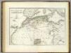
Nordwest. Africa.
1 : 6325000 Weiland, C. F. (Carl Ferdinand), d. 1847
Nordwestliches Africa
Neuer Handatlas über alle Theile der Erde Kiepert, Heinrich Verlag von Dietrich Reimer
Das Nordwestliche Africa enthaltend die Staaten Fez und Marokko, Algier, Tunis und Tripoli, die Sahara, Canarischen und Azorischen Inseln oder Atlas-Land und Tiefland von Africa
1 : 6325000 entw. und gezeichnet von C. F. Weiland C. Jungmann sc. Weimar : Verlag des Geograph. Instituts
Das Mittellandische Meer Und Nord-Afrika.
1 : 7500000 Petermann, A.
Afrique Septentrionale, Malte, Acores, Madere, Canaries.
1 : 7500000 Garnier, F. A., 1803-1863
Das Mittelländische Meer
Stieler's Hand-Atlas Stieler, Adolf bei Justus Perthes
[Quator Affrice tabula] [Karte], in: Clavdii Ptholomei Viri Alexandrini Cosmographie, S. 158.
1 Karte aus Atlas Nicolaus Germanus [und Ptolemaeus, Claudius]
Aphrica Tabula I. [Karte], in: Claud. Ptolemaeus. Geographia lat. cum mappis [...], S. 283.
1 Karte aus Atlas Münster, Sebastian [und Ptolemaeus, Claudius]
Barbaria [Karte], in: Gerardi Mercatoris Atlas, sive, Cosmographicae meditationes de fabrica mundi et fabricati figura, S. 499.
1 Karte aus Atlas Mercator, Gerhard Montanus, Petrus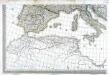
Carte d'Europe ou sont tracées les limites des empires, royaumes, et etats souverains, feuille 5
1 Blatt : 56 x 87 cm Semen etc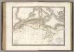
La Barbarie.
1 : 6500000 Lapie, M. (Pierre), 1779-1850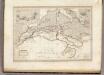
Afrique Septentrionale.
1 : 8000000 Montemont, A.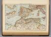
Mediterranean Sea W.
1 : 9000000 Andree, Richard; Times (London, England)
Mittelmeerlander westliche.
1 : 9000000 Andree, Richard
Tabula Prima Africae. [Karte], in: Claudii Ptolemei viri Alexandrini mathematice discipline philosophi doctissimi geographie opus [...], S. 181.
1 Karte aus Atlas Waldseemüller, Martin [und Ptolemaeus, Claudius] Übelin, Georg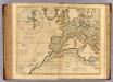
Theatrum historicum ad annum Christi quadringentesimu. Pars occidentalis.
1 : 8500000 L'Isle, Guillaume de, 1675-1726
Evropa raného středověku: do konce VI. století po Kr.
Kašpar, Jan
![Barbarie Et Biledulgerid, Nova Descriptio. [Karte], in: Theatrum orbis terrarum, S. 317.](https://images-2.georeferencer.com/images/iiif/069690505926/full/,300/0/native.jpg)

