Maps of Sahara

Barbaria [Karte], in: Gerardi Mercatoris Atlas, sive, Cosmographicae meditationes de fabrica mundi et fabricati figura, S. 499.
1 Karte aus Atlas Mercator, Gerhard Montanus, Petrus
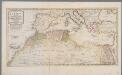
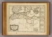
Het noordelykste deel van Afrika, behelzende Barbarie, Egypte enz. als mede de geheele Middellandsche Zee / volgens de nieuwste uitgave van den heer D'Anville
1 : 8215000 Annotatie: Oorspr. opgenomen in: Nieuwe en beknopte hand-atlas ... - Amsterdam : Isaak Tirion, [na 1769] Te Amsterdam : by Isaak Tirion
A new map of the north part of antient Africa shewing the chiefe people, cities, towns, rivers, mountains, &c. in Mauritania, Numidia, Africa Propria, Libya Propria and Egypt
1 : 1
BARBARIA.
[Amsterdam : Joan Blaeu]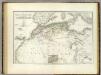
Nordwest. Africa.
1 : 6325000 Weiland, C. F. (Carl Ferdinand), d. 1847
Das Nordwestliche Africa enthaltend die Staaten Fez und Marokko, Algier, Tunis und Tripoli, die Sahara, Canarischen und Azorischen Inseln oder Atlas-Land und Tiefland von Africa
1 : 6325000 entw. und gezeichnet von C. F. Weiland C. Jungmann sc. Weimar : Verlag des Geograph. Instituts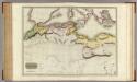
Northern Africa.
1 : 5300000 Pinkerton, John, 1758-1826
Das Nordwestliche Africa
1 : 6300000 Weiland, Karl Ferdinand Geographisches Instituts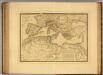
Nord de l'Afrique, Mer Mediterranee, Europe Meridionale.
1 : 9300000 Picquet, C.
Mediterranean, Black Sea cables, wireless stations.
1 : 13000000 Philip, George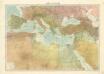
Středomoří
Barbarie.
1 : 17200000 Delamarche, Charles Francois; Lattre, Jean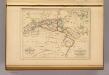
Barbarie.
1 : 12300000 Malte-Brun, Conrad, 1775-1826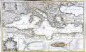
La mer Mediterranée
1 Karte auf 2 Blättern : Kupferdruck ; 53 x 87 cm Sanson; Denis; Basset; Basset chès Basset rue St. Jacques au coin de celle des Mathurins à l'Image S.e Genevieve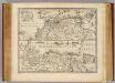
Parts of Barbary.
1 : 7700000 Bowen, Emanuel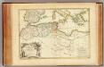
Barbarie.
1 : 8600000 Bonne, Rigobert, 1727-1794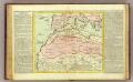
Barbarie.
1 : 11500000 Clouet, J. B. L. (Jean-Baptiste Louis), b. 1730
Das Mittellandische Meer Und Nord-Afrika.
1 : 7500000 Petermann, A.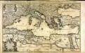
La mer Mediterranée
1 Karte auf 2 Blatt : Kupferdruck ; 53 x 86 cm Sanson; Jaillot chez H. Iaillot joignant les grands Augustins aux 2 Globes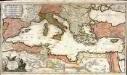
La mer Mediterranée
1 Karte auf 2 Blatt : Kupferdruck ; 47 x 85 cm Valck par G. Valck sur le Dam
Libyae vel Africae.
1 : 8200000 Playfair, Principal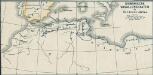
Osmanische Vasallenstaaten in Nordwest-Afrika
1 : 27000000 Osmanisches Reich, Maghreb , Protektorat
Libyae, vel Africae pars borealis.
1 : 25000000 Fenner, Rest.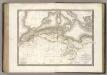
La Barbarie.
1 : 6500000 Lapie, M. (Pierre), 1779-1850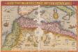
Barbarie Et Biledulgerid, Nova Descriptio. [Karte], in: Theatrum orbis terrarum, S. 317.
1 Karte aus Atlas Ortelius, Abraham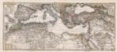
Composite: Mittellandische Meer, Nord-Afrika.
1 : 7500000 Petermann, A.
Nord-Ouest de l'Afrique.
1 : 12100000 Vivien de St Martin, L.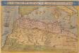
Barbariae Et Biledulgerid, Nova Descriptio. [Karte], in: Theatrum orbis terrarum, S. 122.
1 Karte aus Atlas Ortelius, Abraham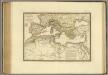
![Barbaria [Karte], in: Gerardi Mercatoris Atlas, sive, Cosmographicae meditationes de fabrica mundi et fabricati figura, S. 499.](https://images-2.georeferencer.com/images/iiif/515401410551/full/,300/0/native.jpg)

