Maps of Sahara
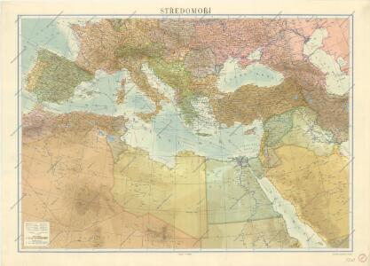
Středomoří

[Hierographie, oder topographisch-synchronistische Darstellung der Geschichte der christlichen Kirche] : VI. Von Constantin bis auf Gregor d. G. J. 325-604
1 : 8400000 W.A. Möller Lith. bey Arnz & Co. in Düsseldorf Elberfeld : Büschler
[Hierographie, oder topographisch-synchronistische Darstellung der Geschichte der christlichen Kirche] : II. Von Paulus bis Origines
1 : 8400000 W.A. Möller Lith. bey Arnz & Co. in Düsseldorf Elberfeld : Büschler
[Hierographie, oder topographisch-synchronistische Darstellung der Geschichte der christlichen Kirche] : I. Zeiten der Apostel
1 : 8400000 W.A. Möller Lith. bey Arnz & Co. in Düsseldorf Elberfeld : Büschler
[Hierographie, oder topographisch-synchronistische Darstellung der Geschichte der christlichen Kirche] : IV. Von Constantin bis auf Gregor d. G. J. 325-604
1 : 8400000 W.A. Möller Lith. bey Arnz & Co. in Düsseldorf Elberfeld : Büschler
[Hierographie, oder topographisch-synchronistische Darstellung der Geschichte der christlichen Kirche] : III. Origines - Nicaea
1 : 8400000 W.A. Möller Lith. bey Arnz & Co. in Düsseldorf Elberfeld : Büschler
[Hierographie, oder topographisch-synchronistische Darstellung der Geschichte der christlichen Kirche] : V. Von Constantin bis auf Gregor d. G. J. 325-604
1 : 8400000 W.A. Möller Lith. bey Arnz & Co. in Düsseldorf Elberfeld : Büschler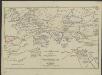
[Hierographie, oder topographisch-synchronistische Darstellung der Geschichte der christlichen Kirche] : VII. Von Gregor d. Gr. bis auf Carl d. G. J. 604-800
1 : 8400000 W.A. Möller Lith. bey Arnz & Co. in Düsseldorf Elberfeld : Büschler
Verbreitung der Religionen im Anfange von Justinians Regierung
1 : 30000000 Europa Justinian I., Byzantinisches Reich, Kaiser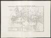
Carta generale dell'impero romano sotto Costantino
1 : 11000000 Marzolla, Benedetto [Verlag nicht ermittelbar]
[Das Mittellaendische und Schwarze Meer, Auch als General Karte des Osmanischen Reichs]
Hand-Atlas über alle Theile der Erde nach dem neuesten Zustande und über das Weltgebäude Stieler, Adolf bei Justus Perthes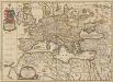
Europa Antiqua cum finitimis Africae & utriusque Asiae regionibus. [Karte], in: Novus atlas absolutissimus, Bd. 10, S. 33.
1 Karte aus Atlas Janssonius Offizin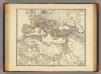
Imperium Romanum inde a bello Actiaco usque ad Diocletiani tempus.
1 : 15000000 Menke, Th.
Imperium Romanum Antiquum
Römisches Reich

Europa antiqua cum finitimis Africæ & utriusque Asiæ regionibus / Nicolaus Blancardus ... delineabat
1 : 10000000 Annotatie: Origineel is Blad 2 in atlas factice Blanckaert, Nicolaas [Amsterdam : Joannes Janssonius]
Terre aux trois fils de Noe.
1 : 23500000 Houze, Antoine Philippe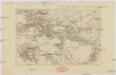
Mundus quem perlustraverunt descripseruntq[ue] ... Beniamin ben Ionahidelensis 1160-1173 et ... Petahia ratisboensis 1175
Afrika severní
Das Römische Reich in der Kaiserzeit
starověký Řím Gindely, Antonín F. Tempsky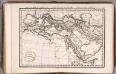
Carte de Premiers Ages de Monde ... 1825.
1 : 17500000 Delamarche, Felix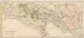
Země při moři Středozemském v době největší rozsáhlosti říše perské

Středomoří a Sev. Afrika

Carte Générale de L'Empire Ottoman en Europe, en Asie et en Afrique
Nouvel atlas physique politique et historique de l'Empire ottoman et des états limitrophes en Europe, en Asie et en Afrique, en quarante feuilles Hellert, J.J. Bellizard, Dufour et Cie
Gemälde der grossen Wanderungen der Barbaren
Historisch-genealogisch-geographischer Atlas von Le Sage Las Cases, Emmanuel Auguste Dieudonné Marius Joseph de Johann Velten, Kunsthändler
Carte des peuples de l’Europe centrale lors de l’apparation des Huns, au 4e siècle de notre ère
Mitteleuropa ethnische Gruppe, Völkerwanderungszeit
[Das Mittellaendische und Schwarze Meer. Auch als General Karte des Osmanischen Reichs]
Hand-Atlas über alle Theile der Erde nach dem neuesten Zustande und über das Weltgebäude Stieler, Adolf bei Justus Perthes
Ancient Roman empire
J. Dower Henry Teesdale & C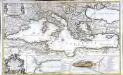
La mer Mediterranée
1 Karte auf 2 Blättern : Kupferdruck ; 53 x 87 cm Sanson; Denis; Basset; Basset chès Basset rue St. Jacques au coin de celle des Mathurins à l'Image S.e Genevieve
Imperium Romanum.
1 : 15000000 Kiepert, Heinrich, 1818-1899