Maps of South Aegean Region

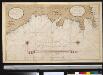
Archipelagi Meridionalis seu Cycladum Insularum accurata Delineatio. [Karte], in: Novus atlas absolutissimus, Bd. 10, S. 234.
1 Karte aus Atlas Janssonius Offizin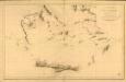
Carte réduite de la partie Méridionale de l’Archipel
Carte réduite de la partie Méridionale de l'Archipel, rédigée d'après les travaux exécutées dans les années 1818 & 1819 par M. Gauttier. [Paris] : Dépôt Général de la Marine
CYCLADES | INSVLÆ | IN MARE ÆGÆO, | hodie | ARCHIPELAGO
Auctore | I. LAVRENBERGIO Amsterdami, J. Blaeu excudit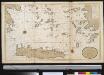
Het zuijderdeel van de Archipel Lagusche Eijlanden int groodt
Greece Gerard van Keulen
Iles de L'archipel; Dschezaïr
Nouvel atlas physique politique et historique de l'Empire ottoman et des états limitrophes en Europe, en Asie et en Afrique, en quarante feuilles Hellert, J.J. Bellizard, Dufour et Cie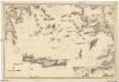
Mittelmeer
1 : 600000 Egejské moře Reichs-Marine-Amt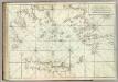
Carte De La Mer Mediterranee. XI.
Roux, Joseph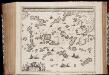
Archipelagi meridionalis, seu Cycladum insularum accurata delineatio / auctore I. Laurenbergio
1 : 650000 Annotatie: Kaart uitgegeven in de periode 1650-1662; Origineel is Blad 171 in atlas factice; Annotatie geografische gegevens: 4 schaalstokken: 8 Mill. Germ., en: 10 Mill. Gall., en: 30 Mill. Ital., en: 300 Stadia [S.l.] : [s.n.]
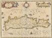
Insula Creta hodie Candia
1 : 900000 Kréta (Řecko) Homann, Johann Baptist Joh. Bapt. Homannus
Die Cycladischen Inseln
1 : 1160000 Kyklady (Řecko) Anville, Jean-Baptiste Bourguinon d'
Insula Creta nunc Candia
1 : 900000 Kréta (Řecko) Lotter, Tobias Conrad Tob. Conr. Lotter
Insula Candia olim Creta. [Karte], in: Novus atlas absolutissimus, Bd. 9, S. 317.
1 Karte aus Atlas Janssonius Offizin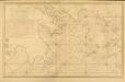
Carte des Côtes de la Grèce depuis Navarin en Morée
Carte des Côtes de la Grèce depuis Navarin en Morée, jusqu'au Cap Doro ... avec la partie de l'Archipel qu comprend les Îles Cyclades, dressée d'après les observations astronomiques et nautiques de M. de Chabert. [Paris] : Dépôt Général ... de la Marine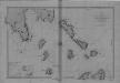
Begulia, Melada Island, Dalmatia
Port Beguglia ... Levé en 1819 par le Capit. W. H. Smyth. [Paris],
Rhodus Ins. [Karte], in: Gerardi Mercatoris Atlas, sive, Cosmographicae meditationes de fabrica mundi et fabricati figura, S. 523.
1 Karte aus Atlas Mercator, Gerhard Montanus, Petrus
Insula Creta nunc Candia in sua 4 territoria distincta, cum aliquod adjacentibus AEgei maris insulis imprimis Nova Santorini insula modo ante 27 annos ex Abysso Maris emersa
1 : 930000 Kréta (Řecko) Seutter, Matthäus M. Seutter
Archipelagi Insularum Aliquot Descrip., [Rodus] [Karte], in: Theatrum orbis terrarum, S. 341.
1 Karte aus Atlas Ortelius, Abraham Vrients, Jan Baptista
[INSULA CRETA hodie CANDIA]
1 : 925000 Egejské moře-oblast Homann, Johann Baptist Ioh. Bapt. Homannus
Archipelagi Insularum Aliquot Descrip., [Rodus] [Karte], in: Theatrum orbis terrarum, S. 246.
1 Karte aus Atlas Ortelius, Abraham
Een gedeelte van het eijland Candia vertoonende de Noord West zijde
Greece Gerard van Keulen
Candia olim Creta. [Karte], in: Novus atlas absolutissimus, Bd. 5, S. 294.
1 Karte aus Atlas Janssonius Offizin
Candia, olim Creta. [Karte], in: Novus Atlas, das ist, Weltbeschreibung, Bd. 3, S. 349.
1 Karte aus Atlas Blaeu, Joan Blaeu, Willem Janszoon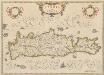
Candia, olim Creta. [Karte], in: Theatrum orbis terrarum, sive, Atlas novus, Bd. 3, S. 297.
1 Karte aus Atlas Blaeu, Joan Blaeu, Willem Janszoon
Candia, olim Creta. [Karte], in: Le théâtre du monde, ou, Nouvel atlas contenant les chartes et descriptions de tous les païs de la terre, Bd. 3, S. 309.
1 Karte aus Atlas Blaeu, Willem Janszoon und Blaeu, Joan Blaeu, Willem Janszoon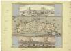
Insula Candia olim Creta
Kréta (Řecko) Weiland, Karl Ferdinand Visscher, Nicolaus N. Visscher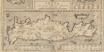
Creta Iovis magni, medio iacet insula ponto. [Karte], in: Theatrum orbis terrarum, S. 520.
1 Karte aus Atlas Ortelius, Abraham Vrients, Jan Baptista
Isle et royaume de Candie
1 : 810000 Kréta (Řecko) Sanson, Nicolas Cordier, Louis Pierre Mariette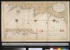
![Archipelagi Meridionalis seu Cycladum Insularum accurata Delineatio. [Karte], in: Novus atlas absolutissimus, Bd. 10, S. 234.](https://images-2.georeferencer.com/images/iiif/256124390918/full/,300/0/native.jpg)

