Maps of Cyclades

Insula Creta hodie Candia
1 : 900000 Kréta (Řecko) Homann, Johann Baptist Joh. Bapt. Homannus
CYCLADES | INSVLÆ | IN MARE ÆGÆO, | hodie | ARCHIPELAGO
Auctore | I. LAVRENBERGIO Amsterdami, J. Blaeu excudit
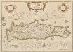
Insula Creta nunc Candia
1 : 900000 Kréta (Řecko) Lotter, Tobias Conrad Tob. Conr. Lotter
Die Cycladischen Inseln
1 : 1160000 Kyklady (Řecko) Anville, Jean-Baptiste Bourguinon d'
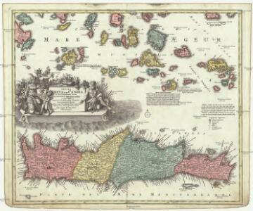
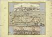
Insula Creta nunc Candia in sua 4 territoria distincta, cum aliquod adjacentibus AEgei maris insulis imprimis Nova Santorini insula modo ante 27 annos ex Abysso Maris emersa
1 : 930000 Kréta (Řecko) Seutter, Matthäus M. Seutter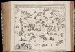
Archipelagi meridionalis, seu Cycladum insularum accurata delineatio / auctore I. Laurenbergio
1 : 650000 Annotatie: Kaart uitgegeven in de periode 1650-1662; Origineel is Blad 171 in atlas factice; Annotatie geografische gegevens: 4 schaalstokken: 8 Mill. Germ., en: 10 Mill. Gall., en: 30 Mill. Ital., en: 300 Stadia [S.l.] : [s.n.]
[INSULA CRETA hodie CANDIA]
1 : 925000 Egejské moře-oblast Homann, Johann Baptist Ioh. Bapt. Homannus
Insula Candia olim Creta. [Karte], in: Novus atlas absolutissimus, Bd. 9, S. 317.
1 Karte aus Atlas Janssonius Offizin


Isle et royaume de Candie
1 : 810000 Kréta (Řecko) Sanson, Nicolas Cordier, Louis Pierre Mariette
Candia, olim Creta. [Karte], in: Theatrum orbis terrarum, sive, Atlas novus, Bd. 3, S. 297.
1 Karte aus Atlas Blaeu, Joan Blaeu, Willem Janszoon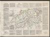
Candia, olim Creta. [Karte], in: Le théâtre du monde, ou, Nouvel atlas contenant les chartes et descriptions de tous les païs de la terre, Bd. 3, S. 309.
1 Karte aus Atlas Blaeu, Willem Janszoon und Blaeu, Joan Blaeu, Willem Janszoon
Candia, olim Creta. [Karte], in: Novus Atlas, das ist, Weltbeschreibung, Bd. 3, S. 349.
1 Karte aus Atlas Blaeu, Joan Blaeu, Willem Janszoon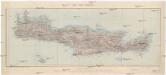
Ile de Crete
1 : 400000 Kréta (Řecko : ostrov) Service géographique de l'armée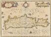
Candia olim Creta. [Karte], in: Novus atlas absolutissimus, Bd. 5, S. 294.
1 Karte aus Atlas Janssonius Offizin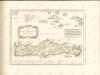
Insula Candia olim Creta
Kréta (Řecko) Weiland, Karl Ferdinand Visscher, Nicolaus N. Visscher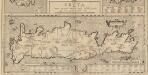
Creta Iovis magni, medio iacet insula ponto. [Karte], in: Theatrum orbis terrarum, S. 520.
1 Karte aus Atlas Ortelius, Abraham Vrients, Jan Baptista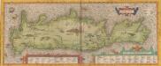
Creta Iovis magni, medio iacet insula ponto. [Karte], in: Theatrum orbis terrarum, S. 416.
1 Karte aus Atlas Ortelius, Abraham
Candia cum Insulis aliquot circa Graeciam[:] [Zypern] [Karte], in: Gerardi Mercatoris Atlas, sive, Cosmographicae meditationes de fabrica mundi et fabricati figura, S. 493.
1 Karte aus Atlas Mercator, Gerhard Montanus, Petrus
Candia olim Creta
1 : 3830000 Kréta (Řecko)

INSULA | CANDIA | olim | CRETA.
N. Visscher exc.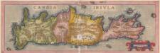
Candia Insula. [Karte], in: Theatrum orbis terrarum, S. 246.
1 Karte aus Atlas Ortelius, Abraham
Candia cum Insulis aliquot circa Graeciam[:] [Zypern] [Karte], in: Gerardi Mercatoris et I. Hondii Newer Atlas, oder, Grosses Weltbuch, Bd. 2, S. 336.
1 Karte aus Atlas Mercator, Gerhard und Hondius, Jodocus Jansson, Jan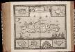
Insula Candia ejusque fortificatio / edita per F. de Wit
1 : 475000 Annotatie: Rechtsboven: 23; Origineel is Blad 173 in atlas factice; Annotatie geografische gegevens: Schaalstok: 15 Milliaria Germanica communia; Inzetkaarten van: Canea, Candia, Spina Longa, Retimo, Thine, Suda Frederick de Wit 1630-1706 Amsterdam : Gedruckt by Frederick de Wit inde Kalverstraet inde Witte Paskaert
CANDIA, | olim | CRETA
[Amsterdam : Joan Blaeu]